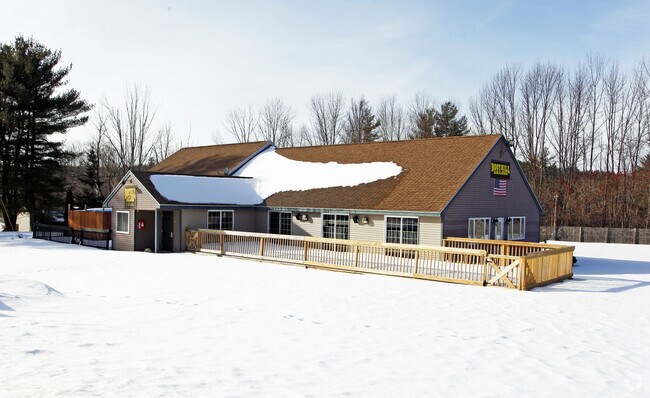
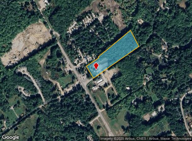
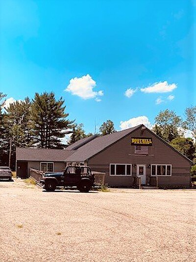
Property Record
1065 Watson Rd, Laconia, NH 03246
NEARBY LISTINGS FOR SALE OR LEASE
Property Detail
1065 Watson Rd
Laconia, NH
Belknap
LACO-000115-000280-000003
New Hampshire
Apartment
3
2024
6.60 AC
2024
Concord/New Hampshire North Area
966200
Other Market Areas
3,843 SF
DEMOGRAPHICS near 1065 Watson Rd
1 Mile
3 Mile
5 Mile
2024 Total Population
686
8,518
17,941
2029 Population
757
9,263
19,305
Pop Growth 2024-2029
+ 10.35%
+ 8.75%
+ 7.60%
Average Age
51
50
50
2024 Total Households
325
3,942
8,189
HH Growth 2024-2029
+ 10.77%
+ 8.88%
+ 7.60%
Median Household Inc
$102,734
$88,597
$83,573
Avg Household Size
2.00
2.10
2.10
2024 Avg HH Vehicles
2.00
2.00
2.00
Median Home Value
$378,069
$383,914
$369,933
Median Year Built
1981
1982
1982
Nearby Places
Map Layers
Map Styles
 Street
 Aerial
- Restaurants
- Banks
- Shops
- Fitness
- Groceries
SALE & LEASE HISTORY
LISTING DATE
SALE/LEASE

Sep 23, 2016
For Sale
Oct 03, 2017
For Sale
Mar 28, 2017
For Sale
Jun 26, 2020
For Sale
Dec 06, 2017
For Lease
Nearby Properties
Address
Land Use
TOTAL SIZE
Lot Size
Zoning
Address
Land Use
TOTAL SIZE
Lot Size
Zoning
588,961 SF
104.85 AC
REGION
Address
Land Use
TOTAL SIZE
Lot Size
Zoning
1,064 SF
199.78 AC
RS
Address
Land Use
TOTAL SIZE
Lot Size
Zoning
Address
Land Use
TOTAL SIZE
Lot Size
Zoning
61,304 SF
4.02 AC
CB
Address
Land Use
TOTAL SIZE
Lot Size
Zoning
100,579 SF
10.16 AC
CS&S
Address
Land Use
TOTAL SIZE
Lot Size
Zoning
112.60 AC
S
Address
Land Use
TOTAL SIZE
Lot Size
Zoning
8.91 AC
R
Address
Land Use
TOTAL SIZE
Lot Size
Zoning
14.48 AC
RA
Address
Land Use
TOTAL SIZE
Lot Size
Zoning
124.80 AC
RR1
Address
Land Use
TOTAL SIZE
Lot Size
Zoning
3.73 AC
CB
Address
Land Use
TOTAL SIZE
Lot Size
Zoning
102.80 AC
RR1
Address
Land Use
TOTAL SIZE
Lot Size
Zoning
29,927 SF
5.70 AC
CB
Address
Land Use
TOTAL SIZE
Lot Size
Zoning
Address
Land Use
TOTAL SIZE
Lot Size
Zoning
15.26 AC
R&FR
Address
Land Use
TOTAL SIZE
Lot Size
Zoning
1,600 SF
4.40 AC
CR
Address
Land Use
TOTAL SIZE
Lot Size
Zoning
1.60 AC
SFR
Address
Land Use
TOTAL SIZE
Lot Size
Zoning
63,078 SF
25.42 AC
Address
Land Use
TOTAL SIZE
Lot Size
Zoning
21,284 SF
1.06 AC
CB
Address
Land Use
TOTAL SIZE
Lot Size
Zoning
2,860 SF
1.70 AC
SFR
Address
Land Use
TOTAL SIZE
Lot Size
Zoning
20,564 SF
1.67 AC
CB
Address
Land Use
TOTAL SIZE
Lot Size
Zoning
968 SF
1.39 AC
SFR
Address
Land Use
TOTAL SIZE
Lot Size
Zoning
5,674 SF
1.60 AC
CR
Address
Land Use
TOTAL SIZE
Lot Size
Zoning
6,070 SF
0.80 AC
SFR
Address
Land Use
TOTAL SIZE
Lot Size
Zoning
1,882 SF
1.31 AC
S
Address
Land Use
TOTAL SIZE
Lot Size
Zoning
468 SF
2.43 AC
CR
Address
Land Use
TOTAL SIZE
Lot Size
Zoning
7,168 SF
1.39 AC
CB&R
Address
Land Use
TOTAL SIZE
Lot Size
Zoning
11.23 AC
CB
Address
Land Use
TOTAL SIZE
Lot Size
Zoning
0.94 AC
SFR
Address
Land Use
TOTAL SIZE
Lot Size
Zoning
0.73 AC
S
Address
Land Use
TOTAL SIZE
Lot Size
Zoning
6,800 SF
2.60 AC
CR
The World's #1 Commercial Real Estate Marketplace
Connect with us
© 2025 CoStar Group
The information above has been obtained from sources believed reliable. While we do not doubt its accuracy we have not verified it and make no guarantee, warranty or representation about it. It is your responsibility to independently confirm its accuracy and completeness. Any projections, opinions, assumptions, or estimates used are for example only and do not represent the current or future performance of the property. The value of this transaction to you depends on tax and other factors which should be evaluated by your tax, financial, and legal advisors. You and your advisors should conduct a careful, independent investigation of the property to determine to your satisfaction the suitability of the property for your needs.