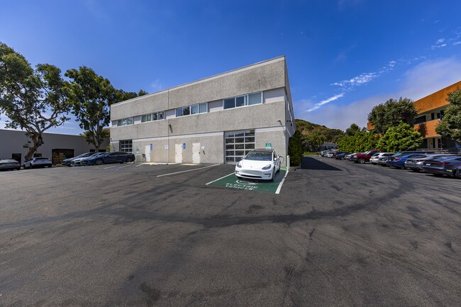
Property Record
10655 Roselle St, San Diego, CA 92121


NEARBY LISTINGS FOR SALE OR LEASE
Property Detail
10655 Roselle St
San Diego-Carlsbad, CA
University Sorrento Indust
340-150-30
LOT 8 LOT 7& TR 006218
Lightindustrial
San Diego
X
California
06073C1338G
8,7
2024
0.90 AC
2025
Sorrento Valley
008339
San Diego
22,273 SF
DEMOGRAPHICS near 10655 Roselle St
1 Mile
3 Mile
5 Mile
2024 Total Population
1,041
81,385
204,707
2029 Population
1,057
81,562
204,094
Pop Growth 2024-2029
+ 1.54%
+ 0.22%
(0.30%)
Average Age
35
34
39
2024 Total Households
395
30,105
75,699
HH Growth 2024-2029
+ 1.52%
+ 0.43%
(0.25%)
Median Household Inc
$135,937
$105,435
$123,830
Avg Household Size
2.60
2.30
2.50
2024 Avg HH Vehicles
2.00
2.00
2.00
Median Home Value
$863,013
$971,175
$987,654
Median Year Built
1999
1991
1985
Nearby Places
Map Layers
Map Styles
 Street
 Aerial
- Restaurants
- Banks
- Shops
- Fitness
- Groceries
PUBLIC TRANSPORTATION
COMMUTER RAIL
Sorrento Valley (Coaster - San Diego North County Transit District (Coaster/Sprinter/Breeze))
DRIVE
WALK
Distance
Sorrento Valley (Coaster - San Diego North County Transit District (Coaster/Sprinter/Breeze))
4 min
10 min
0.5 mi
Solana Beach (Coaster - San Diego North County Transit District (Coaster/Sprinter/Breeze))
DRIVE
WALK
Distance
Solana Beach (Coaster - San Diego North County Transit District (Coaster/Sprinter/Breeze))
14 min
8.7 mi
AIRPORT
San Diego International
DRIVE
WALK
Distance
San Diego International
20 min
13.4 mi
SALE & LEASE HISTORY
LISTING DATE
SALE/LEASE

Jun 02, 2025
For Sale
Feb 03, 2020
For Sale
Aug 08, 2023
For Lease
Aug 08, 2023
For Sale
Nearby Properties
Address
Land Use
TOTAL SIZE
Lot Size
Zoning
Address
Land Use
TOTAL SIZE
Lot Size
Zoning
40.28 AC
CR-1-1
Address
Land Use
TOTAL SIZE
Lot Size
Zoning
28.94 AC
IL-2-1
Address
Land Use
TOTAL SIZE
Lot Size
Zoning
15.78 AC
IL-2-1
Address
Land Use
TOTAL SIZE
Lot Size
Zoning
224,589 SF
7.23 AC
IL-2-1
Address
Land Use
TOTAL SIZE
Lot Size
Zoning
18.02 AC
IL-2-1
Address
Land Use
TOTAL SIZE
Lot Size
Zoning
1.67 AC
C
Address
Land Use
TOTAL SIZE
Lot Size
Zoning
3.88 AC
CC-1-3
Address
Land Use
TOTAL SIZE
Lot Size
Zoning
7.17 AC
IP-1-1
Address
Land Use
TOTAL SIZE
Lot Size
Zoning
3.50 AC
C-6
Address
Land Use
TOTAL SIZE
Lot Size
Zoning
1.31 AC
RS-1-14
Address
Land Use
TOTAL SIZE
Lot Size
Zoning
1.24 AC
C
Address
Land Use
TOTAL SIZE
Lot Size
Zoning
5.04 AC
IL-2-1
Address
Land Use
TOTAL SIZE
Lot Size
Zoning
2.49 AC
IP-1-1
Address
Land Use
TOTAL SIZE
Lot Size
Zoning
3.51 AC
RS-1-14
Address
Land Use
TOTAL SIZE
Lot Size
Zoning
12.69 AC
IP-1-1
Address
Land Use
TOTAL SIZE
Lot Size
Zoning
4.62 AC
IP-2-1
Address
Land Use
TOTAL SIZE
Lot Size
Zoning
7.36 AC
RM-3-9
Address
Land Use
TOTAL SIZE
Lot Size
Zoning
10.97 AC
CV-1-1
Address
Land Use
TOTAL SIZE
Lot Size
Zoning
1.59 AC
C
Address
Land Use
TOTAL SIZE
Lot Size
Zoning
4.81 AC
C-6
Address
Land Use
TOTAL SIZE
Lot Size
Zoning
10.68 AC
IL-2-1
Address
Land Use
TOTAL SIZE
Lot Size
Zoning
11.60 AC
RM-2-5
Address
Land Use
TOTAL SIZE
Lot Size
Zoning
5.51 AC
RS-1-14
Address
Land Use
TOTAL SIZE
Lot Size
Zoning
15.70 AC
IP-1-1
Address
Land Use
TOTAL SIZE
Lot Size
Zoning
41.66 AC
IP-1-1
Address
Land Use
TOTAL SIZE
Lot Size
Zoning
14.94 AC
CC-1-3
Address
Land Use
TOTAL SIZE
Lot Size
Zoning
4.31 AC
IL-3-1
Address
Land Use
TOTAL SIZE
Lot Size
Zoning
16.52 AC
IP-1-1
Address
Land Use
TOTAL SIZE
Lot Size
Zoning
1.34 AC
IL-2-1
Address
Land Use
TOTAL SIZE
Lot Size
Zoning
4.07 AC
RM-3-9
The World's #1 Commercial Real Estate Marketplace
Connect with us
© 2025 CoStar Group
The information above has been obtained from sources believed reliable. While we do not doubt its accuracy we have not verified it and make no guarantee, warranty or representation about it. It is your responsibility to independently confirm its accuracy and completeness. Any projections, opinions, assumptions, or estimates used are for example only and do not represent the current or future performance of the property. The value of this transaction to you depends on tax and other factors which should be evaluated by your tax, financial, and legal advisors. You and your advisors should conduct a careful, independent investigation of the property to determine to your satisfaction the suitability of the property for your needs.