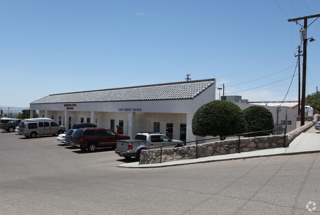
Property Record
10657 Vista Del Sol Dr, El Paso, TX 79935

NEARBY LISTINGS FOR SALE OR LEASE
Property Detail
10657 Vista Del Sol Dr
El Paso, TX
Vista Del Sol
V893-999-0030-9000
3 VISTA DEL SOL #2 REPLAT B LOT 26 (60240.00 SQ FT)
Commercialnec
El Paso
X
Texas
4802140042C
26
2024
1.38 AC
2025
East
004312
El Paso
13,750 SF
DEMOGRAPHICS near 10657 Vista Del Sol Dr
1 Mile
3 Mile
5 Mile
2024 Total Population
12,906
130,731
258,340
2029 Population
13,048
131,765
259,927
Pop Growth 2024-2029
+ 1.10%
+ 0.79%
+ 0.61%
Average Age
41
40
39
2024 Total Households
5,189
49,302
92,653
HH Growth 2024-2029
+ 1.16%
+ 0.79%
+ 0.64%
Median Household Inc
$48,566
$47,773
$48,974
Avg Household Size
2.50
2.60
2.70
2024 Avg HH Vehicles
2.00
2.00
2.00
Median Home Value
$173,578
$148,937
$146,143
Median Year Built
1973
1975
1980
Nearby Places
Map Layers
Map Styles
 Street
 Aerial
- Restaurants
- Banks
- Shops
- Fitness
- Groceries
PUBLIC TRANSPORTATION
AIRPORT
El Paso International
DRIVE
WALK
Distance
El Paso International
17 min
7.3 mi
SALE & LEASE HISTORY
LISTING DATE
SALE/LEASE

Dec 13, 2018
For Lease
Apr 02, 2022
For Lease
Nearby Properties
Address
Land Use
TOTAL SIZE
Lot Size
Zoning
Address
Land Use
TOTAL SIZE
Lot Size
Zoning
600,211 SF
114.73 AC
RF
Address
Land Use
TOTAL SIZE
Lot Size
Zoning
753,996 SF
23.50 AC
C4
Address
Land Use
TOTAL SIZE
Lot Size
Zoning
1,122,782 SF
55.24 AC
C4
Address
Land Use
TOTAL SIZE
Lot Size
Zoning
1 SF
M1
Address
Land Use
TOTAL SIZE
Lot Size
Zoning
380,811 SF
22.75 AC
M1
Address
Land Use
TOTAL SIZE
Lot Size
Zoning
343,190 SF
31.84 AC
C4
Address
Land Use
TOTAL SIZE
Lot Size
Zoning
1 SF
Address
Land Use
TOTAL SIZE
Lot Size
Zoning
289.07 AC
Address
Land Use
TOTAL SIZE
Lot Size
Zoning
135,639 SF
211.63 AC
C4
Address
Land Use
TOTAL SIZE
Lot Size
Zoning
377,168 SF
8.40 AC
C1
Address
Land Use
TOTAL SIZE
Lot Size
Zoning
80,049 SF
8.90 AC
C4
Address
Land Use
TOTAL SIZE
Lot Size
Zoning
235,670 SF
10 AC
A3C
Address
Land Use
TOTAL SIZE
Lot Size
Zoning
195,101 SF
15.45 AC
C1
Address
Land Use
TOTAL SIZE
Lot Size
Zoning
202,253 SF
10.70 AC
A2
Address
Land Use
TOTAL SIZE
Lot Size
Zoning
166,671 SF
24.61 AC
C4S
Address
Land Use
TOTAL SIZE
Lot Size
Zoning
125,896 SF
8.67 AC
R3
Address
Land Use
TOTAL SIZE
Lot Size
Zoning
192,261 SF
8.07 AC
A3C
Address
Land Use
TOTAL SIZE
Lot Size
Zoning
206,726 SF
24.42 AC
M1S
Address
Land Use
TOTAL SIZE
Lot Size
Zoning
154,016 SF
8.05 AC
A2
Address
Land Use
TOTAL SIZE
Lot Size
Zoning
111,558 SF
16.25 AC
C4
Address
Land Use
TOTAL SIZE
Lot Size
Zoning
196,860 SF
10.15 AC
C4
Address
Land Use
TOTAL SIZE
Lot Size
Zoning
272,601 SF
14.97 AC
AO
Address
Land Use
TOTAL SIZE
Lot Size
Zoning
259,968 SF
10.54 AC
AO
Address
Land Use
TOTAL SIZE
Lot Size
Zoning
184,016 SF
14.17 AC
C4
Address
Land Use
TOTAL SIZE
Lot Size
Zoning
269,974 SF
15.87 AC
A2S
Address
Land Use
TOTAL SIZE
Lot Size
Zoning
235,213 SF
11.98 AC
A3O
Address
Land Use
TOTAL SIZE
Lot Size
Zoning
333,673 SF
15 AC
AO
Address
Land Use
TOTAL SIZE
Lot Size
Zoning
170,528 SF
9.05 AC
C3S
Address
Land Use
TOTAL SIZE
Lot Size
Zoning
63,058 SF
21.40 AC
C4
Address
Land Use
TOTAL SIZE
Lot Size
Zoning
109,578 SF
17.84 AC
RF
The World's #1 Commercial Real Estate Marketplace
Connect with us
© 2026 CoStar Group
The information above has been obtained from sources believed reliable. While we do not doubt its accuracy we have not verified it and make no guarantee, warranty or representation about it. It is your responsibility to independently confirm its accuracy and completeness. Any projections, opinions, assumptions, or estimates used are for example only and do not represent the current or future performance of the property. The value of this transaction to you depends on tax and other factors which should be evaluated by your tax, financial, and legal advisors. You and your advisors should conduct a careful, independent investigation of the property to determine to your satisfaction the suitability of the property for your needs.