Property Record
1066 41St Ave, Capitola, CA 95010
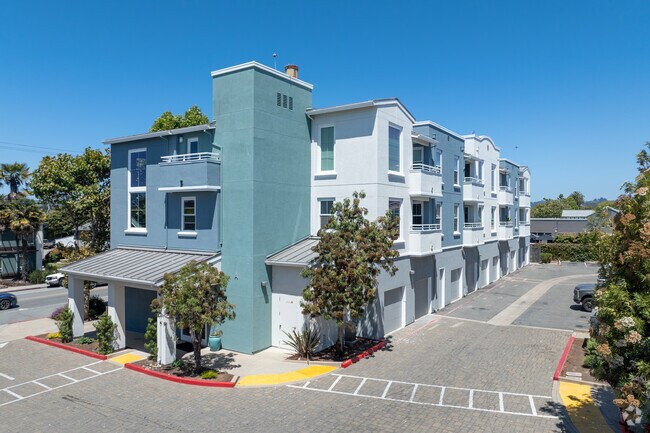
This Property Is For Sale
NEARBY LISTINGS FOR SALE OR LEASE
Property Detail
1066 41St Ave
034-721-29-000
Capitola Beach Villas T #1516
Condominium
Santa Cruz
X
California
06087C0354F
1
2024
0.02 AC
2025
Eastside
121602
Santa Cruz/Watsonville
990 SF
Santa Cruz-Watsonville, CA
DEMOGRAPHICS near 1066 41St Ave
1 mile
3 mile
5 mile
2024 Total Population
18,964
69,421
123,642
2029 Population
18,887
68,663
122,107
Pop Growth 2024-2029
(0.41%)
(1.09%)
(1.24%)
Average Age
43
44
43
2024 Total Households
8,103
29,124
50,340
HH Growth 2024-2029
(0.53%)
(1.22%)
(1.37%)
Median Household Inc
$92,372
$96,776
$100,406
Avg Household Size
2.30
2.30
2.30
2024 Avg HH Vehicles
2.00
2.00
2.00
Median Home Value
$904,822
$919,724
$1,011,278
Median Year Built
1974
1973
1972
Nearby Places
Map Layers
Map Styles
 Street
 Aerial
Transit
 Traffic
 Biking
Places
Listings with unknown addresses are not visible on the map
- Restaurants
- Banks
- Shops
- Fitness
- Groceries
PUBLIC TRANSPORTATION
AIRPORT
Norman Y Mineta San Jose International
Drive
Walk
Distance
Norman Y Mineta San Jose International
49 min
35.3 mi
Monterey Regional
Drive
Walk
Distance
Monterey Regional
50 min
39.9 mi
Nearby Properties
Address
Land Use
TOTAL SIZE
Lot Size
Zoning
Address
Land Use
TOTAL SIZE
Lot Size
Zoning
18.67 AC
PF
Address
Land Use
TOTAL SIZE
Lot Size
Zoning
135,803 SF
56.45 AC
PR
Address
Land Use
TOTAL SIZE
Lot Size
Zoning
3.46 AC
PF
Address
Land Use
TOTAL SIZE
Lot Size
Zoning
82,820 SF
4.64 AC
RM-3
Address
Land Use
TOTAL SIZE
Lot Size
Zoning
53,988 SF
2.36 AC
C-1
Address
Land Use
TOTAL SIZE
Lot Size
Zoning
133,825 SF
8.22 AC
Address
Land Use
TOTAL SIZE
Lot Size
Zoning
84,533 SF
2.62 AC
RM-2.5
Address
Land Use
TOTAL SIZE
Lot Size
Zoning
1,536 SF
15.79 AC
RM-5-MH
Address
Land Use
TOTAL SIZE
Lot Size
Zoning
50,511 SF
2.54 AC
RM-3-H
Address
Land Use
TOTAL SIZE
Lot Size
Zoning
1.46 AC
Address
Land Use
TOTAL SIZE
Lot Size
Zoning
2,571 SF
14.40 AC
C-2
Address
Land Use
TOTAL SIZE
Lot Size
Zoning
128,853 SF
3.54 AC
Address
Land Use
TOTAL SIZE
Lot Size
Zoning
5,434 SF
0.42 AC
Address
Land Use
TOTAL SIZE
Lot Size
Zoning
1,535 SF
10.11 AC
C-2
Address
Land Use
TOTAL SIZE
Lot Size
Zoning
75,000 SF
5.99 AC
Address
Land Use
TOTAL SIZE
Lot Size
Zoning
55,012 SF
6.77 AC
Address
Land Use
TOTAL SIZE
Lot Size
Zoning
19,652 SF
2.53 AC
PA
Address
Land Use
TOTAL SIZE
Lot Size
Zoning
10.05 AC
Address
Land Use
TOTAL SIZE
Lot Size
Zoning
1,356 SF
11.53 AC
RM-4-MH
Address
Land Use
TOTAL SIZE
Lot Size
Zoning
59,950 SF
1.16 AC
Address
Land Use
TOTAL SIZE
Lot Size
Zoning
66,513 SF
5.53 AC
RM-3-MH
Address
Land Use
TOTAL SIZE
Lot Size
Zoning
102,976 SF
2.06 AC
C-4
Address
Land Use
TOTAL SIZE
Lot Size
Zoning
82,075 SF
4.59 AC
Address
Land Use
TOTAL SIZE
Lot Size
Zoning
174,153 SF
3.72 AC
RM-2.5
Address
Land Use
TOTAL SIZE
Lot Size
Zoning
1,040 SF
7.25 AC
Address
Land Use
TOTAL SIZE
Lot Size
Zoning
2.59 AC
Address
Land Use
TOTAL SIZE
Lot Size
Zoning
41,289 SF
4.11 AC
C-4
Address
Land Use
TOTAL SIZE
Lot Size
Zoning
5,719 SF
0.41 AC
Address
Land Use
TOTAL SIZE
Lot Size
Zoning
52,118 SF
2.18 AC
Address
Land Use
TOTAL SIZE
Lot Size
Zoning
2,914 SF
9.70 AC
RM-4-MH
The World's #1 Commercial Real Estate Marketplace
Connect with us
© 2026 CoStar Group
The information above has been obtained from sources believed reliable. While we do not doubt its accuracy we have not verified it and make no guarantee, warranty or representation about it. It is your responsibility to independently confirm its accuracy and completeness. Any projections, opinions, assumptions, or estimates used are for example only and do not represent the current or future performance of the property. The value of this transaction to you depends on tax and other factors which should be evaluated by your tax, financial, and legal advisors. You and your advisors should conduct a careful, independent investigation of the property to determine to your satisfaction the suitability of the property for your needs.