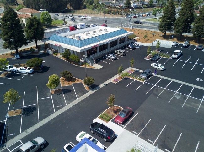
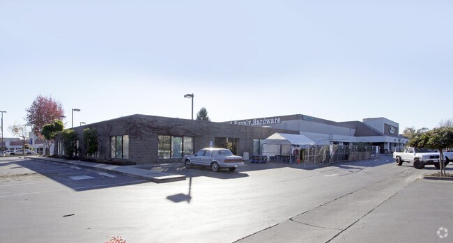
Property Record
1066 S Green Valley Rd, Watsonville, CA 95076


NEARBY LISTINGS FOR SALE OR LEASE
Property Detail
1066 S Green Valley Rd
018-281-43-000
Watsonville Boundary Adjustment Number B
Regionalshoppingcenterormallwithanchorstore
Santa Cruz
X
California
06087C0391E
5.14 AC
2024
Watsonville
2025
Santa Cruz/Watsonville
110402
Santa Cruz-Watsonville, CA
53,672 SF
DEMOGRAPHICS near 1066 S Green Valley Rd
1 Mile
3 Mile
5 Mile
2024 Total Population
16,497
61,421
77,668
2029 Population
16,078
59,539
75,217
Pop Growth 2024-2029
(2.54%)
(3.06%)
(3.16%)
Average Age
35
36
37
2024 Total Households
4,234
16,381
21,122
HH Growth 2024-2029
(2.91%)
(3.41%)
(3.50%)
Median Household Inc
$81,328
$74,582
$79,426
Avg Household Size
3.70
3.50
3.50
2024 Avg HH Vehicles
2.00
2.00
2.00
Median Home Value
$635,509
$641,896
$701,606
Median Year Built
1984
1973
1973
Nearby Places
Map Layers
Map Styles
 Street
 Aerial
- Restaurants
- Banks
- Shops
- Fitness
- Groceries
PUBLIC TRANSPORTATION
AIRPORT
Monterey Regional
DRIVE
WALK
Distance
Monterey Regional
35 min
27.8 mi
Freight Ports
Port of Redwood City
DRIVE
WALK
Distance
Port of Redwood City
79 min
61.4 mi
SALE & LEASE HISTORY
LISTING DATE
SALE/LEASE

Sep 25, 2016
For Lease
Jul 10, 2018
For Lease
Jan 10, 2020
For Lease
Dec 10, 2024
For Lease
Apr 25, 2022
For Lease
Nearby Properties
Address
Land Use
TOTAL SIZE
Lot Size
Zoning
Address
Land Use
TOTAL SIZE
Lot Size
Zoning
3,767 SF
6.90 AC
RM-2-R
Address
Land Use
TOTAL SIZE
Lot Size
Zoning
163,824 SF
13.98 AC
Address
Land Use
TOTAL SIZE
Lot Size
Zoning
155,402 SF
11.53 AC
Address
Land Use
TOTAL SIZE
Lot Size
Zoning
193,645 SF
25.70 AC
Address
Land Use
TOTAL SIZE
Lot Size
Zoning
60,392 SF
4.07 AC
RM-4
Address
Land Use
TOTAL SIZE
Lot Size
Zoning
77,449 SF
14.38 AC
R-1-6
Address
Land Use
TOTAL SIZE
Lot Size
Zoning
64,650 SF
6.04 AC
Address
Land Use
TOTAL SIZE
Lot Size
Zoning
146,574 SF
9.97 AC
Address
Land Use
TOTAL SIZE
Lot Size
Zoning
Address
Land Use
TOTAL SIZE
Lot Size
Zoning
94,674 SF
3.38 AC
Address
Land Use
TOTAL SIZE
Lot Size
Zoning
2.34 AC
Address
Land Use
TOTAL SIZE
Lot Size
Zoning
5,963 SF
7.89 AC
Address
Land Use
TOTAL SIZE
Lot Size
Zoning
373,950 SF
16.47 AC
Address
Land Use
TOTAL SIZE
Lot Size
Zoning
8.45 AC
Address
Land Use
TOTAL SIZE
Lot Size
Zoning
8.64 AC
Address
Land Use
TOTAL SIZE
Lot Size
Zoning
7.94 AC
Address
Land Use
TOTAL SIZE
Lot Size
Zoning
59,897 SF
1.54 AC
Address
Land Use
TOTAL SIZE
Lot Size
Zoning
4.59 AC
CA
Address
Land Use
TOTAL SIZE
Lot Size
Zoning
41,700 SF
3 AC
PA
Address
Land Use
TOTAL SIZE
Lot Size
Zoning
58,495 SF
1.77 AC
Address
Land Use
TOTAL SIZE
Lot Size
Zoning
10.47 AC
CAW
Address
Land Use
TOTAL SIZE
Lot Size
Zoning
Address
Land Use
TOTAL SIZE
Lot Size
Zoning
40,585 SF
2.40 AC
R-1-6
Address
Land Use
TOTAL SIZE
Lot Size
Zoning
14.98 AC
PF
Address
Land Use
TOTAL SIZE
Lot Size
Zoning
45,000 SF
1.56 AC
Address
Land Use
TOTAL SIZE
Lot Size
Zoning
64,472 SF
3.27 AC
Address
Land Use
TOTAL SIZE
Lot Size
Zoning
7.02 AC
Address
Land Use
TOTAL SIZE
Lot Size
Zoning
65,782 SF
3.60 AC
Address
Land Use
TOTAL SIZE
Lot Size
Zoning
75,884 SF
2.03 AC
The World's #1 Commercial Real Estate Marketplace
Connect with us
© 2025 CoStar Group
The information above has been obtained from sources believed reliable. While we do not doubt its accuracy we have not verified it and make no guarantee, warranty or representation about it. It is your responsibility to independently confirm its accuracy and completeness. Any projections, opinions, assumptions, or estimates used are for example only and do not represent the current or future performance of the property. The value of this transaction to you depends on tax and other factors which should be evaluated by your tax, financial, and legal advisors. You and your advisors should conduct a careful, independent investigation of the property to determine to your satisfaction the suitability of the property for your needs.