Property Record
1066 Spire Dr, Prescott, AZ 86305


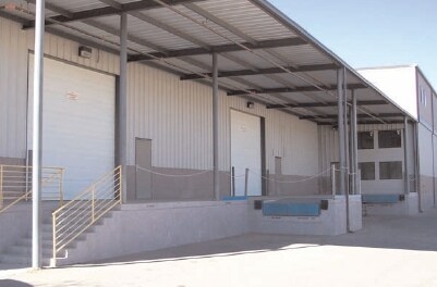

Property Detail
1066 Spire Dr
Prescott, AZ
SANDRETTO HILLS PHS II(REPLAT OF LOTS 13 & 14)LOT 13 AKA LOT 13 & A PTN OF LOT 14 SEC 10-14N-2W CONT 1.43AC
106-08-083B
Yavapai
Lightindustrial
Arizona
B and X Area of moderate flood hazard, usually the area between the limits of the 100-year and 500-year floods.
13,14
2025
1.43 AC
2027
Prescott & Sedona
000301
Other Market Areas
28,980 SF
NEARBY LISTINGS FOR SALE OR LEASE
-
-
View all Prescott listings for sale on LoopNet.com
DEMOGRAPHICS near 1066 Spire Dr
1 mile
3 mile
5 mile
2025 Total Population
3,666
24,334
49,491
2030 Population
3,909
25,743
52,534
Pop Growth 2025-2030
+ 6.63%
+ 5.79%
+ 6.15%
Average Age
52
51
51
2025 Total Households
1,843
10,824
22,999
HH Growth 2025-2030
+ 6.73%
+ 6.03%
+ 6.29%
Median Household Inc
$65,522
$80,545
$71,573
Avg Household Size
1.90
2.10
2.00
2025 Avg HH Vehicles
2.00
2.00
2.00
Median Home Value
$623,176
$617,580
$603,506
Median Year Built
2002
1999
1994
Nearby Places
Map Layers
Map Styles
 Street
 Aerial
Layers
 Traffic
 Biking
Places
Listings with unknown addresses are not visible on the map
- Restaurants
- Banks
- Shops
- Fitness
- Groceries
Nearby Properties
Address
Land Use
TOTAL SIZE
Lot Size
Zoning
Address
Land Use
TOTAL SIZE
Lot Size
Zoning
371,471 SF
24 AC
Address
Land Use
TOTAL SIZE
Lot Size
Zoning
319,895 SF
216.53 AC
Address
Land Use
TOTAL SIZE
Lot Size
Zoning
120,451 SF
7.34 AC
Address
Land Use
TOTAL SIZE
Lot Size
Zoning
84,550 SF
21.26 AC
Address
Land Use
TOTAL SIZE
Lot Size
Zoning
81,618 SF
2.77 AC
Address
Land Use
TOTAL SIZE
Lot Size
Zoning
103,185 SF
285.56 AC
Address
Land Use
TOTAL SIZE
Lot Size
Zoning
47,587 SF
5.86 AC
Address
Land Use
TOTAL SIZE
Lot Size
Zoning
46,670 SF
118.55 AC
Address
Land Use
TOTAL SIZE
Lot Size
Zoning
35,236 SF
23.97 AC
Address
Land Use
TOTAL SIZE
Lot Size
Zoning
29,166 SF
172.67 AC
Address
Land Use
TOTAL SIZE
Lot Size
Zoning
38,666 SF
9.43 AC
Address
Land Use
TOTAL SIZE
Lot Size
Zoning
65,147 SF
6.39 AC
Address
Land Use
TOTAL SIZE
Lot Size
Zoning
21,322 SF
4.96 AC
Address
Land Use
TOTAL SIZE
Lot Size
Zoning
24,356 SF
5.23 AC
Address
Land Use
TOTAL SIZE
Lot Size
Zoning
59,847 SF
10.23 AC
Address
Land Use
TOTAL SIZE
Lot Size
Zoning
46,021 SF
3.82 AC
Address
Land Use
TOTAL SIZE
Lot Size
Zoning
40,838 SF
1.96 AC
Address
Land Use
TOTAL SIZE
Lot Size
Zoning
24,519 SF
14.96 AC
Address
Land Use
TOTAL SIZE
Lot Size
Zoning
25,417 SF
3.40 AC
Address
Land Use
TOTAL SIZE
Lot Size
Zoning
23,200 SF
6.72 AC
Address
Land Use
TOTAL SIZE
Lot Size
Zoning
35,235 SF
9.63 AC
Address
Land Use
TOTAL SIZE
Lot Size
Zoning
25,760 SF
20.87 AC
Address
Land Use
TOTAL SIZE
Lot Size
Zoning
20,587 SF
19.08 AC
Address
Land Use
TOTAL SIZE
Lot Size
Zoning
38,528 SF
3.16 AC
Address
Land Use
TOTAL SIZE
Lot Size
Zoning
10,551 SF
36.11 AC
Address
Land Use
TOTAL SIZE
Lot Size
Zoning
3,000 SF
10.22 AC
Address
Land Use
TOTAL SIZE
Lot Size
Zoning
25,014 SF
8.54 AC
Address
Land Use
TOTAL SIZE
Lot Size
Zoning
13,046 SF
2.59 AC
Address
Land Use
TOTAL SIZE
Lot Size
Zoning
21,154 SF
2.43 AC
The World's #1 Commercial Real Estate Marketplace
Connect with us
© 2026 CoStar Group
The information above has been obtained from sources believed reliable. While we do not doubt its accuracy we have not verified it and make no guarantee, warranty or representation about it. It is your responsibility to independently confirm its accuracy and completeness. Any projections, opinions, assumptions, or estimates used are for example only and do not represent the current or future performance of the property. The value of this transaction to you depends on tax and other factors which should be evaluated by your tax, financial, and legal advisors. You and your advisors should conduct a careful, independent investigation of the property to determine to your satisfaction the suitability of the property for your needs.