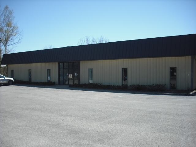
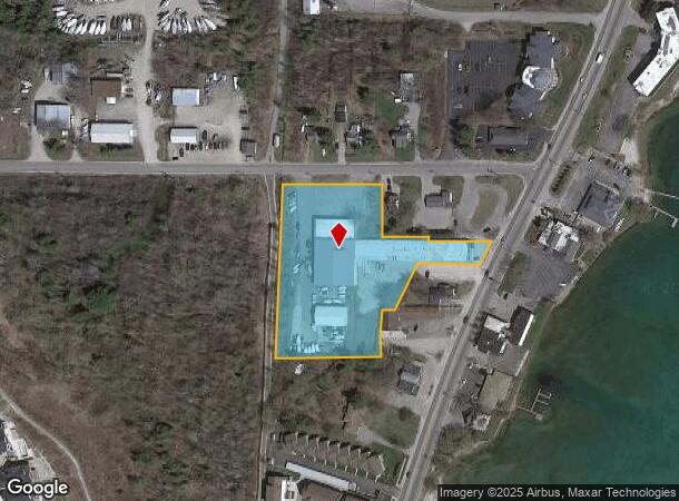
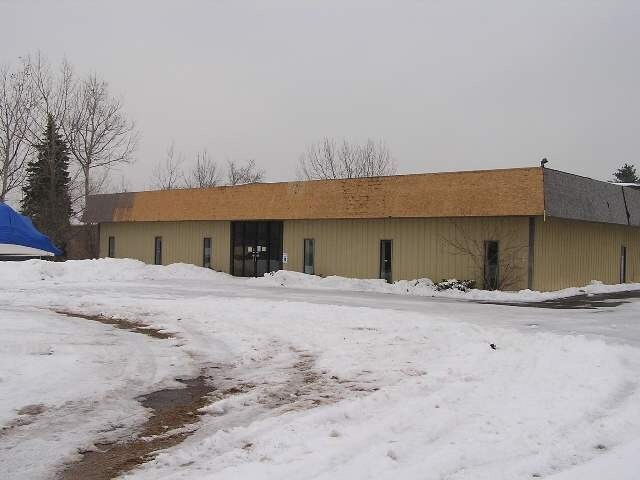
Property Record
10660 E Carter Rd, Traverse City, MI 49684
NEARBY LISTINGS FOR SALE OR LEASE
Property Detail
10660 E Carter Rd
004-033-113-00
L543 P991/00 L638 P2/02 L771 P74 L792 P383/04 2004 DESCR REVISED L1168 P965/13 L1196 P863/14 PRT GOV
Commercialnec
Leelanau
X
Michigan
26089C0519E
3
2025
3.08 AC
2025
Other Market Areas
970601
Traverse City, MI
DEMOGRAPHICS near 10660 E Carter Rd
1 Mile
3 Mile
5 Mile
2024 Total Population
2,209
18,402
40,742
2029 Population
2,299
19,058
42,109
Pop Growth 2024-2029
+ 4.07%
+ 3.56%
+ 3.36%
Average Age
46
45
44
2024 Total Households
949
8,429
18,584
HH Growth 2024-2029
+ 3.90%
+ 3.52%
+ 3.30%
Median Household Inc
$99,504
$65,263
$61,417
Avg Household Size
2.30
2.10
2.10
2024 Avg HH Vehicles
2.00
2.00
2.00
Median Home Value
$392,718
$358,704
$302,187
Median Year Built
1979
1973
1982
Nearby Places
Map Layers
Map Styles
 Street
 Aerial
- Restaurants
- Banks
- Shops
- Fitness
- Groceries
PUBLIC TRANSPORTATION
AIRPORT
Cherry Capital
DRIVE
WALK
Distance
Cherry Capital
15 min
5.5 mi
Freight Ports
Port Milwaukee
DRIVE
WALK
Distance
Port Milwaukee
467 min
405.4 mi
Nearby Properties
Address
Land Use
TOTAL SIZE
Lot Size
Zoning
Address
Land Use
TOTAL SIZE
Lot Size
Zoning
100,935 SF
35.95 AC
Address
Land Use
TOTAL SIZE
Lot Size
Zoning
Address
Land Use
TOTAL SIZE
Lot Size
Zoning
103,000 SF
4.77 AC
Address
Land Use
TOTAL SIZE
Lot Size
Zoning
192,931 SF
75.10 AC
Address
Land Use
TOTAL SIZE
Lot Size
Zoning
123,544 SF
3.93 AC
Address
Land Use
TOTAL SIZE
Lot Size
Zoning
53,806 SF
77.29 AC
Address
Land Use
TOTAL SIZE
Lot Size
Zoning
243,935 SF
28.83 AC
Address
Land Use
TOTAL SIZE
Lot Size
Zoning
75,085 SF
0.84 AC
Address
Land Use
TOTAL SIZE
Lot Size
Zoning
61,480 SF
0.49 AC
Address
Land Use
TOTAL SIZE
Lot Size
Zoning
257,342 SF
25.11 AC
Address
Land Use
TOTAL SIZE
Lot Size
Zoning
72,997 SF
0.65 AC
Address
Land Use
TOTAL SIZE
Lot Size
Zoning
78,393 SF
7.83 AC
Address
Land Use
TOTAL SIZE
Lot Size
Zoning
131,040 SF
22.23 AC
Address
Land Use
TOTAL SIZE
Lot Size
Zoning
77,000 SF
1.71 AC
Address
Land Use
TOTAL SIZE
Lot Size
Zoning
42,598 SF
2.81 AC
Address
Land Use
TOTAL SIZE
Lot Size
Zoning
Address
Land Use
TOTAL SIZE
Lot Size
Zoning
33,184 SF
0.76 AC
Address
Land Use
TOTAL SIZE
Lot Size
Zoning
139,710 SF
8.04 AC
Address
Land Use
TOTAL SIZE
Lot Size
Zoning
71,400 SF
3.69 AC
Address
Land Use
TOTAL SIZE
Lot Size
Zoning
89,143 SF
2.73 AC
Address
Land Use
TOTAL SIZE
Lot Size
Zoning
38,232 SF
0.65 AC
Address
Land Use
TOTAL SIZE
Lot Size
Zoning
28,620 SF
3.86 AC
Address
Land Use
TOTAL SIZE
Lot Size
Zoning
54,254 SF
4.83 AC
Address
Land Use
TOTAL SIZE
Lot Size
Zoning
186,482 SF
1.43 AC
Address
Land Use
TOTAL SIZE
Lot Size
Zoning
65,392 SF
1.54 AC
Address
Land Use
TOTAL SIZE
Lot Size
Zoning
65,775 SF
1.99 AC
Address
Land Use
TOTAL SIZE
Lot Size
Zoning
4,377 SF
3.90 AC
Address
Land Use
TOTAL SIZE
Lot Size
Zoning
2,216 SF
7.48 AC
Address
Land Use
TOTAL SIZE
Lot Size
Zoning
59,000 SF
46.12 AC
Address
Land Use
TOTAL SIZE
Lot Size
Zoning
40,958 SF
0.31 AC
The World's #1 Commercial Real Estate Marketplace
Connect with us
© 2026 CoStar Group
The information above has been obtained from sources believed reliable. While we do not doubt its accuracy we have not verified it and make no guarantee, warranty or representation about it. It is your responsibility to independently confirm its accuracy and completeness. Any projections, opinions, assumptions, or estimates used are for example only and do not represent the current or future performance of the property. The value of this transaction to you depends on tax and other factors which should be evaluated by your tax, financial, and legal advisors. You and your advisors should conduct a careful, independent investigation of the property to determine to your satisfaction the suitability of the property for your needs.