Property Record
10670 Cabela Dr, Lone Tree, CO 80124
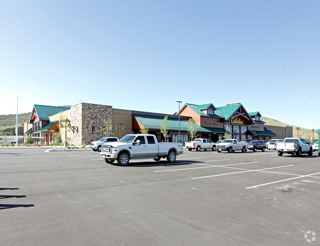
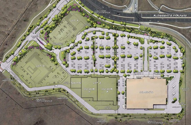
Property Detail
10670 Cabela Dr
Denver-Aurora-Centennial, CO
PART LOT 1 RIDGEGATE 18 4.581 AM/L MTD 0482329
2231-221-01-001
Douglas
Commercialnec
Colorado
B and X Area of moderate flood hazard, usually the area between the limits of the 100-year and 500-year floods.
1
2024
6.10 AC
2025
South
014115
Denver
103,788 SF
NEARBY LISTINGS FOR SALE OR LEASE
DEMOGRAPHICS near 10670 Cabela Dr
1 mile
3 mile
5 mile
2025 Total Population
5,089
52,519
173,962
2030 Population
5,527
56,676
185,355
Pop Growth 2025-2030
+ 8.61%
+ 7.92%
+ 6.55%
Average Age
39
38
39
2025 Total Households
2,307
20,820
65,405
HH Growth 2025-2030
+ 8.50%
+ 8.35%
+ 6.81%
Median Household Inc
$120,525
$132,291
$141,903
Avg Household Size
2.20
2.50
2.60
2025 Avg HH Vehicles
2.00
2.00
2.00
Median Home Value
$827,169
$787,487
$747,635
Median Year Built
2011
2008
2001
Nearby Places
Map Layers
Map Styles
 Street
 Aerial
Transit
 Traffic
 Biking
Places
Listings with unknown addresses are not visible on the map
- Restaurants
- Banks
- Shops
- Fitness
- Groceries
PUBLIC TRANSPORTATION
TRANSIT/SUBWAY
Ridgegate Parkway Station (Union Station to RidgeGate Parkway Station - Regional Transportation District)
Drive
Walk
Distance
Ridgegate Parkway Station (Union Station to RidgeGate Parkway Station - Regional Transportation District)
4 min
12 min
0.6 mi
Sky Ridge Station (Union Station to RidgeGate Parkway Station - Regional Transportation District)
Drive
Walk
Distance
Sky Ridge Station (Union Station to RidgeGate Parkway Station - Regional Transportation District)
3 min
18 min
1.0 mi
AIRPORT
Denver International
Drive
Walk
Distance
Denver International
40 min
36.1 mi
Freight Ports
Tulsa Port Of Catoosa
Drive
Walk
Distance
Tulsa Port Of Catoosa
733 min
716.0 mi
Nearby Properties
Address
Land Use
TOTAL SIZE
Lot Size
Zoning
Address
Land Use
TOTAL SIZE
Lot Size
Zoning
709,725 SF
15.21 AC
Address
Land Use
TOTAL SIZE
Lot Size
Zoning
709,725 SF
29.14 AC
Address
Land Use
TOTAL SIZE
Lot Size
Zoning
805,440 SF
28.65 AC
Address
Land Use
TOTAL SIZE
Lot Size
Zoning
260,667 SF
19.72 AC
Address
Land Use
TOTAL SIZE
Lot Size
Zoning
1,630,979 SF
32.01 AC
Address
Land Use
TOTAL SIZE
Lot Size
Zoning
364,806 SF
75.76 AC
PDU
Address
Land Use
TOTAL SIZE
Lot Size
Zoning
162,758 SF
11.21 AC
Address
Land Use
TOTAL SIZE
Lot Size
Zoning
621,565 SF
32.64 AC
PDU
Address
Land Use
TOTAL SIZE
Lot Size
Zoning
163,443 SF
14.39 AC
Address
Land Use
TOTAL SIZE
Lot Size
Zoning
650,416 SF
33.37 AC
LI
Address
Land Use
TOTAL SIZE
Lot Size
Zoning
661,139 SF
Address
Land Use
TOTAL SIZE
Lot Size
Zoning
128,812 SF
2.55 AC
Address
Land Use
TOTAL SIZE
Lot Size
Zoning
418,258 SF
14.46 AC
PDU
Address
Land Use
TOTAL SIZE
Lot Size
Zoning
126,202 SF
2.27 AC
Address
Land Use
TOTAL SIZE
Lot Size
Zoning
112,021 SF
3.17 AC
Address
Land Use
TOTAL SIZE
Lot Size
Zoning
494,862 SF
30.59 AC
PDU
Address
Land Use
TOTAL SIZE
Lot Size
Zoning
632,485 SF
38.43 AC
PDU
Address
Land Use
TOTAL SIZE
Lot Size
Zoning
181,361 SF
549.62 AC
Address
Land Use
TOTAL SIZE
Lot Size
Zoning
651,701 SF
10.77 AC
PDU
Address
Land Use
TOTAL SIZE
Lot Size
Zoning
187,757 SF
7.47 AC
Address
Land Use
TOTAL SIZE
Lot Size
Zoning
122,017 SF
11.39 AC
PDU
Address
Land Use
TOTAL SIZE
Lot Size
Zoning
89,546 SF
9.55 AC
SR
Address
Land Use
TOTAL SIZE
Lot Size
Zoning
99,678 SF
10.25 AC
Address
Land Use
TOTAL SIZE
Lot Size
Zoning
324,829 SF
20.45 AC
SR
Address
Land Use
TOTAL SIZE
Lot Size
Zoning
80,178 SF
4.85 AC
Address
Land Use
TOTAL SIZE
Lot Size
Zoning
277,142 SF
17.74 AC
PDU
Address
Land Use
TOTAL SIZE
Lot Size
Zoning
196,390 SF
13.10 AC
Address
Land Use
TOTAL SIZE
Lot Size
Zoning
172,792 SF
16.48 AC
LI
Address
Land Use
TOTAL SIZE
Lot Size
Zoning
87,947 SF
5.42 AC
Address
Land Use
TOTAL SIZE
Lot Size
Zoning
146,965 SF
30.93 AC
The World's #1 Commercial Real Estate Marketplace
Connect with us
© 2026 CoStar Group
The information above has been obtained from sources believed reliable. While we do not doubt its accuracy we have not verified it and make no guarantee, warranty or representation about it. It is your responsibility to independently confirm its accuracy and completeness. Any projections, opinions, assumptions, or estimates used are for example only and do not represent the current or future performance of the property. The value of this transaction to you depends on tax and other factors which should be evaluated by your tax, financial, and legal advisors. You and your advisors should conduct a careful, independent investigation of the property to determine to your satisfaction the suitability of the property for your needs.