Property Record
10670 State Highway 10, Clinton, IL 61727
NEARBY LISTINGS FOR SALE OR LEASE
-
-
View all Clinton listings for lease on LoopNet.com
Property Detail
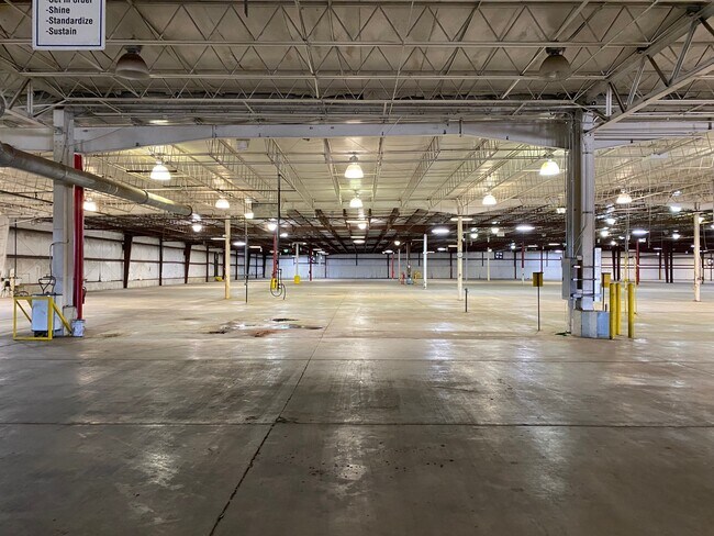
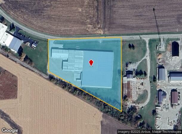
10670 State Highway 10
12-02-200-012
Te - Section 02
Industrialgeneral
S2 T19 R2, PT N 1/2 NE - BEG NW COR NE NE, E200.07, S711, NW839.55, N313.4, E539.59 TO POB
X
De Witt
17039C0215E
Illinois
2024
8.32 AC
2024
Illinois North Area
971500
Other Market Areas
13,440 SF
Bloomington, IL
DEMOGRAPHICS near 10670 State Highway 10
1 Mile
3 Mile
5 Mile
2024 Total Population
1,202
8,274
9,068
2029 Population
1,189
8,137
8,900
Pop Growth 2024-2029
(1.08%)
(1.66%)
(1.85%)
Average Age
40
41
41
2024 Total Households
524
3,592
3,913
HH Growth 2024-2029
(1.15%)
(1.64%)
(1.84%)
Median Household Inc
$56,078
$53,147
$54,816
Avg Household Size
2.10
2.20
2.20
2024 Avg HH Vehicles
2.00
2.00
2.00
Median Home Value
$82,425
$94,409
$100,406
Median Year Built
1967
1958
1960
Nearby Places
Map Layers
Map Styles
 Street
 Aerial
- Restaurants
- Banks
- Shops
- Fitness
- Groceries
PUBLIC TRANSPORTATION
AIRPORT
Central Il Regional/Bloomington-Normal
DRIVE
WALK
Distance
Central Il Regional/Bloomington-Normal
46 min
29.8 mi
Freight Ports
Port Milwaukee
DRIVE
WALK
Distance
Port Milwaukee
276 min
236.4 mi
SALE & LEASE HISTORY
LISTING DATE
SALE/LEASE

Mar 28, 2022
For Lease
Nearby Properties
Address
Land Use
TOTAL SIZE
Lot Size
Zoning
Address
Land Use
TOTAL SIZE
Lot Size
Zoning
446.13 AC
Address
Land Use
TOTAL SIZE
Lot Size
Zoning
59.49 AC
Address
Land Use
TOTAL SIZE
Lot Size
Zoning
7.40 AC
Address
Land Use
TOTAL SIZE
Lot Size
Zoning
23,034 SF
5.46 AC
Address
Land Use
TOTAL SIZE
Lot Size
Zoning
14,400 SF
5.83 AC
Address
Land Use
TOTAL SIZE
Lot Size
Zoning
8,896 SF
1.54 AC
Address
Land Use
TOTAL SIZE
Lot Size
Zoning
19.04 AC
Address
Land Use
TOTAL SIZE
Lot Size
Zoning
42,750 SF
14.57 AC
Address
Land Use
TOTAL SIZE
Lot Size
Zoning
653,182 SF
34.16 AC
Address
Land Use
TOTAL SIZE
Lot Size
Zoning
34,875 SF
4.33 AC
Address
Land Use
TOTAL SIZE
Lot Size
Zoning
10,077 SF
1.73 AC
Address
Land Use
TOTAL SIZE
Lot Size
Zoning
Address
Land Use
TOTAL SIZE
Lot Size
Zoning
28,800 SF
6.18 AC
Address
Land Use
TOTAL SIZE
Lot Size
Zoning
4,184 SF
1.41 AC
Address
Land Use
TOTAL SIZE
Lot Size
Zoning
6.29 AC
Address
Land Use
TOTAL SIZE
Lot Size
Zoning
27,690 SF
2.37 AC
Address
Land Use
TOTAL SIZE
Lot Size
Zoning
18,876 SF
0.81 AC
Address
Land Use
TOTAL SIZE
Lot Size
Zoning
20,825 SF
4.71 AC
Address
Land Use
TOTAL SIZE
Lot Size
Zoning
61,900 SF
1.65 AC
Address
Land Use
TOTAL SIZE
Lot Size
Zoning
12,480 SF
2.08 AC
Address
Land Use
TOTAL SIZE
Lot Size
Zoning
3,486 SF
1.07 AC
Address
Land Use
TOTAL SIZE
Lot Size
Zoning
0.53 AC
Address
Land Use
TOTAL SIZE
Lot Size
Zoning
29,269 SF
4.25 AC
Address
Land Use
TOTAL SIZE
Lot Size
Zoning
0.37 AC
Address
Land Use
TOTAL SIZE
Lot Size
Zoning
4,416 SF
1.21 AC
Address
Land Use
TOTAL SIZE
Lot Size
Zoning
30,382 SF
3.01 AC
Address
Land Use
TOTAL SIZE
Lot Size
Zoning
9,283 SF
1.73 AC
Address
Land Use
TOTAL SIZE
Lot Size
Zoning
2,889 SF
0.70 AC
Address
Land Use
TOTAL SIZE
Lot Size
Zoning
12,988 SF
1.64 AC
The World's #1 Commercial Real Estate Marketplace
Connect with us
© 2025 CoStar Group
The information above has been obtained from sources believed reliable. While we do not doubt its accuracy we have not verified it and make no guarantee, warranty or representation about it. It is your responsibility to independently confirm its accuracy and completeness. Any projections, opinions, assumptions, or estimates used are for example only and do not represent the current or future performance of the property. The value of this transaction to you depends on tax and other factors which should be evaluated by your tax, financial, and legal advisors. You and your advisors should conduct a careful, independent investigation of the property to determine to your satisfaction the suitability of the property for your needs.