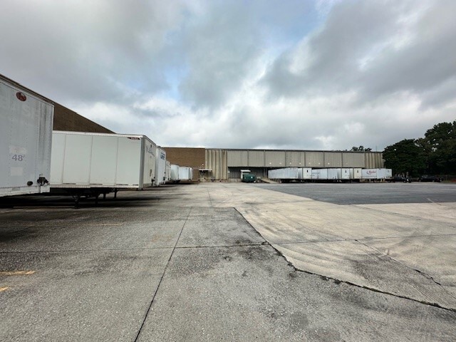
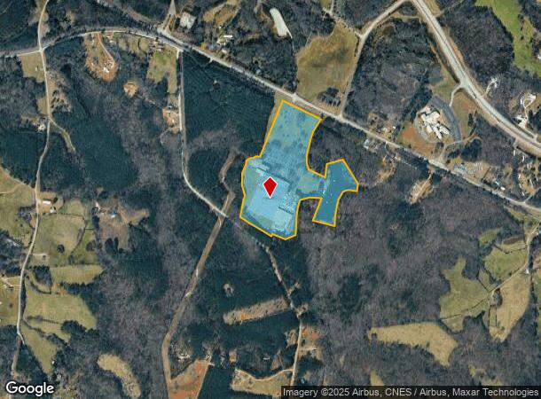
Property Record
1068 Historic Highway 17, Toccoa, GA 30577
NEARBY LISTINGS FOR SALE OR LEASE
Property Detail
1068 Historic Highway 17
061-026
8400 - Wet Land - Ac
Manufacturinglight
PT TRACTS 1 & 2 HWY 17 S
A
Stephens
13119C0025C
Georgia
2025
40.32 AC
2025
Georgia Northeast
970402
Other Market Areas
154,176 SF
Toccoa, GA
DEMOGRAPHICS near 1068 Historic Highway 17
1 Mile
3 Mile
5 Mile
2024 Total Population
148
2,842
8,107
2029 Population
153
2,930
8,389
Pop Growth 2024-2029
+ 3.38%
+ 3.10%
+ 3.48%
Average Age
43
42
42
2024 Total Households
59
1,102
3,140
HH Growth 2024-2029
+ 3.39%
+ 2.72%
+ 3.22%
Median Household Inc
$65,192
$48,004
$49,166
Avg Household Size
2.40
2.60
2.50
2024 Avg HH Vehicles
3.00
3.00
2.00
Median Home Value
$95,651
$120,000
$137,959
Median Year Built
1990
1990
1989
Nearby Places
Map Layers
Map Styles
 Street
 Aerial
- Restaurants
- Banks
- Shops
- Fitness
- Groceries
PUBLIC TRANSPORTATION
COMMUTER RAIL
Toccoa Amtrak Station (Crescent - Amtrak)
DRIVE
WALK
Distance
Toccoa Amtrak Station (Crescent - Amtrak)
12 min
8.8 mi
Freight Ports
Georgia Ports - Savannah
DRIVE
WALK
Distance
Georgia Ports - Savannah
293 min
238.6 mi
Nearby Properties
Address
Land Use
TOTAL SIZE
Lot Size
Zoning
Address
Land Use
TOTAL SIZE
Lot Size
Zoning
215,538 SF
32.32 AC
CI
Address
Land Use
TOTAL SIZE
Lot Size
Zoning
53,410 SF
48.44 AC
CG
Address
Land Use
TOTAL SIZE
Lot Size
Zoning
75,274 SF
39.40 AC
CG
Address
Land Use
TOTAL SIZE
Lot Size
Zoning
109,260 SF
10.53 AC
CI
Address
Land Use
TOTAL SIZE
Lot Size
Zoning
5,100 SF
5.75 AC
CI
Address
Land Use
TOTAL SIZE
Lot Size
Zoning
4,000 SF
4 AC
CI
Address
Land Use
TOTAL SIZE
Lot Size
Zoning
Address
Land Use
TOTAL SIZE
Lot Size
Zoning
261.89 AC
UNZONED RU
Address
Land Use
TOTAL SIZE
Lot Size
Zoning
82,335 SF
6.79 AC
CI
Address
Land Use
TOTAL SIZE
Lot Size
Zoning
30,000 SF
71.21 AC
AI
Address
Land Use
TOTAL SIZE
Lot Size
Zoning
400 SF
95 AC
UNZONED RU
Address
Land Use
TOTAL SIZE
Lot Size
Zoning
30,000 SF
59.30 AC
AI
Address
Land Use
TOTAL SIZE
Lot Size
Zoning
177.71 AC
UNZONED RU
Address
Land Use
TOTAL SIZE
Lot Size
Zoning
134.39 AC
UNZONED RU
Address
Land Use
TOTAL SIZE
Lot Size
Zoning
Address
Land Use
TOTAL SIZE
Lot Size
Zoning
2,887 SF
8.40 AC
RS
Address
Land Use
TOTAL SIZE
Lot Size
Zoning
9,464 SF
4.24 AC
CG
Address
Land Use
TOTAL SIZE
Lot Size
Zoning
88.14 AC
CI
Address
Land Use
TOTAL SIZE
Lot Size
Zoning
94.33 AC
UNZONED RU
Address
Land Use
TOTAL SIZE
Lot Size
Zoning
19,195 SF
13.74 AC
CI
Address
Land Use
TOTAL SIZE
Lot Size
Zoning
4,020 SF
29.32 AC
CG
Address
Land Use
TOTAL SIZE
Lot Size
Zoning
25,000 SF
28.98 AC
AI
Address
Land Use
TOTAL SIZE
Lot Size
Zoning
800 SF
16 AC
CI
Address
Land Use
TOTAL SIZE
Lot Size
Zoning
28.90 AC
RM
Address
Land Use
TOTAL SIZE
Lot Size
Zoning
5,600 SF
5.44 AC
CG
Address
Land Use
TOTAL SIZE
Lot Size
Zoning
15,000 SF
2.44 AC
CG
Address
Land Use
TOTAL SIZE
Lot Size
Zoning
265.79 AC
AR
Address
Land Use
TOTAL SIZE
Lot Size
Zoning
1,388 SF
23.52 AC
AR
Address
Land Use
TOTAL SIZE
Lot Size
Zoning
17.85 AC
CI
The World's #1 Commercial Real Estate Marketplace
Connect with us
© 2026 CoStar Group
The information above has been obtained from sources believed reliable. While we do not doubt its accuracy we have not verified it and make no guarantee, warranty or representation about it. It is your responsibility to independently confirm its accuracy and completeness. Any projections, opinions, assumptions, or estimates used are for example only and do not represent the current or future performance of the property. The value of this transaction to you depends on tax and other factors which should be evaluated by your tax, financial, and legal advisors. You and your advisors should conduct a careful, independent investigation of the property to determine to your satisfaction the suitability of the property for your needs.