Property Record
10680 Colonial Blvd, Fort Myers, FL 33913

NEARBY LISTINGS FOR SALE OR LEASE
Property Detail
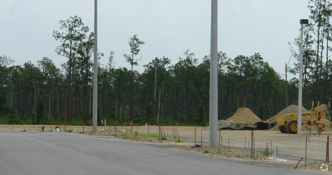
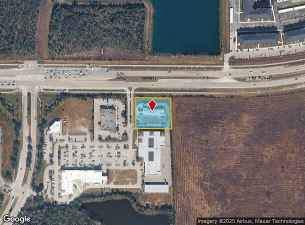
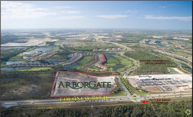
10680 Colonial Blvd
35-44-25-P2-03500.0030
Colonial - Sr 82 E Of I-75
Servicestation
ARBORGATE DESC IN INST #2007000319643 TRACT 3
AE
Lee
12071C0432F
Florida
2024
1.24 AC
2025
S Ft Myers/San Carlos
040128
Southwest Florida
6,710 SF
Cape Coral-Fort Myers, FL
DEMOGRAPHICS near 10680 Colonial Blvd
1 Mile
3 Mile
5 Mile
2024 Total Population
2,424
45,300
122,798
2029 Population
2,941
54,143
146,386
Pop Growth 2024-2029
+ 21.33%
+ 19.52%
+ 19.21%
Average Age
59
44
41
2024 Total Households
1,145
17,941
46,036
HH Growth 2024-2029
+ 21.05%
+ 19.88%
+ 19.24%
Median Household Inc
$82,527
$74,159
$65,410
Avg Household Size
2.00
2.30
2.50
2024 Avg HH Vehicles
1.00
2.00
2.00
Median Home Value
$362,591
$316,266
$288,028
Median Year Built
2009
2007
2004
Nearby Places
Map Layers
Map Styles
 Street
 Aerial
- Restaurants
- Banks
- Shops
- Fitness
- Groceries
PUBLIC TRANSPORTATION
AIRPORT
Southwest Florida International
DRIVE
WALK
Distance
Southwest Florida International
15 min
7.6 mi
Punta Gorda
DRIVE
WALK
Distance
Punta Gorda
35 min
28.5 mi
Freight Ports
Port Manatee
DRIVE
WALK
Distance
Port Manatee
115 min
100.2 mi
Nearby Properties
Address
Land Use
TOTAL SIZE
Lot Size
Zoning
Address
Land Use
TOTAL SIZE
Lot Size
Zoning
608,522 SF
38.57 AC
CG
Address
Land Use
TOTAL SIZE
Lot Size
Zoning
438,839 SF
66.95 AC
MU
Address
Land Use
TOTAL SIZE
Lot Size
Zoning
463,722 SF
23.85 AC
C-1
Address
Land Use
TOTAL SIZE
Lot Size
Zoning
362,391 SF
12.80 AC
SDA
Address
Land Use
TOTAL SIZE
Lot Size
Zoning
475,045 SF
30.22 AC
PUD
Address
Land Use
TOTAL SIZE
Lot Size
Zoning
24.69 AC
C-1
Address
Land Use
TOTAL SIZE
Lot Size
Zoning
432,890 SF
18.88 AC
SDA
Address
Land Use
TOTAL SIZE
Lot Size
Zoning
422,099 SF
1.10 AC
CG
Address
Land Use
TOTAL SIZE
Lot Size
Zoning
286,629 SF
13.01 AC
SDA
Address
Land Use
TOTAL SIZE
Lot Size
Zoning
16.13 AC
Address
Land Use
TOTAL SIZE
Lot Size
Zoning
111.70 AC
C1
Address
Land Use
TOTAL SIZE
Lot Size
Zoning
425,658 SF
25.61 AC
CG
Address
Land Use
TOTAL SIZE
Lot Size
Zoning
694,188 SF
22.43 AC
PUD
Address
Land Use
TOTAL SIZE
Lot Size
Zoning
580,121 SF
61.83 AC
IL
Address
Land Use
TOTAL SIZE
Lot Size
Zoning
324,346 SF
20 AC
C1
Address
Land Use
TOTAL SIZE
Lot Size
Zoning
9.07 AC
SDA
Address
Land Use
TOTAL SIZE
Lot Size
Zoning
17.50 AC
C1
Address
Land Use
TOTAL SIZE
Lot Size
Zoning
260,320 SF
8.81 AC
SDA
Address
Land Use
TOTAL SIZE
Lot Size
Zoning
333,614 SF
294.30 AC
AG-2
Address
Land Use
TOTAL SIZE
Lot Size
Zoning
261,340 SF
9.07 AC
CG
Address
Land Use
TOTAL SIZE
Lot Size
Zoning
6.99 AC
C-1
Address
Land Use
TOTAL SIZE
Lot Size
Zoning
288,358 SF
23.15 AC
CG
Address
Land Use
TOTAL SIZE
Lot Size
Zoning
6.38 AC
SDA
Address
Land Use
TOTAL SIZE
Lot Size
Zoning
67.46 AC
C1
Address
Land Use
TOTAL SIZE
Lot Size
Zoning
10.16 AC
MDP-3
Address
Land Use
TOTAL SIZE
Lot Size
Zoning
154,653 SF
11.77 AC
SDA
Address
Land Use
TOTAL SIZE
Lot Size
Zoning
230,967 SF
8.31 AC
SDA
Address
Land Use
TOTAL SIZE
Lot Size
Zoning
482,282 SF
20 AC
CG
Address
Land Use
TOTAL SIZE
Lot Size
Zoning
2.33 AC
CG
Address
Land Use
TOTAL SIZE
Lot Size
Zoning
231,360 SF
17.08 AC
PUD
The World's #1 Commercial Real Estate Marketplace
Connect with us
© 2026 CoStar Group
The information above has been obtained from sources believed reliable. While we do not doubt its accuracy we have not verified it and make no guarantee, warranty or representation about it. It is your responsibility to independently confirm its accuracy and completeness. Any projections, opinions, assumptions, or estimates used are for example only and do not represent the current or future performance of the property. The value of this transaction to you depends on tax and other factors which should be evaluated by your tax, financial, and legal advisors. You and your advisors should conduct a careful, independent investigation of the property to determine to your satisfaction the suitability of the property for your needs.