Property Record
10681 Highway 36, Covington, GA 30014
NEARBY LISTINGS FOR SALE OR LEASE
-
-
View all Covington listings for sale on LoopNet.com
Property Detail
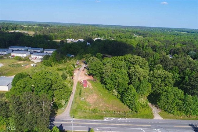
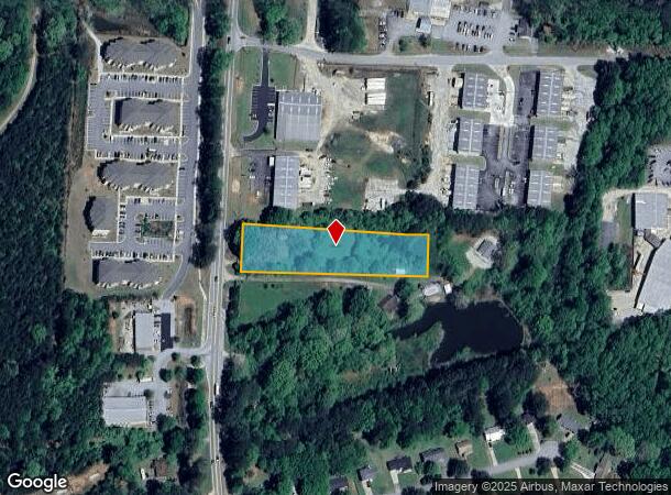
10681 Highway 36
Atlanta-Sandy Springs-Roswell, GA
R3 Misc Land - Area 7
0084000000002000
Newton
Sfr
Georgia
X
2 AC
13217C0136D
Newton County
1,122 SF
Atlanta
DEMOGRAPHICS near 10681 Highway 36
1 Mile
3 Mile
5 Mile
2024 Total Population
2,936
20,874
46,927
2029 Population
3,251
23,310
52,209
Pop Growth 2024-2029
+ 10.73%
+ 11.67%
+ 11.26%
Average Age
37
38
38
2024 Total Households
1,063
7,861
16,929
HH Growth 2024-2029
+ 11.19%
+ 12.00%
+ 11.58%
Median Household Inc
$75,045
$79,374
$74,380
Avg Household Size
2.70
2.60
2.70
2024 Avg HH Vehicles
2.00
2.00
2.00
Median Home Value
$149,019
$191,229
$186,375
Median Year Built
1995
1992
1995
Nearby Places
Map Layers
Map Styles
 Street
 Aerial
- Restaurants
- Banks
- Shops
- Fitness
- Groceries
SALE & LEASE HISTORY
LISTING DATE
SALE/LEASE

Sep 23, 2019
For Sale
Oct 20, 2020
For Sale
Oct 20, 2020
For Sale
Aug 14, 2020
For Sale
Nearby Properties
Address
Land Use
TOTAL SIZE
Lot Size
Zoning
Address
Land Use
TOTAL SIZE
Lot Size
Zoning
207,237 SF
10.61 AC
E1
Address
Land Use
TOTAL SIZE
Lot Size
Zoning
258,254 SF
15.08 AC
C1
Address
Land Use
TOTAL SIZE
Lot Size
Zoning
6,664 SF
17.75 AC
Address
Land Use
TOTAL SIZE
Lot Size
Zoning
19,292 SF
8.20 AC
H1
Address
Land Use
TOTAL SIZE
Lot Size
Zoning
88,944 SF
0.98 AC
E1
Address
Land Use
TOTAL SIZE
Lot Size
Zoning
10,000 SF
0.01 AC
Address
Land Use
TOTAL SIZE
Lot Size
Zoning
1,627 SF
16.62 AC
C1
Address
Land Use
TOTAL SIZE
Lot Size
Zoning
14,080 SF
10 AC
C1
Address
Land Use
TOTAL SIZE
Lot Size
Zoning
28,790 SF
3.70 AC
E1
Address
Land Use
TOTAL SIZE
Lot Size
Zoning
48,144 SF
1.50 AC
E1
Address
Land Use
TOTAL SIZE
Lot Size
Zoning
159,034 SF
68.30 AC
E6
Address
Land Use
TOTAL SIZE
Lot Size
Zoning
31,376 SF
3.50 AC
PUD
Address
Land Use
TOTAL SIZE
Lot Size
Zoning
41,772 SF
28.03 AC
E6
Address
Land Use
TOTAL SIZE
Lot Size
Zoning
28,512 SF
0.52 AC
Address
Land Use
TOTAL SIZE
Lot Size
Zoning
69,487 SF
18.83 AC
C1
Address
Land Use
TOTAL SIZE
Lot Size
Zoning
3,128 SF
5.68 AC
C1
Address
Land Use
TOTAL SIZE
Lot Size
Zoning
27,492 SF
0.47 AC
Address
Land Use
TOTAL SIZE
Lot Size
Zoning
74,713 SF
2.83 AC
Address
Land Use
TOTAL SIZE
Lot Size
Zoning
101,010 SF
42.72 AC
E6
Address
Land Use
TOTAL SIZE
Lot Size
Zoning
61,638 SF
0.64 AC
Address
Land Use
TOTAL SIZE
Lot Size
Zoning
63,914 SF
7.04 AC
COMMERCIAL
Address
Land Use
TOTAL SIZE
Lot Size
Zoning
150,006 SF
8.89 AC
Address
Land Use
TOTAL SIZE
Lot Size
Zoning
25,100 SF
5.47 AC
Address
Land Use
TOTAL SIZE
Lot Size
Zoning
84,356 SF
10.12 AC
Address
Land Use
TOTAL SIZE
Lot Size
Zoning
61,534 SF
7.08 AC
C1
Address
Land Use
TOTAL SIZE
Lot Size
Zoning
12,812 SF
0.17 AC
E1
Address
Land Use
TOTAL SIZE
Lot Size
Zoning
44,330 SF
1.09 AC
E2
Address
Land Use
TOTAL SIZE
Lot Size
Zoning
16,684 SF
3.96 AC
C1
Address
Land Use
TOTAL SIZE
Lot Size
Zoning
65,360 SF
20 AC
E6
Address
Land Use
TOTAL SIZE
Lot Size
Zoning
60,348 SF
7.33 AC
C1
The World's #1 Commercial Real Estate Marketplace
Connect with us
© 2025 CoStar Group
The information above has been obtained from sources believed reliable. While we do not doubt its accuracy we have not verified it and make no guarantee, warranty or representation about it. It is your responsibility to independently confirm its accuracy and completeness. Any projections, opinions, assumptions, or estimates used are for example only and do not represent the current or future performance of the property. The value of this transaction to you depends on tax and other factors which should be evaluated by your tax, financial, and legal advisors. You and your advisors should conduct a careful, independent investigation of the property to determine to your satisfaction the suitability of the property for your needs.