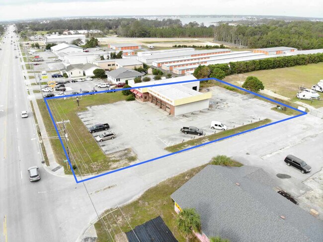
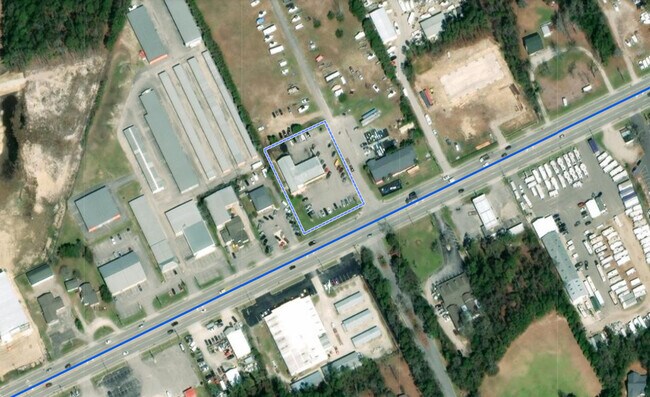
Property Record
1069 Cedar Point Blvd, Cedar Point, NC 28584

Property Detail
1069 Cedar Point Blvd
Morehead City, NC
L1 CEDAR POINT PH1 COMMERCIAL PARK
5374.11.65.4511000
Carteret
Storebuilding
North Carolina
B and X Area of moderate flood hazard, usually the area between the limits of the 100-year and 500-year floods.
1
2025
1.01 AC
2025
Coastal Carolina
970806
Other Market Areas
6,816 SF
NEARBY LISTINGS FOR SALE OR LEASE
-
-
View all Cedar Point listings for sale on LoopNet.com
DEMOGRAPHICS near 1069 Cedar Point Blvd
1 mile
3 mile
5 mile
2025 Total Population
1,911
11,347
21,672
2030 Population
2,024
11,992
23,122
Pop Growth 2025-2030
+ 5.91%
+ 5.68%
+ 6.69%
Average Age
46
47
46
2025 Total Households
807
4,968
9,314
HH Growth 2025-2030
+ 5.95%
+ 5.90%
+ 6.88%
Median Household Inc
$79,861
$85,595
$88,196
Avg Household Size
2.40
2.30
2.30
2025 Avg HH Vehicles
2.00
2.00
2.00
Median Home Value
$398,076
$404,129
$388,436
Median Year Built
2001
1994
1996
Nearby Places
Map Layers
Map Styles
 Street
 Aerial
Transit
 Traffic
 Biking
Places
Listings with unknown addresses are not visible on the map
- Restaurants
- Banks
- Shops
- Fitness
- Groceries
PUBLIC TRANSPORTATION
AIRPORT
Albert J Ellis
Drive
Walk
Distance
Albert J Ellis
61 min
35.9 mi
Coastal Carolina Regional
Drive
Walk
Distance
Coastal Carolina Regional
62 min
37.3 mi
Freight Ports
Port of Morehead City
Drive
Walk
Distance
Port of Morehead City
35 min
22.4 mi
SALE & LEASE HISTORY
LISTING DATE
SALE/LEASE

Nov 04, 2020
For Sale
Nearby Properties
Address
Land Use
TOTAL SIZE
Lot Size
Zoning
Address
Land Use
TOTAL SIZE
Lot Size
Zoning
5,952 SF
18.03 AC
Address
Land Use
TOTAL SIZE
Lot Size
Zoning
184,862 SF
11.40 AC
Address
Land Use
TOTAL SIZE
Lot Size
Zoning
10,071 SF
9.13 AC
Address
Land Use
TOTAL SIZE
Lot Size
Zoning
82,345 SF
21.69 AC
Address
Land Use
TOTAL SIZE
Lot Size
Zoning
60,867 SF
11.83 AC
Address
Land Use
TOTAL SIZE
Lot Size
Zoning
3,600 SF
30.42 AC
Address
Land Use
TOTAL SIZE
Lot Size
Zoning
6,000 SF
6.80 AC
Address
Land Use
TOTAL SIZE
Lot Size
Zoning
Address
Land Use
TOTAL SIZE
Lot Size
Zoning
44,906 SF
4.27 AC
Address
Land Use
TOTAL SIZE
Lot Size
Zoning
41,517 SF
30.20 AC
Address
Land Use
TOTAL SIZE
Lot Size
Zoning
16,048 SF
1.62 AC
Address
Land Use
TOTAL SIZE
Lot Size
Zoning
35,101 SF
3.33 AC
Address
Land Use
TOTAL SIZE
Lot Size
Zoning
10,377 SF
3.83 AC
B-2
Address
Land Use
TOTAL SIZE
Lot Size
Zoning
Address
Land Use
TOTAL SIZE
Lot Size
Zoning
27,666 SF
1.37 AC
Address
Land Use
TOTAL SIZE
Lot Size
Zoning
Address
Land Use
TOTAL SIZE
Lot Size
Zoning
37,992 SF
4.06 AC
Address
Land Use
TOTAL SIZE
Lot Size
Zoning
39,015 SF
4.45 AC
Address
Land Use
TOTAL SIZE
Lot Size
Zoning
110,331 SF
4.14 AC
Address
Land Use
TOTAL SIZE
Lot Size
Zoning
11,900 SF
1.46 AC
Address
Land Use
TOTAL SIZE
Lot Size
Zoning
30,908 SF
1.03 AC
Address
Land Use
TOTAL SIZE
Lot Size
Zoning
37,651 SF
21.92 AC
PUD
Address
Land Use
TOTAL SIZE
Lot Size
Zoning
7,400 SF
3.98 AC
B-2
Address
Land Use
TOTAL SIZE
Lot Size
Zoning
34,412 SF
3.88 AC
Address
Land Use
TOTAL SIZE
Lot Size
Zoning
36,989 SF
6.81 AC
Address
Land Use
TOTAL SIZE
Lot Size
Zoning
63,781 SF
3.09 AC
B-1
Address
Land Use
TOTAL SIZE
Lot Size
Zoning
7,642 SF
3.16 AC
Address
Land Use
TOTAL SIZE
Lot Size
Zoning
24,800 SF
2.79 AC
G/E
Address
Land Use
TOTAL SIZE
Lot Size
Zoning
19,216 SF
6.36 AC
Address
Land Use
TOTAL SIZE
Lot Size
Zoning
4,040 SF
25.69 AC
The World's #1 Commercial Real Estate Marketplace
Connect with us
© 2026 CoStar Group
The information above has been obtained from sources believed reliable. While we do not doubt its accuracy we have not verified it and make no guarantee, warranty or representation about it. It is your responsibility to independently confirm its accuracy and completeness. Any projections, opinions, assumptions, or estimates used are for example only and do not represent the current or future performance of the property. The value of this transaction to you depends on tax and other factors which should be evaluated by your tax, financial, and legal advisors. You and your advisors should conduct a careful, independent investigation of the property to determine to your satisfaction the suitability of the property for your needs.