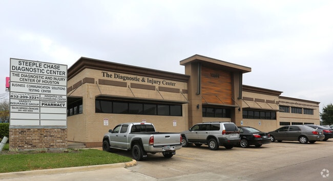
Property Record
10694 Jones Rd, Houston, TX 77065

NEARBY LISTINGS FOR SALE OR LEASE
Property Detail
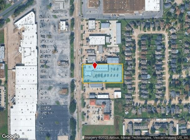
10694 Jones Rd
0432190000012
Abst 553 F Mcnaughton
Medicalbuilding
TR 2B ABST 553 F MCNAUGHTON
X
Harris
48201C0440N
Texas
2024
2 AC
2025
FM 1960/Hwy 249
551602
Houston
39,218 SF
Houston-The Woodlands-Sugar Land, TX
DEMOGRAPHICS near 10694 Jones Rd
1 Mile
3 Mile
5 Mile
2024 Total Population
13,027
107,934
248,251
2029 Population
13,218
109,396
251,366
Pop Growth 2024-2029
+ 1.47%
+ 1.35%
+ 1.25%
Average Age
39
37
38
2024 Total Households
4,507
39,962
90,543
HH Growth 2024-2029
+ 1.53%
+ 1.25%
+ 1.23%
Median Household Inc
$59,975
$67,210
$74,354
Avg Household Size
2.80
2.60
2.70
2024 Avg HH Vehicles
2.00
2.00
2.00
Median Home Value
$190,629
$222,264
$239,671
Median Year Built
1987
1992
1993
Nearby Places
Map Layers
Map Styles
 Street
 Aerial
- Restaurants
- Banks
- Shops
- Fitness
- Groceries
PUBLIC TRANSPORTATION
AIRPORT
George Bush Intcntl/Houston
DRIVE
WALK
Distance
George Bush Intcntl/Houston
26 min
19.2 mi
William P Hobby
DRIVE
WALK
Distance
William P Hobby
53 min
34.2 mi
Freight Ports
Port of Houston
DRIVE
WALK
Distance
Port of Houston
44 min
29.8 mi
SALE & LEASE HISTORY
LISTING DATE
SALE/LEASE

Sep 24, 2016
For Lease
Oct 13, 2021
For Lease
Nearby Properties
Address
Land Use
TOTAL SIZE
Lot Size
Zoning
Address
Land Use
TOTAL SIZE
Lot Size
Zoning
311,285 SF
14.47 AC
Address
Land Use
TOTAL SIZE
Lot Size
Zoning
778,140 SF
40.25 AC
Address
Land Use
TOTAL SIZE
Lot Size
Zoning
660,000 SF
104.88 AC
Address
Land Use
TOTAL SIZE
Lot Size
Zoning
682,700 SF
37 AC
Address
Land Use
TOTAL SIZE
Lot Size
Zoning
625,701 SF
52.20 AC
Address
Land Use
TOTAL SIZE
Lot Size
Zoning
388,333 SF
41.17 AC
Address
Land Use
TOTAL SIZE
Lot Size
Zoning
664,361 SF
39.18 AC
Address
Land Use
TOTAL SIZE
Lot Size
Zoning
466,299 SF
23.82 AC
Address
Land Use
TOTAL SIZE
Lot Size
Zoning
373,516 SF
18.63 AC
Address
Land Use
TOTAL SIZE
Lot Size
Zoning
266,802 SF
3.14 AC
Address
Land Use
TOTAL SIZE
Lot Size
Zoning
408,710 SF
4.49 AC
Address
Land Use
TOTAL SIZE
Lot Size
Zoning
426,203 SF
23.88 AC
Address
Land Use
TOTAL SIZE
Lot Size
Zoning
301,119 SF
9.92 AC
Address
Land Use
TOTAL SIZE
Lot Size
Zoning
365,380 SF
19.17 AC
Address
Land Use
TOTAL SIZE
Lot Size
Zoning
471,800 SF
27.03 AC
Address
Land Use
TOTAL SIZE
Lot Size
Zoning
307,698 SF
13.12 AC
Address
Land Use
TOTAL SIZE
Lot Size
Zoning
449,032 SF
23.46 AC
Address
Land Use
TOTAL SIZE
Lot Size
Zoning
387,245 SF
18.18 AC
Address
Land Use
TOTAL SIZE
Lot Size
Zoning
339,301 SF
68.40 AC
Address
Land Use
TOTAL SIZE
Lot Size
Zoning
365,711 SF
26.61 AC
Address
Land Use
TOTAL SIZE
Lot Size
Zoning
151,314 SF
3.88 AC
Address
Land Use
TOTAL SIZE
Lot Size
Zoning
441,000 SF
23.07 AC
Address
Land Use
TOTAL SIZE
Lot Size
Zoning
469,370 SF
19.39 AC
Address
Land Use
TOTAL SIZE
Lot Size
Zoning
402,712 SF
25.64 AC
Address
Land Use
TOTAL SIZE
Lot Size
Zoning
375,251 SF
14.85 AC
Address
Land Use
TOTAL SIZE
Lot Size
Zoning
326,807 SF
29.43 AC
Address
Land Use
TOTAL SIZE
Lot Size
Zoning
463,932 SF
26.62 AC
Address
Land Use
TOTAL SIZE
Lot Size
Zoning
384,280 SF
27.19 AC
Address
Land Use
TOTAL SIZE
Lot Size
Zoning
461,430 SF
22.46 AC
Address
Land Use
TOTAL SIZE
Lot Size
Zoning
275,561 SF
19.78 AC
The World's #1 Commercial Real Estate Marketplace
Connect with us
© 2026 CoStar Group
The information above has been obtained from sources believed reliable. While we do not doubt its accuracy we have not verified it and make no guarantee, warranty or representation about it. It is your responsibility to independently confirm its accuracy and completeness. Any projections, opinions, assumptions, or estimates used are for example only and do not represent the current or future performance of the property. The value of this transaction to you depends on tax and other factors which should be evaluated by your tax, financial, and legal advisors. You and your advisors should conduct a careful, independent investigation of the property to determine to your satisfaction the suitability of the property for your needs.