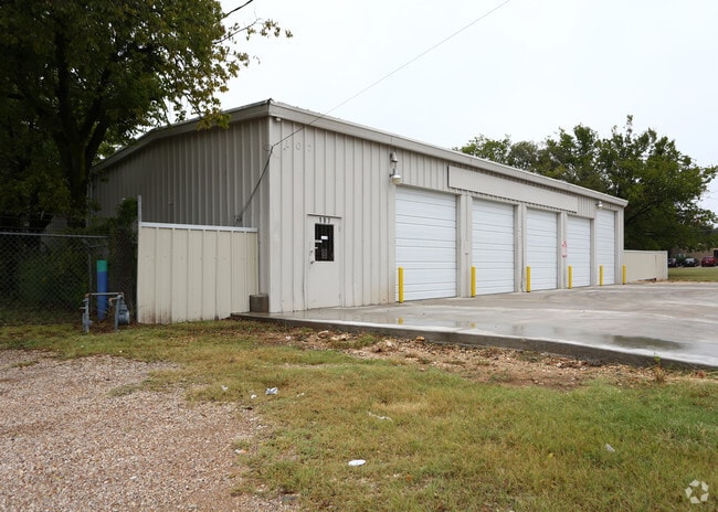
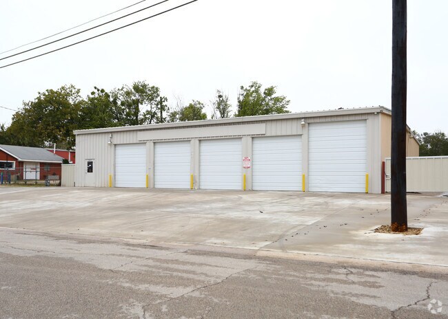
Property Record
107 Batterson St, Cleburne, TX 76031

Property Detail
107 Batterson St
126-0124-21100
ABST 124 TR 110 C CHANEY
Commercialnec
Johnson
B and X Area of moderate flood hazard, usually the area between the limits of the 100-year and 500-year floods.
Texas
2024
0.64 AC
2025
Johnson County
130800
Dallas/Ft Worth
3,744 SF
Dallas-Fort Worth-Arlington, TX
NEARBY LISTINGS FOR SALE OR LEASE
DEMOGRAPHICS near 107 Batterson St
1 mile
3 mile
5 mile
2025 Total Population
10,317
34,404
51,225
2030 Population
11,835
39,311
58,581
Pop Growth 2025-2030
+ 14.71%
+ 14.26%
+ 14.36%
Average Age
36
38
38
2025 Total Households
3,392
12,060
17,901
HH Growth 2025-2030
+ 14.42%
+ 13.93%
+ 14.06%
Median Household Inc
$61,898
$66,763
$68,413
Avg Household Size
2.80
2.70
2.70
2025 Avg HH Vehicles
2.00
2.00
2.00
Median Home Value
$165,046
$217,602
$245,612
Median Year Built
1979
1981
1985
Nearby Places
Map Layers
Map Styles
 Street
 Aerial
Transit
 Traffic
 Biking
Places
Listings with unknown addresses are not visible on the map
- Restaurants
- Banks
- Shops
- Fitness
- Groceries
PUBLIC TRANSPORTATION
COMMUTER RAIL
Drive
Walk
Distance
3 min
1.5 mi
SALE & LEASE HISTORY
LISTING DATE
SALE/LEASE

Oct 24, 2016
For Lease
Oct 24, 2016
For Sale
Aug 09, 2017
For Sale
Nearby Properties
Address
Land Use
TOTAL SIZE
Lot Size
Zoning
Address
Land Use
TOTAL SIZE
Lot Size
Zoning
Address
Land Use
TOTAL SIZE
Lot Size
Zoning
178,055 SF
408.63 AC
Address
Land Use
TOTAL SIZE
Lot Size
Zoning
1 SF
0.21 AC
Address
Land Use
TOTAL SIZE
Lot Size
Zoning
1.14 AC
Address
Land Use
TOTAL SIZE
Lot Size
Zoning
1.14 AC
Address
Land Use
TOTAL SIZE
Lot Size
Zoning
1.14 AC
Address
Land Use
TOTAL SIZE
Lot Size
Zoning
11,176 SF
0.08 AC
Address
Land Use
TOTAL SIZE
Lot Size
Zoning
81,253 SF
3.51 AC
Address
Land Use
TOTAL SIZE
Lot Size
Zoning
146,927 SF
33.55 AC
Address
Land Use
TOTAL SIZE
Lot Size
Zoning
11.04 AC
Address
Land Use
TOTAL SIZE
Lot Size
Zoning
26,932 SF
17.62 AC
Address
Land Use
TOTAL SIZE
Lot Size
Zoning
1.01 AC
Address
Land Use
TOTAL SIZE
Lot Size
Zoning
Address
Land Use
TOTAL SIZE
Lot Size
Zoning
271,345 SF
0.21 AC
Address
Land Use
TOTAL SIZE
Lot Size
Zoning
61,492 SF
20.24 AC
Address
Land Use
TOTAL SIZE
Lot Size
Zoning
69,592 SF
29.56 AC
Address
Land Use
TOTAL SIZE
Lot Size
Zoning
74,275 SF
23.13 AC
Address
Land Use
TOTAL SIZE
Lot Size
Zoning
67,699 SF
43.74 AC
Address
Land Use
TOTAL SIZE
Lot Size
Zoning
67,564 SF
11 AC
Address
Land Use
TOTAL SIZE
Lot Size
Zoning
66,480 SF
61.65 AC
Address
Land Use
TOTAL SIZE
Lot Size
Zoning
24.44 AC
Address
Land Use
TOTAL SIZE
Lot Size
Zoning
207,010 SF
25.39 AC
Address
Land Use
TOTAL SIZE
Lot Size
Zoning
612,261 SF
0.21 AC
Address
Land Use
TOTAL SIZE
Lot Size
Zoning
668,640 SF
0.08 AC
Address
Land Use
TOTAL SIZE
Lot Size
Zoning
394,274 SF
Address
Land Use
TOTAL SIZE
Lot Size
Zoning
1 SF
35.23 AC
Address
Land Use
TOTAL SIZE
Lot Size
Zoning
90.80 AC
Address
Land Use
TOTAL SIZE
Lot Size
Zoning
3,264 SF
6.63 AC
Address
Land Use
TOTAL SIZE
Lot Size
Zoning
12,000 SF
5.54 AC
Address
Land Use
TOTAL SIZE
Lot Size
Zoning
68,230 SF
8.15 AC
The World's #1 Commercial Real Estate Marketplace
Connect with us
© 2026 CoStar Group
The information above has been obtained from sources believed reliable. While we do not doubt its accuracy we have not verified it and make no guarantee, warranty or representation about it. It is your responsibility to independently confirm its accuracy and completeness. Any projections, opinions, assumptions, or estimates used are for example only and do not represent the current or future performance of the property. The value of this transaction to you depends on tax and other factors which should be evaluated by your tax, financial, and legal advisors. You and your advisors should conduct a careful, independent investigation of the property to determine to your satisfaction the suitability of the property for your needs.