Property Record
107 E Eureka Ave, Eureka, IL 61530
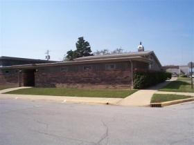


Property Detail
107 E Eureka Ave
Peoria, IL
T26N - R1W - S07 LOT 6, PT LOT 7 BLK 14 ORIGINAL TOWN OF EUREKA
14-07-306-010
WOODFORD
Officebuilding
Illinois
B and X Area of moderate flood hazard, usually the area between the limits of the 100-year and 500-year floods.
6-7
2025
0.25 AC
2025
Woodford County
030601
Peoria
NEARBY LISTINGS FOR SALE OR LEASE
-
-
View all Eureka listings for sale on LoopNet.com
DEMOGRAPHICS near 107 E Eureka Ave
1 mile
3 mile
5 mile
2025 Total Population
4,345
6,364
6,982
2030 Population
4,386
6,434
7,051
Pop Growth 2025-2030
+ 0.94%
+ 1.10%
+ 0.99%
Average Age
40
40
40
2025 Total Households
1,669
2,382
2,612
HH Growth 2025-2030
+ 0.96%
+ 1.13%
+ 1.00%
Median Household Inc
$51,075
$63,750
$66,128
Avg Household Size
2.30
2.40
2.40
2025 Avg HH Vehicles
2.00
2.00
2.00
Median Home Value
$154,966
$174,115
$177,849
Median Year Built
1958
1970
1971
Nearby Places
Map Layers
Map Styles
 Street
 Aerial
Layers
 Traffic
 Biking
Places
Listings with unknown addresses are not visible on the map
- Restaurants
- Banks
- Shops
- Fitness
- Groceries
PUBLIC TRANSPORTATION
AIRPORT
General Downing - Peoria International
Drive
Walk
Distance
General Downing - Peoria International
41 min
25.1 mi
Central Il Regional/Bloomington-Normal
Drive
Walk
Distance
Central Il Regional/Bloomington-Normal
49 min
32.7 mi
Freight Ports
Port Milwaukee
Drive
Walk
Distance
Port Milwaukee
241 min
212.0 mi
Nearby Properties
Address
Land Use
TOTAL SIZE
Lot Size
Zoning
Address
Land Use
TOTAL SIZE
Lot Size
Zoning
46,406 SF
13.04 AC
Address
Land Use
TOTAL SIZE
Lot Size
Zoning
161,472 SF
10.63 AC
Address
Land Use
TOTAL SIZE
Lot Size
Zoning
2.81 AC
Address
Land Use
TOTAL SIZE
Lot Size
Zoning
6.67 AC
Address
Land Use
TOTAL SIZE
Lot Size
Zoning
42,350 SF
0.69 AC
Address
Land Use
TOTAL SIZE
Lot Size
Zoning
18,000 SF
4.12 AC
Address
Land Use
TOTAL SIZE
Lot Size
Zoning
Address
Land Use
TOTAL SIZE
Lot Size
Zoning
Address
Land Use
TOTAL SIZE
Lot Size
Zoning
18,200 SF
1.38 AC
Address
Land Use
TOTAL SIZE
Lot Size
Zoning
12.16 AC
Address
Land Use
TOTAL SIZE
Lot Size
Zoning
Address
Land Use
TOTAL SIZE
Lot Size
Zoning
20,020 SF
15.97 AC
Address
Land Use
TOTAL SIZE
Lot Size
Zoning
5,102 SF
4.83 AC
Address
Land Use
TOTAL SIZE
Lot Size
Zoning
7,210 SF
0.77 AC
Address
Land Use
TOTAL SIZE
Lot Size
Zoning
4.51 AC
Address
Land Use
TOTAL SIZE
Lot Size
Zoning
17.32 AC
Address
Land Use
TOTAL SIZE
Lot Size
Zoning
0.50 AC
Address
Land Use
TOTAL SIZE
Lot Size
Zoning
1.23 AC
Address
Land Use
TOTAL SIZE
Lot Size
Zoning
2.50 AC
Address
Land Use
TOTAL SIZE
Lot Size
Zoning
4,180 SF
1.27 AC
Address
Land Use
TOTAL SIZE
Lot Size
Zoning
3,075 SF
55.90 AC
Address
Land Use
TOTAL SIZE
Lot Size
Zoning
3,350 SF
1 AC
Address
Land Use
TOTAL SIZE
Lot Size
Zoning
0.28 AC
Address
Land Use
TOTAL SIZE
Lot Size
Zoning
0.78 AC
Address
Land Use
TOTAL SIZE
Lot Size
Zoning
4,368 SF
24.30 AC
Address
Land Use
TOTAL SIZE
Lot Size
Zoning
0.47 AC
Address
Land Use
TOTAL SIZE
Lot Size
Zoning
4,674 SF
3.50 AC
The World's #1 Commercial Real Estate Marketplace
Connect with us
© 2026 CoStar Group
The information above has been obtained from sources believed reliable. While we do not doubt its accuracy we have not verified it and make no guarantee, warranty or representation about it. It is your responsibility to independently confirm its accuracy and completeness. Any projections, opinions, assumptions, or estimates used are for example only and do not represent the current or future performance of the property. The value of this transaction to you depends on tax and other factors which should be evaluated by your tax, financial, and legal advisors. You and your advisors should conduct a careful, independent investigation of the property to determine to your satisfaction the suitability of the property for your needs.