Property Record
107 Industrial Ct, Freeport, FL 32439
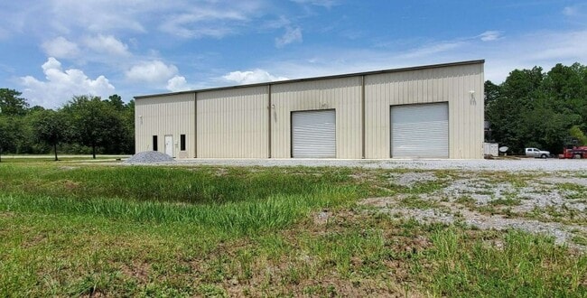


This Property Is For Sale
NEARBY LISTINGS FOR SALE OR LEASE
Property Detail
107 Industrial Ct
34-1N-19-17000-002-0041
COM AT THE INTSEC OF THE S LINE OF SEC 34 & THE E ROW OF ST RD 83 (US 331), INTSEC LYING ON A CURVE CONCAVE SELY & HAVING A RAD OF 5729.65 FT; THENCE NELY ALONG ELY ROW, THRU A CENTRAL ANGLE OF 12 DEG 2441, AN ARC DIST OF 1241.16 (CHORD B&D=N 20 DEG
Warehouse
Walton
X
Florida
12131C0420H
41
2025
0.78 AC
2025
Florida Panhandle Area
950501
Other Market Areas
6,914 SF
Crestview-Fort Walton Beach-Destin, FL
DEMOGRAPHICS near 107 Industrial Ct
1 Mile
3 Mile
5 Mile
2024 Total Population
424
2,321
8,204
2029 Population
533
2,910
10,094
Pop Growth 2024-2029
+ 25.71%
+ 25.38%
+ 23.04%
Average Age
35
36
39
2024 Total Households
157
863
3,013
HH Growth 2024-2029
+ 26.11%
+ 25.72%
+ 23.17%
Median Household Inc
$43,912
$44,101
$51,013
Avg Household Size
2.70
2.70
2.70
2024 Avg HH Vehicles
2.00
2.00
2.00
Median Home Value
$241,666
$252,539
$298,468
Median Year Built
2010
2010
2010
Nearby Places
Map Layers
Map Styles
 Street
 Aerial
- Restaurants
- Banks
- Shops
- Fitness
- Groceries
PUBLIC TRANSPORTATION
AIRPORT
Eglin AFB/Destin-Ft Walton Beach
DRIVE
WALK
Distance
Eglin AFB/Destin-Ft Walton Beach
64 min
31.4 mi
Northwest Florida Beaches International
DRIVE
WALK
Distance
Northwest Florida Beaches International
48 min
34.1 mi
Freight Ports
Port of Panama City
DRIVE
WALK
Distance
Port of Panama City
65 min
44.7 mi
Nearby Properties
Address
Land Use
TOTAL SIZE
Lot Size
Zoning
Address
Land Use
TOTAL SIZE
Lot Size
Zoning
158,757 SF
80 AC
3310
Address
Land Use
TOTAL SIZE
Lot Size
Zoning
161,667 SF
26.97 AC
3310
Address
Land Use
TOTAL SIZE
Lot Size
Zoning
188,494 SF
23.32 AC
3310
Address
Land Use
TOTAL SIZE
Lot Size
Zoning
83,348 SF
12.68 AC
MUNI
Address
Land Use
TOTAL SIZE
Lot Size
Zoning
150.04 AC
3310
Address
Land Use
TOTAL SIZE
Lot Size
Zoning
306.09 AC
3310
Address
Land Use
TOTAL SIZE
Lot Size
Zoning
87,549 SF
11 AC
Address
Land Use
TOTAL SIZE
Lot Size
Zoning
333.09 AC
3310
Address
Land Use
TOTAL SIZE
Lot Size
Zoning
1,759 SF
0.63 AC
Address
Land Use
TOTAL SIZE
Lot Size
Zoning
88.24 AC
3310
Address
Land Use
TOTAL SIZE
Lot Size
Zoning
2,304 SF
264.96 AC
3310
Address
Land Use
TOTAL SIZE
Lot Size
Zoning
31,217 SF
5.45 AC
3310
Address
Land Use
TOTAL SIZE
Lot Size
Zoning
151.52 AC
Address
Land Use
TOTAL SIZE
Lot Size
Zoning
Address
Land Use
TOTAL SIZE
Lot Size
Zoning
30,164 SF
2.23 AC
3310
Address
Land Use
TOTAL SIZE
Lot Size
Zoning
28,886 SF
20 AC
Address
Land Use
TOTAL SIZE
Lot Size
Zoning
17,730 SF
2.68 AC
Address
Land Use
TOTAL SIZE
Lot Size
Zoning
628 AC
3310
Address
Land Use
TOTAL SIZE
Lot Size
Zoning
25.96 AC
Address
Land Use
TOTAL SIZE
Lot Size
Zoning
154.72 AC
Address
Land Use
TOTAL SIZE
Lot Size
Zoning
53,078 SF
8.63 AC
3310
Address
Land Use
TOTAL SIZE
Lot Size
Zoning
9,044 SF
4.40 AC
Address
Land Use
TOTAL SIZE
Lot Size
Zoning
147.94 AC
3310
Address
Land Use
TOTAL SIZE
Lot Size
Zoning
146.12 AC
3310
Address
Land Use
TOTAL SIZE
Lot Size
Zoning
477 AC
3310
Address
Land Use
TOTAL SIZE
Lot Size
Zoning
15,076 SF
6 AC
Address
Land Use
TOTAL SIZE
Lot Size
Zoning
9,815 SF
1.65 AC
3310
Address
Land Use
TOTAL SIZE
Lot Size
Zoning
15,075 SF
6.13 AC
Address
Land Use
TOTAL SIZE
Lot Size
Zoning
18,420 SF
4.51 AC
The World's #1 Commercial Real Estate Marketplace
Connect with us
© 2025 CoStar Group
The information above has been obtained from sources believed reliable. While we do not doubt its accuracy we have not verified it and make no guarantee, warranty or representation about it. It is your responsibility to independently confirm its accuracy and completeness. Any projections, opinions, assumptions, or estimates used are for example only and do not represent the current or future performance of the property. The value of this transaction to you depends on tax and other factors which should be evaluated by your tax, financial, and legal advisors. You and your advisors should conduct a careful, independent investigation of the property to determine to your satisfaction the suitability of the property for your needs.