Property Record
107 Mcnutt Rd, Hutto, TX 78634
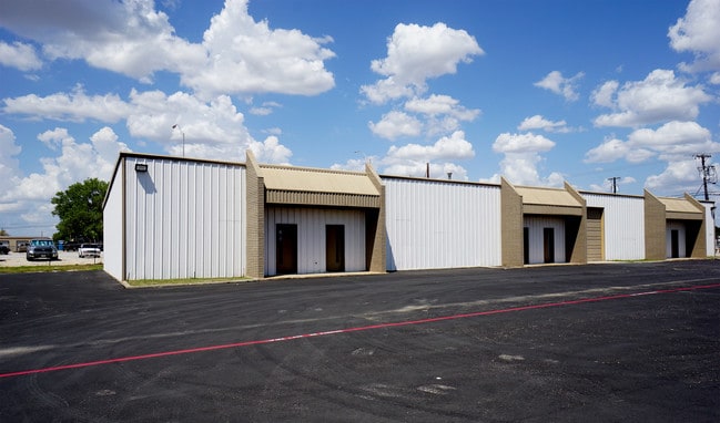


Property Detail
107 Mcnutt Rd
R086316
AW0422 MCNUTT, R. SUR., ACRES 2.64
Commercialnec
Williamson
B and X Area of moderate flood hazard, usually the area between the limits of the 100-year and 500-year floods.
Texas
2024
2.64 AC
2025
Georgetown
020817
Austin
16,310 SF
Austin-Round Rock-San Marcos, TX
NEARBY LISTINGS FOR SALE OR LEASE
-
-
-
-
-
-
SE Corner of Innovation Blvd. and Limmer loop
Hutto, TX 78634
Rent Upon Request
102,060 SF
Industrial
-
-
View all Hutto listings for lease on LoopNet.com
DEMOGRAPHICS near 107 Mcnutt Rd
1 mile
3 mile
5 mile
2024 Total Population
4,034
72,940
184,144
2029 Population
5,117
92,180
227,786
Pop Growth 2024-2029
+ 26.85%
+ 26.38%
+ 23.70%
Average Age
35
36
36
2024 Total Households
1,284
23,755
63,136
HH Growth 2024-2029
+ 27.49%
+ 26.99%
+ 24.34%
Median Household Inc
$126,095
$115,907
$101,011
Avg Household Size
3.10
3.00
2.90
2024 Avg HH Vehicles
2.00
2.00
2.00
Median Home Value
$382,526
$357,535
$344,450
Median Year Built
2011
2010
2007
Nearby Places
Map Layers
Map Styles
 Street
 Aerial
Transit
 Traffic
 Biking
Places
Listings with unknown addresses are not visible on the map
- Restaurants
- Banks
- Shops
- Fitness
- Groceries
PUBLIC TRANSPORTATION
AIRPORT
Austin-Bergstrom International
Drive
Walk
Distance
Austin-Bergstrom International
41 min
33.5 mi
Freight Ports
Calhoun Port
Drive
Walk
Distance
Calhoun Port
202 min
176.5 mi
SALE & LEASE HISTORY
LISTING DATE
SALE/LEASE

Aug 23, 2018
For Lease
Nearby Properties
Address
Land Use
TOTAL SIZE
Lot Size
Zoning
Address
Land Use
TOTAL SIZE
Lot Size
Zoning
1,240,638 SF
171.60 AC
Address
Land Use
TOTAL SIZE
Lot Size
Zoning
533,782 SF
79.41 AC
Address
Land Use
TOTAL SIZE
Lot Size
Zoning
425,891 SF
20.85 AC
Address
Land Use
TOTAL SIZE
Lot Size
Zoning
201,200 SF
9.48 AC
Address
Land Use
TOTAL SIZE
Lot Size
Zoning
409,416 SF
22.65 AC
Address
Land Use
TOTAL SIZE
Lot Size
Zoning
336,672 SF
15.09 AC
Address
Land Use
TOTAL SIZE
Lot Size
Zoning
302,465 SF
15.79 AC
Address
Land Use
TOTAL SIZE
Lot Size
Zoning
331,584 SF
21.09 AC
Address
Land Use
TOTAL SIZE
Lot Size
Zoning
315,884 SF
15.05 AC
Address
Land Use
TOTAL SIZE
Lot Size
Zoning
253,225 SF
12.25 AC
Address
Land Use
TOTAL SIZE
Lot Size
Zoning
301,721 SF
16.54 AC
Address
Land Use
TOTAL SIZE
Lot Size
Zoning
308,759 SF
13.93 AC
Address
Land Use
TOTAL SIZE
Lot Size
Zoning
290,840 SF
20.08 AC
Address
Land Use
TOTAL SIZE
Lot Size
Zoning
165,534 SF
26.91 AC
Address
Land Use
TOTAL SIZE
Lot Size
Zoning
76.14 AC
Address
Land Use
TOTAL SIZE
Lot Size
Zoning
230,841 SF
17.51 AC
Address
Land Use
TOTAL SIZE
Lot Size
Zoning
183,310 SF
10.78 AC
Address
Land Use
TOTAL SIZE
Lot Size
Zoning
123,325 SF
14.13 AC
SF2
Address
Land Use
TOTAL SIZE
Lot Size
Zoning
8,640 SF
30.11 AC
RREXP
Address
Land Use
TOTAL SIZE
Lot Size
Zoning
160,070 SF
13.68 AC
Address
Land Use
TOTAL SIZE
Lot Size
Zoning
195,520 SF
14.89 AC
Address
Land Use
TOTAL SIZE
Lot Size
Zoning
161,782 SF
12.32 AC
Address
Land Use
TOTAL SIZE
Lot Size
Zoning
154,528 SF
7.23 AC
Address
Land Use
TOTAL SIZE
Lot Size
Zoning
220,850 SF
12.06 AC
Address
Land Use
TOTAL SIZE
Lot Size
Zoning
107,588 SF
10.82 AC
Address
Land Use
TOTAL SIZE
Lot Size
Zoning
161,190 SF
8.82 AC
Address
Land Use
TOTAL SIZE
Lot Size
Zoning
215,475 SF
21.31 AC
PUD
Address
Land Use
TOTAL SIZE
Lot Size
Zoning
141,718 SF
24.12 AC
Address
Land Use
TOTAL SIZE
Lot Size
Zoning
535,408 SF
30.16 AC
Address
Land Use
TOTAL SIZE
Lot Size
Zoning
7,000 SF
94.53 AC
LI
The World's #1 Commercial Real Estate Marketplace
Connect with us
© 2026 CoStar Group
The information above has been obtained from sources believed reliable. While we do not doubt its accuracy we have not verified it and make no guarantee, warranty or representation about it. It is your responsibility to independently confirm its accuracy and completeness. Any projections, opinions, assumptions, or estimates used are for example only and do not represent the current or future performance of the property. The value of this transaction to you depends on tax and other factors which should be evaluated by your tax, financial, and legal advisors. You and your advisors should conduct a careful, independent investigation of the property to determine to your satisfaction the suitability of the property for your needs.