Property Record
107 N Ellsworth Rd, Mesa, AZ 85207


NEARBY LISTINGS FOR SALE OR LEASE
-
-
View all Mesa listings for sale on LoopNet.com
Property Detail
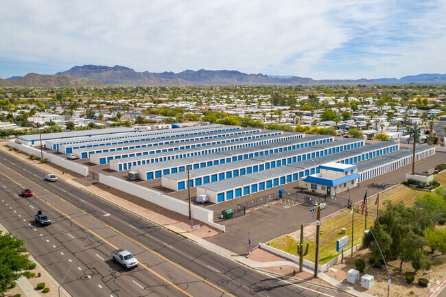
107 N Ellsworth Rd
220-27-001B
W2 NW4 SW4 NW4 SEC 22 EX W 55F & N 30F RDS & ALSO EX 35F X 35F TRI IN NW COR TH/OF & ALSO W2 E2 NW4 SW4 NW4 SEC 22 EX N 30F RD
Publicstorage
Maricopa
X
Arizona
04013C2295L
6.35 AC
2025
Mesa East
2025
Phoenix
420115
Phoenix-Mesa-Scottsdale, AZ
90,954 SF
DEMOGRAPHICS near 107 N Ellsworth Rd
1 Mile
3 Mile
5 Mile
2024 Total Population
15,173
99,870
230,634
2029 Population
16,512
109,001
255,752
Pop Growth 2024-2029
+ 8.82%
+ 9.14%
+ 10.89%
Average Age
41
44
45
2024 Total Households
6,100
40,198
94,472
HH Growth 2024-2029
+ 8.85%
+ 9.48%
+ 11.27%
Median Household Inc
$45,883
$63,561
$67,298
Avg Household Size
2.50
2.40
2.40
2024 Avg HH Vehicles
2.00
2.00
2.00
Median Home Value
$115,539
$279,409
$315,074
Median Year Built
1988
1994
1993
Nearby Places
Map Layers
Map Styles
 Street
 Aerial
- Restaurants
- Banks
- Shops
- Fitness
- Groceries
PUBLIC TRANSPORTATION
AIRPORT
Phoenix-Mesa Gateway
DRIVE
WALK
Distance
Phoenix-Mesa Gateway
19 min
11.7 mi
Phoenix Sky Harbor International
DRIVE
WALK
Distance
Phoenix Sky Harbor International
34 min
25.6 mi
Nearby Properties
Address
Land Use
TOTAL SIZE
Lot Size
Zoning
Address
Land Use
TOTAL SIZE
Lot Size
Zoning
493,357 SF
46.94 AC
C-N
Address
Land Use
TOTAL SIZE
Lot Size
Zoning
330,352 SF
28.30 AC
PF
Address
Land Use
TOTAL SIZE
Lot Size
Zoning
57.25 AC
PF
Address
Land Use
TOTAL SIZE
Lot Size
Zoning
324,534 SF
50.86 AC
PF
Address
Land Use
TOTAL SIZE
Lot Size
Zoning
390,917 SF
15.82 AC
RM4
Address
Land Use
TOTAL SIZE
Lot Size
Zoning
422,427 SF
18.21 AC
C-C
Address
Land Use
TOTAL SIZE
Lot Size
Zoning
4.77 AC
LC
Address
Land Use
TOTAL SIZE
Lot Size
Zoning
345,968 SF
14.65 AC
RM4
Address
Land Use
TOTAL SIZE
Lot Size
Zoning
13.52 AC
Address
Land Use
TOTAL SIZE
Lot Size
Zoning
10.63 AC
Address
Land Use
TOTAL SIZE
Lot Size
Zoning
244,351 SF
18.46 AC
RS43
Address
Land Use
TOTAL SIZE
Lot Size
Zoning
162,260 SF
7.62 AC
Address
Land Use
TOTAL SIZE
Lot Size
Zoning
172,756 SF
8.52 AC
LC
Address
Land Use
TOTAL SIZE
Lot Size
Zoning
1.68 AC
Address
Land Use
TOTAL SIZE
Lot Size
Zoning
1.68 AC
Address
Land Use
TOTAL SIZE
Lot Size
Zoning
82,772 SF
131.12 AC
PF
Address
Land Use
TOTAL SIZE
Lot Size
Zoning
267,380 SF
17.08 AC
M-H
Address
Land Use
TOTAL SIZE
Lot Size
Zoning
129,076 SF
17.32 AC
C-G
Address
Land Use
TOTAL SIZE
Lot Size
Zoning
190,630 SF
6.61 AC
M-H
Address
Land Use
TOTAL SIZE
Lot Size
Zoning
80,180 SF
6.44 AC
R-43
Address
Land Use
TOTAL SIZE
Lot Size
Zoning
210,413 SF
21.72 AC
C-G
Address
Land Use
TOTAL SIZE
Lot Size
Zoning
201,114 SF
11.66 AC
M-H
Address
Land Use
TOTAL SIZE
Lot Size
Zoning
142,817 SF
11.44 AC
RS43
Address
Land Use
TOTAL SIZE
Lot Size
Zoning
163,562 SF
16.34 AC
Address
Land Use
TOTAL SIZE
Lot Size
Zoning
124,850 SF
12.09 AC
RM4
Address
Land Use
TOTAL SIZE
Lot Size
Zoning
308,103 SF
14.78 AC
M-H
Address
Land Use
TOTAL SIZE
Lot Size
Zoning
138,077 SF
15.17 AC
C-G
Address
Land Use
TOTAL SIZE
Lot Size
Zoning
242,845 SF
49.50 AC
I-1
Address
Land Use
TOTAL SIZE
Lot Size
Zoning
87,423 SF
9.43 AC
C-G
Address
Land Use
TOTAL SIZE
Lot Size
Zoning
222,228 SF
6.66 AC
RM4
The World's #1 Commercial Real Estate Marketplace
Connect with us
© 2025 CoStar Group
The information above has been obtained from sources believed reliable. While we do not doubt its accuracy we have not verified it and make no guarantee, warranty or representation about it. It is your responsibility to independently confirm its accuracy and completeness. Any projections, opinions, assumptions, or estimates used are for example only and do not represent the current or future performance of the property. The value of this transaction to you depends on tax and other factors which should be evaluated by your tax, financial, and legal advisors. You and your advisors should conduct a careful, independent investigation of the property to determine to your satisfaction the suitability of the property for your needs.