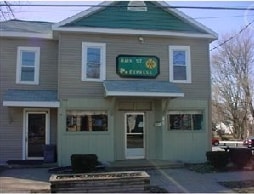
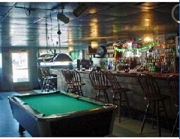
Property Record
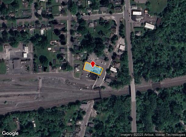
107 N Main St, Minoa, NY 13116

NEARBY LISTINGS FOR SALE OR LEASE
-
-
View all Minoa listings for sale on LoopNet.com
Property Detail
107 N Main St
313805-002-000-0003-009-000-0000
Onondaga
Commercialacreage
New York
X
9.000
36067C0234F
0.26 AC
2025
SE Outer Onondaga County
2024
Syracuse
015400
Syracuse, NY
DEMOGRAPHICS near 107 N Main St
1 Mile
3 Mile
5 Mile
2024 Total Population
3,880
12,840
49,538
2029 Population
3,819
12,554
48,411
Pop Growth 2024-2029
(1.57%)
(2.23%)
(2.28%)
Average Age
43
45
43
2024 Total Households
1,594
5,310
20,663
HH Growth 2024-2029
(1.63%)
(2.41%)
(2.41%)
Median Household Inc
$65,079
$84,312
$76,762
Avg Household Size
2.40
2.30
2.30
2024 Avg HH Vehicles
2.00
2.00
2.00
Median Home Value
$144,422
$176,404
$187,529
Median Year Built
1965
1968
1964
Nearby Places
- Restaurants
- Banks
- Shops
- Fitness
- Groceries
PUBLIC TRANSPORTATION
AIRPORT
Syracuse Hancock International
DRIVE
WALK
Distance
Syracuse Hancock International
23 min
14.2 mi
Freight Ports
Albany, NY Port
DRIVE
WALK
Distance
Albany, NY Port
172 min
142.6 mi
Nearby Properties
Address
Land Use
TOTAL SIZE
Lot Size
Zoning
Address
Land Use
TOTAL SIZE
Lot Size
Zoning
175,424 SF
7.85 AC
RA
Address
Land Use
TOTAL SIZE
Lot Size
Zoning
174,750 SF
10.40 AC
06 - INDUS
Address
Land Use
TOTAL SIZE
Lot Size
Zoning
104,400 SF
12.84 AC
06 - INDUS
Address
Land Use
TOTAL SIZE
Lot Size
Zoning
3,909 SF
24.98 AC
RA
Address
Land Use
TOTAL SIZE
Lot Size
Zoning
145,588 SF
75.45 AC
RA
Address
Land Use
TOTAL SIZE
Lot Size
Zoning
141,151 SF
20.23 AC
06 - INDUS
Address
Land Use
TOTAL SIZE
Lot Size
Zoning
115,150 SF
13.32 AC
RS
Address
Land Use
TOTAL SIZE
Lot Size
Zoning
95.24 AC
05 - COMME
Address
Land Use
TOTAL SIZE
Lot Size
Zoning
110,976 SF
42.31 AC
06 - INDUS
Address
Land Use
TOTAL SIZE
Lot Size
Zoning
150,216 SF
50.42 AC
RA
Address
Land Use
TOTAL SIZE
Lot Size
Zoning
21,882 SF
13.56 AC
05 - COMME
Address
Land Use
TOTAL SIZE
Lot Size
Zoning
78,950 SF
14.52 AC
NS
Address
Land Use
TOTAL SIZE
Lot Size
Zoning
69,910 SF
16.01 AC
06 - INDUS
Address
Land Use
TOTAL SIZE
Lot Size
Zoning
24.71 AC
RA
Address
Land Use
TOTAL SIZE
Lot Size
Zoning
169,505 SF
23.78 AC
06 - INDUS
Address
Land Use
TOTAL SIZE
Lot Size
Zoning
3,000 SF
75.84 AC
C
Address
Land Use
TOTAL SIZE
Lot Size
Zoning
37.08 AC
Address
Land Use
TOTAL SIZE
Lot Size
Zoning
1.86 AC
C
Address
Land Use
TOTAL SIZE
Lot Size
Zoning
68.78 AC
C
Address
Land Use
TOTAL SIZE
Lot Size
Zoning
15,040 SF
9.89 AC
IND
Address
Land Use
TOTAL SIZE
Lot Size
Zoning
37.36 AC
RA
Address
Land Use
TOTAL SIZE
Lot Size
Zoning
33.18 AC
C
Address
Land Use
TOTAL SIZE
Lot Size
Zoning
89,462 SF
9.22 AC
CB
Address
Land Use
TOTAL SIZE
Lot Size
Zoning
51,684 SF
17.68 AC
RA
Address
Land Use
TOTAL SIZE
Lot Size
Zoning
4,200 SF
25.34 AC
C
Address
Land Use
TOTAL SIZE
Lot Size
Zoning
77,962 SF
11 AC
06 - INDUS
Address
Land Use
TOTAL SIZE
Lot Size
Zoning
11,414 SF
1.13 AC
C
Address
Land Use
TOTAL SIZE
Lot Size
Zoning
23.21 AC
C
Address
Land Use
TOTAL SIZE
Lot Size
Zoning
109,440 SF
7.63 AC
06 - INDUS
Address
Land Use
TOTAL SIZE
Lot Size
Zoning
54,386 SF
9.45 AC
C
The World's #1 Commercial Real Estate Marketplace
Connect with us
© 2025 CoStar Group
The information above has been obtained from sources believed reliable. While we do not doubt its accuracy we have not verified it and make no guarantee, warranty or representation about it. It is your responsibility to independently confirm its accuracy and completeness. Any projections, opinions, assumptions, or estimates used are for example only and do not represent the current or future performance of the property. The value of this transaction to you depends on tax and other factors which should be evaluated by your tax, financial, and legal advisors. You and your advisors should conduct a careful, independent investigation of the property to determine to your satisfaction the suitability of the property for your needs.