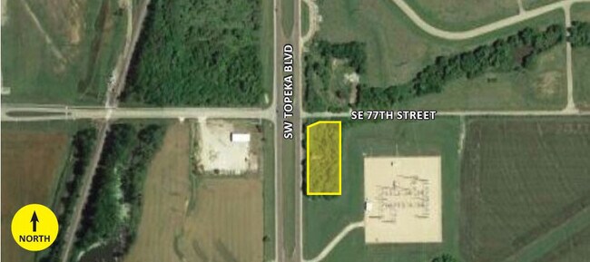
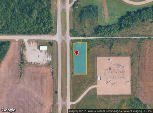
Property Record
107 Se 77Th St, Wakarusa, KS 66546
NEARBY LISTINGS FOR SALE OR LEASE
Property Detail
107 Se 77Th St
204-18-0-00-01-003-000
S18, T13, R16, ACRES 1.38, N 429 OF W 203.49 OF NW 1/4, LESS ROW
Commercialnec
Shawnee
X
Kansas
20177C0320E
1.38 AC
2024
Topeka
2025
Kansas City
003902
Topeka, KS
DEMOGRAPHICS near 107 Se 77Th St
1 Mile
3 Mile
5 Mile
2024 Total Population
364
4,028
14,227
2029 Population
361
3,996
14,068
Pop Growth 2024-2029
(0.82%)
(0.79%)
(1.12%)
Average Age
31
34
39
2024 Total Households
116
1,358
5,386
HH Growth 2024-2029
(0.86%)
(0.88%)
(1.06%)
Median Household Inc
$51,875
$60,110
$67,850
Avg Household Size
3.10
2.90
2.60
2024 Avg HH Vehicles
2.00
2.00
2.00
Median Home Value
$81,817
$151,657
$177,280
Median Year Built
1966
1968
1985
Nearby Places
Map Layers
Map Styles
 Street
 Aerial
- Restaurants
- Banks
- Shops
- Fitness
- Groceries
PUBLIC TRANSPORTATION
COMMUTER RAIL
Topeka Amtrak Station (Southwest Chief - Amtrak)
DRIVE
WALK
Distance
Topeka Amtrak Station (Southwest Chief - Amtrak)
16 min
9.6 mi
Freight Ports
Tulsa Port Of Catoosa
DRIVE
WALK
Distance
Tulsa Port Of Catoosa
263 min
216.2 mi
SALE & LEASE HISTORY
LISTING DATE
SALE/LEASE

Nov 09, 2021
For Sale
Nearby Properties
Address
Land Use
TOTAL SIZE
Lot Size
Zoning
Address
Land Use
TOTAL SIZE
Lot Size
Zoning
194.03 AC
I2
Address
Land Use
TOTAL SIZE
Lot Size
Zoning
42.18 AC
I2
Address
Land Use
TOTAL SIZE
Lot Size
Zoning
797,582 SF
384.32 AC
I1,I2
Address
Land Use
TOTAL SIZE
Lot Size
Zoning
577,341 SF
152.58 AC
I2
Address
Land Use
TOTAL SIZE
Lot Size
Zoning
1,351,980 SF
141.63 AC
I1
Address
Land Use
TOTAL SIZE
Lot Size
Zoning
602,448 SF
43.68 AC
I1
Address
Land Use
TOTAL SIZE
Lot Size
Zoning
1,250 SF
630.34 AC
RR1
Address
Land Use
TOTAL SIZE
Lot Size
Zoning
53,815 SF
15.40 AC
RR1
Address
Land Use
TOTAL SIZE
Lot Size
Zoning
188,358 SF
183.64 AC
I1,RR1
Address
Land Use
TOTAL SIZE
Lot Size
Zoning
64,248 SF
13.78 AC
RR1
Address
Land Use
TOTAL SIZE
Lot Size
Zoning
1,253,081 SF
73.17 AC
I1
Address
Land Use
TOTAL SIZE
Lot Size
Zoning
417.49 AC
RR1
Address
Land Use
TOTAL SIZE
Lot Size
Zoning
144.10 AC
PUD,I1,RR1
Address
Land Use
TOTAL SIZE
Lot Size
Zoning
34,744 SF
10.63 AC
I1,I2
Address
Land Use
TOTAL SIZE
Lot Size
Zoning
142.66 AC
RR1
Address
Land Use
TOTAL SIZE
Lot Size
Zoning
521,739 SF
25.22 AC
I1
Address
Land Use
TOTAL SIZE
Lot Size
Zoning
63,500 SF
1.93 AC
I1
Address
Land Use
TOTAL SIZE
Lot Size
Zoning
9.02 AC
Address
Land Use
TOTAL SIZE
Lot Size
Zoning
10,305 SF
63.93 AC
I1,RR1
Address
Land Use
TOTAL SIZE
Lot Size
Zoning
98,660 SF
13.73 AC
PUD,I1
Address
Land Use
TOTAL SIZE
Lot Size
Zoning
173.90 AC
RR1
Address
Land Use
TOTAL SIZE
Lot Size
Zoning
95,537 SF
5.68 AC
I2
Address
Land Use
TOTAL SIZE
Lot Size
Zoning
158.02 AC
RR1
Address
Land Use
TOTAL SIZE
Lot Size
Zoning
39,893 SF
1.77 AC
I1
Address
Land Use
TOTAL SIZE
Lot Size
Zoning
141,097 SF
12.01 AC
PUD,I1
Address
Land Use
TOTAL SIZE
Lot Size
Zoning
5.20 AC
PUD,I1
Address
Land Use
TOTAL SIZE
Lot Size
Zoning
98.45 AC
RR1
Address
Land Use
TOTAL SIZE
Lot Size
Zoning
15,072 SF
18.09 AC
I1,I2
Address
Land Use
TOTAL SIZE
Lot Size
Zoning
14,000 SF
75.65 AC
RR1
Address
Land Use
TOTAL SIZE
Lot Size
Zoning
49,068 SF
174.83 AC
I1,I2
The World's #1 Commercial Real Estate Marketplace
Connect with us
© 2025 CoStar Group
The information above has been obtained from sources believed reliable. While we do not doubt its accuracy we have not verified it and make no guarantee, warranty or representation about it. It is your responsibility to independently confirm its accuracy and completeness. Any projections, opinions, assumptions, or estimates used are for example only and do not represent the current or future performance of the property. The value of this transaction to you depends on tax and other factors which should be evaluated by your tax, financial, and legal advisors. You and your advisors should conduct a careful, independent investigation of the property to determine to your satisfaction the suitability of the property for your needs.