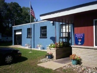
Property Record
107 W Allen Blvd, Kalamazoo, MI 49007

NEARBY LISTINGS FOR SALE OR LEASE
Property Detail
107 W Allen Blvd
Kalamazoo-Portage, MI
Allen Farm Plat
06-03-105-341
2042040 3906 03 105 341 ALLEN FARM PLAT LOT 34 EXC W 116.98 FT
Industrialgeneral
Kalamazoo
X
Michigan
26077C0179E
34
2024
0.87 AC
2025
NE Kalamazoo County
001501
West Michigan
4,950 SF
DEMOGRAPHICS near 107 W Allen Blvd
1 Mile
3 Mile
5 Mile
2024 Total Population
2,374
44,846
117,155
2029 Population
2,368
44,983
117,413
Pop Growth 2024-2029
(0.25%)
+ 0.31%
+ 0.22%
Average Age
39
36
36
2024 Total Households
957
18,429
48,459
HH Growth 2024-2029
(0.42%)
+ 0.36%
+ 0.27%
Median Household Inc
$52,666
$45,147
$48,299
Avg Household Size
2.40
2.30
2.20
2024 Avg HH Vehicles
2.00
2.00
2.00
Median Home Value
$161,508
$143,306
$163,118
Median Year Built
1956
1957
1967
Nearby Places
Map Layers
Map Styles
 Street
 Aerial
- Restaurants
- Banks
- Shops
- Fitness
- Groceries
PUBLIC TRANSPORTATION
COMMUTER RAIL
Kalamazoo (Blue Water - Amtrak, Wolverine - Amtrak)
DRIVE
WALK
Distance
Kalamazoo (Blue Water - Amtrak, Wolverine - Amtrak)
7 min
3.0 mi
AIRPORT
Kalamazoo/Battle Creek International
DRIVE
WALK
Distance
Kalamazoo/Battle Creek International
23 min
10.3 mi
Freight Ports
Port of Toledo
DRIVE
WALK
Distance
Port of Toledo
181 min
147.8 mi
Nearby Properties
Address
Land Use
TOTAL SIZE
Lot Size
Zoning
Address
Land Use
TOTAL SIZE
Lot Size
Zoning
632,218 SF
10.84 AC
M-1
Address
Land Use
TOTAL SIZE
Lot Size
Zoning
429,500 SF
2 AC
CCBD
Address
Land Use
TOTAL SIZE
Lot Size
Zoning
877,422 SF
38.18 AC
M-2
Address
Land Use
TOTAL SIZE
Lot Size
Zoning
110,686 SF
9.45 AC
CCBD
Address
Land Use
TOTAL SIZE
Lot Size
Zoning
390,900 SF
14 AC
I-M IND
Address
Land Use
TOTAL SIZE
Lot Size
Zoning
275,595 SF
0.65 AC
CCBD
Address
Land Use
TOTAL SIZE
Lot Size
Zoning
Address
Land Use
TOTAL SIZE
Lot Size
Zoning
50,826 SF
0.79 AC
CCBD
Address
Land Use
TOTAL SIZE
Lot Size
Zoning
12.58 AC
Address
Land Use
TOTAL SIZE
Lot Size
Zoning
274,412 SF
12.10 AC
RM-1
Address
Land Use
TOTAL SIZE
Lot Size
Zoning
99,092 SF
1.45 AC
CCBD
Address
Land Use
TOTAL SIZE
Lot Size
Zoning
171,772 SF
0.68 AC
CCBD
Address
Land Use
TOTAL SIZE
Lot Size
Zoning
185,528 SF
17.20 AC
R5
Address
Land Use
TOTAL SIZE
Lot Size
Zoning
232,072 SF
21.21 AC
PUD
Address
Land Use
TOTAL SIZE
Lot Size
Zoning
129,780 SF
0.78 AC
CCBD
Address
Land Use
TOTAL SIZE
Lot Size
Zoning
98,360 SF
13.58 AC
R4
Address
Land Use
TOTAL SIZE
Lot Size
Zoning
143,760 SF
10.25 AC
M-2
Address
Land Use
TOTAL SIZE
Lot Size
Zoning
118,104 SF
10.40 AC
R4
Address
Land Use
TOTAL SIZE
Lot Size
Zoning
9.65 AC
RM-36
Address
Land Use
TOTAL SIZE
Lot Size
Zoning
Address
Land Use
TOTAL SIZE
Lot Size
Zoning
86,855 SF
0.54 AC
CCBD
Address
Land Use
TOTAL SIZE
Lot Size
Zoning
49,216 SF
2.90 AC
RM-2
Address
Land Use
TOTAL SIZE
Lot Size
Zoning
275,595 SF
0.65 AC
CCBD
Address
Land Use
TOTAL SIZE
Lot Size
Zoning
1.72 AC
CMU
Address
Land Use
TOTAL SIZE
Lot Size
Zoning
8,214 SF
2.39 AC
C-3 GEN
Address
Land Use
TOTAL SIZE
Lot Size
Zoning
68,944 SF
0.74 AC
CCBD
Address
Land Use
TOTAL SIZE
Lot Size
Zoning
155,756 SF
0.67 AC
RM-2
Address
Land Use
TOTAL SIZE
Lot Size
Zoning
236,922 SF
13.32 AC
M-2
Address
Land Use
TOTAL SIZE
Lot Size
Zoning
35,248 SF
0.47 AC
CCBD
Address
Land Use
TOTAL SIZE
Lot Size
Zoning
345,312 SF
0.81 AC
CCBD
The World's #1 Commercial Real Estate Marketplace
Connect with us
© 2025 CoStar Group
The information above has been obtained from sources believed reliable. While we do not doubt its accuracy we have not verified it and make no guarantee, warranty or representation about it. It is your responsibility to independently confirm its accuracy and completeness. Any projections, opinions, assumptions, or estimates used are for example only and do not represent the current or future performance of the property. The value of this transaction to you depends on tax and other factors which should be evaluated by your tax, financial, and legal advisors. You and your advisors should conduct a careful, independent investigation of the property to determine to your satisfaction the suitability of the property for your needs.