Property Record
107 Walter Davis Dr, Birmingham, AL 35209


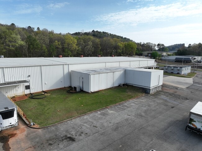
This Property Is For Sale
NEARBY LISTINGS FOR SALE OR LEASE
Property Detail
107 Walter Davis Dr
Birmingham-Hoover, AL
Durr Fil-R Mt Pk 29-15-1
29-00-15-1-001-005.000
LOTS 1 3 4 & 5 DURR-FILLAUER MEDICAL INC ADD TO RED MTN PARK 118/41 ALSO TRACT DESC AS FOLS:BEG INTER E/L OF ROBERT JEMISON RD & ALA POWER R/W IN NE 1/4 SEC 15 TP 18 R 3 TH NE 710 FT TH SE 410 FT TH SW 710 FT TH NW 290 FT TO POB
Warehouse
Jefferson
X
Alabama
01073C0552G
1
0
10 AC
2024
Vulcan/Oxmoor
005104
Birmingham
64,283 SF
DEMOGRAPHICS near 107 Walter Davis Dr
1 Mile
3 Mile
5 Mile
2024 Total Population
7,676
81,222
185,791
2029 Population
7,701
81,279
184,896
Pop Growth 2024-2029
+ 0.33%
+ 0.07%
(0.48%)
Average Age
38
37
39
2024 Total Households
4,138
35,222
80,488
HH Growth 2024-2029
+ 0.48%
+ 0.16%
(0.43%)
Median Household Inc
$35,272
$40,758
$46,642
Avg Household Size
1.80
2.10
2.10
2024 Avg HH Vehicles
2.00
2.00
2.00
Median Home Value
$165,310
$178,933
$227,571
Median Year Built
1978
1969
1967
Nearby Places
Map Layers
Map Styles
 Street
 Aerial
- Restaurants
- Banks
- Shops
- Fitness
- Groceries
PUBLIC TRANSPORTATION
COMMUTER RAIL
DRIVE
WALK
Distance
11 min
4.7 mi
AIRPORT
Birmingham-Shuttlesworth International
DRIVE
WALK
Distance
Birmingham-Shuttlesworth International
19 min
9.8 mi
Nearby Properties
Address
Land Use
TOTAL SIZE
Lot Size
Zoning
Address
Land Use
TOTAL SIZE
Lot Size
Zoning
978,879 SF
43.50 AC
I3
Address
Land Use
TOTAL SIZE
Lot Size
Zoning
239,334 SF
4.42 AC
B6
Address
Land Use
TOTAL SIZE
Lot Size
Zoning
203,878 SF
12.58 AC
B6
Address
Land Use
TOTAL SIZE
Lot Size
Zoning
31,980 SF
99.92 AC
I3/P
Address
Land Use
TOTAL SIZE
Lot Size
Zoning
242,746 SF
20.96 AC
MXDE
Address
Land Use
TOTAL SIZE
Lot Size
Zoning
334,805 SF
32.50 AC
MXD/
Address
Land Use
TOTAL SIZE
Lot Size
Zoning
200,927 SF
19 AC
PMUD
Address
Land Use
TOTAL SIZE
Lot Size
Zoning
344,150 SF
42 AC
R5
Address
Land Use
TOTAL SIZE
Lot Size
Zoning
209,765 SF
19.20 AC
I-3
Address
Land Use
TOTAL SIZE
Lot Size
Zoning
186,070 SF
16.60 AC
QB2
Address
Land Use
TOTAL SIZE
Lot Size
Zoning
416,477 SF
80 AC
R5
Address
Land Use
TOTAL SIZE
Lot Size
Zoning
109,819 SF
2.91 AC
M2
Address
Land Use
TOTAL SIZE
Lot Size
Zoning
156,986 SF
1.29 AC
M1
Address
Land Use
TOTAL SIZE
Lot Size
Zoning
311,982 SF
30 AC
R6
Address
Land Use
TOTAL SIZE
Lot Size
Zoning
97,377 SF
1.63 AC
M1
Address
Land Use
TOTAL SIZE
Lot Size
Zoning
33,209 SF
3.11 AC
C4B
Address
Land Use
TOTAL SIZE
Lot Size
Zoning
282,421 SF
24.33 AC
R7
Address
Land Use
TOTAL SIZE
Lot Size
Zoning
92,332 SF
8.40 AC
Address
Land Use
TOTAL SIZE
Lot Size
Zoning
65,685 SF
9.50 AC
B2
Address
Land Use
TOTAL SIZE
Lot Size
Zoning
265,418 SF
26.55 AC
R2
Address
Land Use
TOTAL SIZE
Lot Size
Zoning
133,396 SF
19 AC
QR6
Address
Land Use
TOTAL SIZE
Lot Size
Zoning
38,963 SF
0.24 AC
C4B
Address
Land Use
TOTAL SIZE
Lot Size
Zoning
403,758 SF
22.36 AC
R3
Address
Land Use
TOTAL SIZE
Lot Size
Zoning
55,797 SF
2.73 AC
M-1
Address
Land Use
TOTAL SIZE
Lot Size
Zoning
159,822 SF
1.30 AC
M1
Address
Land Use
TOTAL SIZE
Lot Size
Zoning
23,490 SF
1.45 AC
M1
Address
Land Use
TOTAL SIZE
Lot Size
Zoning
14,048 SF
18.90 AC
B6
Address
Land Use
TOTAL SIZE
Lot Size
Zoning
66,829 SF
3.44 AC
R-5
Address
Land Use
TOTAL SIZE
Lot Size
Zoning
97,875 SF
4.60 AC
R5
The World's #1 Commercial Real Estate Marketplace
Connect with us
© 2025 CoStar Group
The information above has been obtained from sources believed reliable. While we do not doubt its accuracy we have not verified it and make no guarantee, warranty or representation about it. It is your responsibility to independently confirm its accuracy and completeness. Any projections, opinions, assumptions, or estimates used are for example only and do not represent the current or future performance of the property. The value of this transaction to you depends on tax and other factors which should be evaluated by your tax, financial, and legal advisors. You and your advisors should conduct a careful, independent investigation of the property to determine to your satisfaction the suitability of the property for your needs.