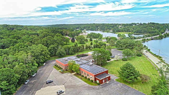
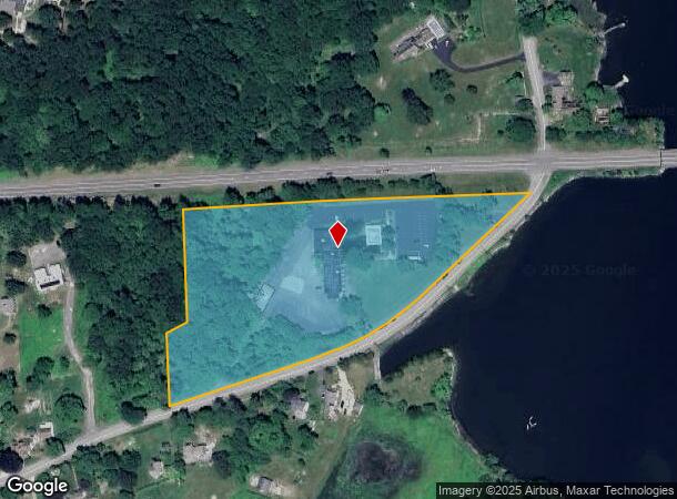
Property Record
107 Wilcox Rd, Stonington, CT 06378
Current Lease Availabilities
NEARBY LISTINGS FOR SALE OR LEASE
Property Detail
107 Wilcox Rd
STON-000156-000003-000001
New London
Multipleuses
Connecticut
AE
1
09011C0529J
6.95 AC
2024
SE New London
2025
Hartford
705300
Norwich-New London, CT
16,520 SF
DEMOGRAPHICS near 107 Wilcox Rd
1 Mile
3 Mile
5 Mile
2024 Total Population
1,367
13,633
26,815
2029 Population
1,402
13,838
27,179
Pop Growth 2024-2029
+ 2.56%
+ 1.50%
+ 1.36%
Average Age
52
51
48
2024 Total Households
647
6,188
11,818
HH Growth 2024-2029
+ 2.47%
+ 1.33%
+ 1.35%
Median Household Inc
$114,925
$114,673
$105,166
Avg Household Size
2.10
2.00
2.20
2024 Avg HH Vehicles
2.00
2.00
2.00
Median Home Value
$587,389
$466,193
$412,872
Median Year Built
1959
1959
1967
Nearby Places
- Restaurants
- Banks
- Shops
- Fitness
- Groceries
PUBLIC TRANSPORTATION
COMMUTER RAIL
DRIVE
WALK
Distance
3 min
1.7 mi
DRIVE
WALK
Distance
12 min
7.0 mi
AIRPORT
Rhode Island Tf Green International
DRIVE
WALK
Distance
Rhode Island Tf Green International
61 min
43.6 mi
Nearby Properties
Address
Land Use
TOTAL SIZE
Lot Size
Zoning
Address
Land Use
TOTAL SIZE
Lot Size
Zoning
18.02 AC
RM-15
Address
Land Use
TOTAL SIZE
Lot Size
Zoning
32.59 AC
RA-40
Address
Land Use
TOTAL SIZE
Lot Size
Zoning
18.17 AC
TC-80
Address
Land Use
TOTAL SIZE
Lot Size
Zoning
138,366 SF
11.20 AC
GDD
Address
Land Use
TOTAL SIZE
Lot Size
Zoning
139,952 SF
5.81 AC
GDD
Address
Land Use
TOTAL SIZE
Lot Size
Zoning
74,328 SF
19.50 AC
RR-80
Address
Land Use
TOTAL SIZE
Lot Size
Zoning
45,795 SF
5.60 AC
GDD
Address
Land Use
TOTAL SIZE
Lot Size
Zoning
120,243 SF
9.06 AC
TC-80
Address
Land Use
TOTAL SIZE
Lot Size
Zoning
40.80 AC
M-1
Address
Land Use
TOTAL SIZE
Lot Size
Zoning
7.35 AC
TC-80
Address
Land Use
TOTAL SIZE
Lot Size
Zoning
85,073 SF
17.60 AC
RA-20
Address
Land Use
TOTAL SIZE
Lot Size
Zoning
7.40 AC
M-1
Address
Land Use
TOTAL SIZE
Lot Size
Zoning
59,024 SF
3.24 AC
RS-12
Address
Land Use
TOTAL SIZE
Lot Size
Zoning
68,206 SF
6.40 AC
M-1
Address
Land Use
TOTAL SIZE
Lot Size
Zoning
19,274 SF
1.36 AC
GB-130
Address
Land Use
TOTAL SIZE
Lot Size
Zoning
55,089 SF
2.63 AC
GC-60
Address
Land Use
TOTAL SIZE
Lot Size
Zoning
25.88 AC
RR-80
Address
Land Use
TOTAL SIZE
Lot Size
Zoning
14.50 AC
GC-60
Address
Land Use
TOTAL SIZE
Lot Size
Zoning
46,652 SF
12.23 AC
RC-120
Address
Land Use
TOTAL SIZE
Lot Size
Zoning
0.77 AC
DB-5
Address
Land Use
TOTAL SIZE
Lot Size
Zoning
74,984 SF
15.63 AC
M-1
Address
Land Use
TOTAL SIZE
Lot Size
Zoning
35,520 SF
1.61 AC
MDD
Address
Land Use
TOTAL SIZE
Lot Size
Zoning
39,667 SF
8.41 AC
RS-20
Address
Land Use
TOTAL SIZE
Lot Size
Zoning
48.70 AC
GB-130
Address
Land Use
TOTAL SIZE
Lot Size
Zoning
7,500 SF
2.87 AC
MC-80
Address
Land Use
TOTAL SIZE
Lot Size
Zoning
4.88 AC
TC-80
Address
Land Use
TOTAL SIZE
Lot Size
Zoning
51,929 SF
77.39 AC
RU-80
Address
Land Use
TOTAL SIZE
Lot Size
Zoning
4.22 AC
TC-80
Address
Land Use
TOTAL SIZE
Lot Size
Zoning
11,858 SF
GB-130
Address
Land Use
TOTAL SIZE
Lot Size
Zoning
3.50 AC
RC-120
The World's #1 Commercial Real Estate Marketplace
Connect with us
© 2025 CoStar Group
The information above has been obtained from sources believed reliable. While we do not doubt its accuracy we have not verified it and make no guarantee, warranty or representation about it. It is your responsibility to independently confirm its accuracy and completeness. Any projections, opinions, assumptions, or estimates used are for example only and do not represent the current or future performance of the property. The value of this transaction to you depends on tax and other factors which should be evaluated by your tax, financial, and legal advisors. You and your advisors should conduct a careful, independent investigation of the property to determine to your satisfaction the suitability of the property for your needs.