No Photo
Property Record
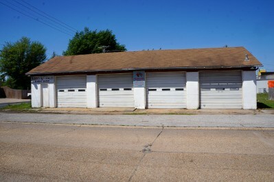
107 Williams St, Kennett, MO 63857

Property Detail
107 Williams St
Kennett, MO
KELLEY: S 81' LOT 1 BLK 2
15-01.0-01-002-02-001.000.000
Dunklin
Commercialnec
Missouri
2024
1
2025
0.11 AC
360600
Missouri South Area
1,800 SF
Other Market Areas
NEARBY LISTINGS FOR SALE OR LEASE
-
-
View all Kennett listings for sale on LoopNet.com
DEMOGRAPHICS near 107 Williams St
1 mile
3 mile
5 mile
2025 Total Population
4,129
10,362
11,041
2030 Population
3,992
10,049
10,702
Pop Growth 2025-2030
(3.32%)
(3.02%)
(3.07%)
Average Age
38
40
40
2025 Total Households
1,737
4,149
4,422
HH Growth 2025-2030
(3.51%)
(3.13%)
(3.19%)
Median Household Inc
$41,383
$55,422
$54,766
Avg Household Size
2.20
2.30
2.30
2025 Avg HH Vehicles
1.00
2.00
2.00
Median Home Value
$87,054
$122,016
$121,728
Median Year Built
1973
1969
1970
Nearby Places
Map Layers
Map Styles
 Street
 Aerial
Transit
 Traffic
 Biking
Places
Listings with unknown addresses are not visible on the map
- Restaurants
- Banks
- Shops
- Fitness
- Groceries
SALE & LEASE HISTORY
LISTING DATE
SALE/LEASE

Jul 27, 2017
For Sale
Nearby Properties
Address
Land Use
TOTAL SIZE
Lot Size
Zoning
Address
Land Use
TOTAL SIZE
Lot Size
Zoning
1,460 SF
55.62 AC
Address
Land Use
TOTAL SIZE
Lot Size
Zoning
148,631 SF
19.63 AC
Address
Land Use
TOTAL SIZE
Lot Size
Zoning
10,159 SF
23 AC
Address
Land Use
TOTAL SIZE
Lot Size
Zoning
50,000 SF
19.99 AC
Address
Land Use
TOTAL SIZE
Lot Size
Zoning
87,911 SF
Address
Land Use
TOTAL SIZE
Lot Size
Zoning
1,412 SF
25.80 AC
Address
Land Use
TOTAL SIZE
Lot Size
Zoning
16,571 SF
4.49 AC
Address
Land Use
TOTAL SIZE
Lot Size
Zoning
6,426 SF
8.92 AC
Address
Land Use
TOTAL SIZE
Lot Size
Zoning
19,893 SF
2.30 AC
Address
Land Use
TOTAL SIZE
Lot Size
Zoning
16,298 SF
3.70 AC
Address
Land Use
TOTAL SIZE
Lot Size
Zoning
50,405 SF
100.74 AC
Address
Land Use
TOTAL SIZE
Lot Size
Zoning
20,357 SF
7.94 AC
Address
Land Use
TOTAL SIZE
Lot Size
Zoning
25,328 SF
1.80 AC
Address
Land Use
TOTAL SIZE
Lot Size
Zoning
6,131 SF
23.50 AC
Address
Land Use
TOTAL SIZE
Lot Size
Zoning
16,567 SF
1.60 AC
Address
Land Use
TOTAL SIZE
Lot Size
Zoning
8,620 SF
2.61 AC
Address
Land Use
TOTAL SIZE
Lot Size
Zoning
31,047 SF
2.40 AC
Address
Land Use
TOTAL SIZE
Lot Size
Zoning
7,534 SF
1.20 AC
Address
Land Use
TOTAL SIZE
Lot Size
Zoning
5,924 SF
2.30 AC
Address
Land Use
TOTAL SIZE
Lot Size
Zoning
5,616 SF
Address
Land Use
TOTAL SIZE
Lot Size
Zoning
7,553 SF
0.32 AC
Address
Land Use
TOTAL SIZE
Lot Size
Zoning
2,450 SF
9.70 AC
Address
Land Use
TOTAL SIZE
Lot Size
Zoning
2,004 SF
7.73 AC
Address
Land Use
TOTAL SIZE
Lot Size
Zoning
7,971 SF
0.53 AC
Address
Land Use
TOTAL SIZE
Lot Size
Zoning
20,863 SF
0.98 AC
Address
Land Use
TOTAL SIZE
Lot Size
Zoning
1,200 SF
7.10 AC
Address
Land Use
TOTAL SIZE
Lot Size
Zoning
15,000 SF
6.50 AC
Address
Land Use
TOTAL SIZE
Lot Size
Zoning
5,400 SF
2.12 AC
Address
Land Use
TOTAL SIZE
Lot Size
Zoning
12,899 SF
2 AC
Address
Land Use
TOTAL SIZE
Lot Size
Zoning
The World's #1 Commercial Real Estate Marketplace
Connect with us
© 2026 CoStar Group
The information above has been obtained from sources believed reliable. While we do not doubt its accuracy we have not verified it and make no guarantee, warranty or representation about it. It is your responsibility to independently confirm its accuracy and completeness. Any projections, opinions, assumptions, or estimates used are for example only and do not represent the current or future performance of the property. The value of this transaction to you depends on tax and other factors which should be evaluated by your tax, financial, and legal advisors. You and your advisors should conduct a careful, independent investigation of the property to determine to your satisfaction the suitability of the property for your needs.