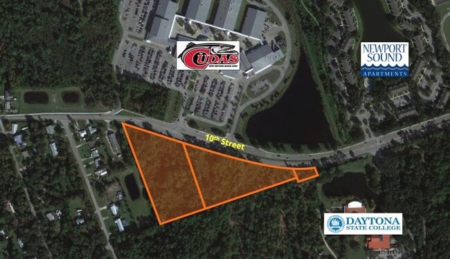
Property Record
1070 10Th St, New Smyrna Beach, FL 32168
This Property Is For Sale
NEARBY LISTINGS FOR SALE OR LEASE
Property Detail
1070 10Th St
Deltona-Daytona Beach-Ormond Beach, FL
Extention Model Land Co Add
7419-23-00-0490
48-17-34 LOTS 50 & 51 S OF 10TH ST EXTENTION MODEL LAND CO ADD NEW SMYRNA MB 4 PG 9 MB 16 PG 71 EXC PARCEL MEAS 760.52 FT ON W/L & 336.47 FT ON S/L PER OR 1874 PG 1245 PER OR 2835 PG 1751 PER OR 3086 PG 0056 PER OR 8277 PG 2487
Residentialacreage
Volusia
X
Florida
12127C0543J
50,51
2025
4.47 AC
2025
South Beach Cities
082903
Deltona/Daytona Beach
DEMOGRAPHICS near 1070 10Th St
1 Mile
3 Mile
5 Mile
2024 Total Population
2,495
31,214
64,279
2029 Population
2,768
34,969
72,764
Pop Growth 2024-2029
+ 10.94%
+ 12.03%
+ 13.20%
Average Age
44
49
50
2024 Total Households
1,016
14,327
29,742
HH Growth 2024-2029
+ 11.12%
+ 12.35%
+ 13.64%
Median Household Inc
$47,083
$55,329
$59,997
Avg Household Size
2.20
2.00
2.10
2024 Avg HH Vehicles
2.00
2.00
2.00
Median Home Value
$283,333
$262,181
$274,281
Median Year Built
1984
1983
1985
Nearby Places
- Restaurants
- Banks
- Shops
- Fitness
- Groceries
PUBLIC TRANSPORTATION
AIRPORT
Daytona Beach International
DRIVE
WALK
Distance
Daytona Beach International
29 min
19.0 mi
Orlando Sanford International
DRIVE
WALK
Distance
Orlando Sanford International
49 min
32.8 mi
Freight Ports
Port Canaveral
DRIVE
WALK
Distance
Port Canaveral
72 min
57.2 mi
Nearby Properties
Address
Land Use
TOTAL SIZE
Lot Size
Zoning
Address
Land Use
TOTAL SIZE
Lot Size
Zoning
317,281 SF
21.97 AC
RR
Address
Land Use
TOTAL SIZE
Lot Size
Zoning
360,394 SF
65.63 AC
01R4
Address
Land Use
TOTAL SIZE
Lot Size
Zoning
177,619 SF
6.91 AC
10R2
Address
Land Use
TOTAL SIZE
Lot Size
Zoning
260,126 SF
2 AC
10R3
Address
Land Use
TOTAL SIZE
Lot Size
Zoning
108,577 SF
20 AC
10R2
Address
Land Use
TOTAL SIZE
Lot Size
Zoning
209,027 SF
29.13 AC
10R2A
Address
Land Use
TOTAL SIZE
Lot Size
Zoning
150,044 SF
19.80 AC
R4
Address
Land Use
TOTAL SIZE
Lot Size
Zoning
134,246 SF
13.58 AC
10B5
Address
Land Use
TOTAL SIZE
Lot Size
Zoning
23,142 SF
7.98 AC
R
Address
Land Use
TOTAL SIZE
Lot Size
Zoning
91,509 SF
4.06 AC
I1
Address
Land Use
TOTAL SIZE
Lot Size
Zoning
7,345 SF
0.43 AC
MH1
Address
Land Use
TOTAL SIZE
Lot Size
Zoning
91,759 SF
10.15 AC
10B2
Address
Land Use
TOTAL SIZE
Lot Size
Zoning
5,249 SF
0.42 AC
01MH5
Address
Land Use
TOTAL SIZE
Lot Size
Zoning
94,251 SF
18.51 AC
Address
Land Use
TOTAL SIZE
Lot Size
Zoning
87,154 SF
1.08 AC
10R5
Address
Land Use
TOTAL SIZE
Lot Size
Zoning
110,926 SF
7.02 AC
Address
Land Use
TOTAL SIZE
Lot Size
Zoning
51,507 SF
10.61 AC
B3C
Address
Land Use
TOTAL SIZE
Lot Size
Zoning
43,852 SF
8.81 AC
RR
Address
Land Use
TOTAL SIZE
Lot Size
Zoning
111,686 SF
10.03 AC
10B5
Address
Land Use
TOTAL SIZE
Lot Size
Zoning
47,434 SF
11.41 AC
10R3
Address
Land Use
TOTAL SIZE
Lot Size
Zoning
74,609 SF
12.67 AC
10B3
Address
Land Use
TOTAL SIZE
Lot Size
Zoning
119,537 SF
12.06 AC
PUD
Address
Land Use
TOTAL SIZE
Lot Size
Zoning
55,587 SF
85.39 AC
R4
Address
Land Use
TOTAL SIZE
Lot Size
Zoning
229,941 SF
0.57 AC
10R2A
Address
Land Use
TOTAL SIZE
Lot Size
Zoning
115,028 SF
16.51 AC
R4
Address
Land Use
TOTAL SIZE
Lot Size
Zoning
44,239 SF
2.31 AC
10B1
Address
Land Use
TOTAL SIZE
Lot Size
Zoning
2,628 SF
3.04 AC
Address
Land Use
TOTAL SIZE
Lot Size
Zoning
98,105 SF
8.03 AC
07B3
Address
Land Use
TOTAL SIZE
Lot Size
Zoning
108,762 SF
11.60 AC
RA
Address
Land Use
TOTAL SIZE
Lot Size
Zoning
70,088 SF
0.30 AC
10R5
The World's #1 Commercial Real Estate Marketplace
Connect with us
© 2025 CoStar Group
The information above has been obtained from sources believed reliable. While we do not doubt its accuracy we have not verified it and make no guarantee, warranty or representation about it. It is your responsibility to independently confirm its accuracy and completeness. Any projections, opinions, assumptions, or estimates used are for example only and do not represent the current or future performance of the property. The value of this transaction to you depends on tax and other factors which should be evaluated by your tax, financial, and legal advisors. You and your advisors should conduct a careful, independent investigation of the property to determine to your satisfaction the suitability of the property for your needs.