Property Record
1070 Cider Mill Loop, Weaverville, NC 28787


Save to a Folder
{{folder.Name}}
{{folder.ListingIds.length}} Properties
{{folder.ListingIds.length}} Property
Create a New Folder
Property Detail
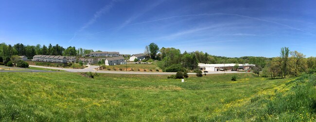
1070 Cider Mill Loop
9742-03-2555-00000
PLAT: 0241-0025
Apartment
BUNCOMBE
I-1
North Carolina
AE The base floodplain where base flood elevations are provided. AE Zones are now used on new format FIRMs instead of A1-A30 Zones.
10.50 AC
0
Buncombe County
2025
Asheville
002701
Asheville, NC
52,470 SF
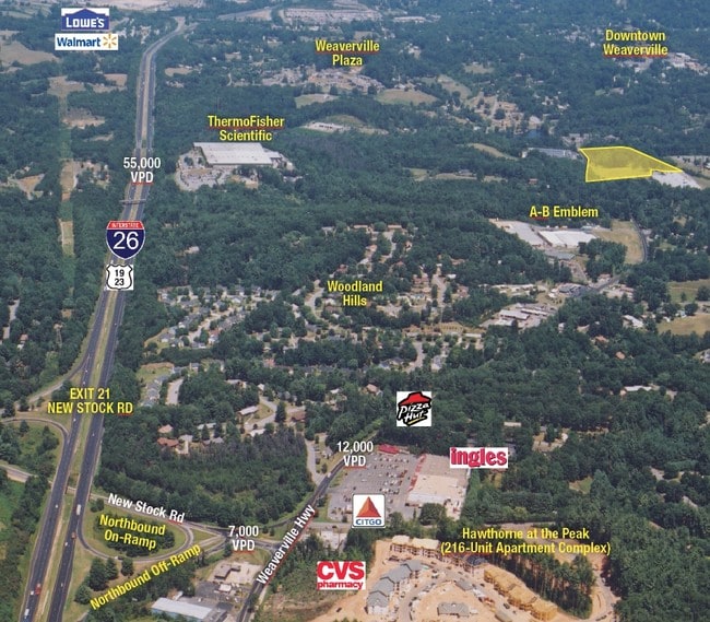
NEARBY LISTINGS FOR SALE OR LEASE
DEMOGRAPHICS near 1070 Cider Mill Loop
1 mile
3 mile
5 mile
2025 Total Population
3,440
20,411
45,844
2030 Population
3,572
21,282
47,512
Pop Growth 2025-2030
+ 3.84%
+ 4.27%
+ 3.64%
Average Age
47
47
45
2025 Total Households
1,566
8,769
19,384
HH Growth 2025-2030
+ 3.58%
+ 4.09%
+ 3.40%
Median Household Inc
$85,698
$85,238
$85,809
Avg Household Size
2.10
2.20
2.20
2025 Avg HH Vehicles
2.00
2.00
2.00
Median Home Value
$477,965
$512,180
$493,163
Median Year Built
1988
1995
1987
Nearby Places
Map Layers
Map Styles
 Street
 Aerial
Layers
 Traffic
 Biking
Places
Listings with unknown addresses are not visible on the map
- Restaurants
- Banks
- Shops
- Fitness
- Groceries
PUBLIC TRANSPORTATION
AIRPORT
Asheville Regional
Drive
Walk
Distance
Asheville Regional
29 min
21.4 mi
Freight Ports
North Charleston Terminal
Drive
Walk
Distance
North Charleston Terminal
300 min
265.1 mi
SALE & LEASE HISTORY
LISTING DATE
SALE/LEASE

Sep 24, 2016
For Sale
May 17, 2018
For Sale
May 15, 2017
For Sale
Nearby Properties
Address
Land Use
TOTAL SIZE
Lot Size
Zoning
Address
Land Use
TOTAL SIZE
Lot Size
Zoning
101,676 SF
19.40 AC
EMP
Address
Land Use
TOTAL SIZE
Lot Size
Zoning
70,312 SF
16.85 AC
I-1
Address
Land Use
TOTAL SIZE
Lot Size
Zoning
75,122 SF
16.91 AC
SHOPPING
Address
Land Use
TOTAL SIZE
Lot Size
Zoning
108,948 SF
24.68 AC
R-3
Address
Land Use
TOTAL SIZE
Lot Size
Zoning
64,521 SF
14.16 AC
R-3
Address
Land Use
TOTAL SIZE
Lot Size
Zoning
68,691 SF
131.92 AC
HEAVY
Address
Land Use
TOTAL SIZE
Lot Size
Zoning
134,304 SF
16.10 AC
C-2
Address
Land Use
TOTAL SIZE
Lot Size
Zoning
61,043 SF
6.89 AC
SHOPPING
Address
Land Use
TOTAL SIZE
Lot Size
Zoning
93,500 SF
60.64 AC
OU
Address
Land Use
TOTAL SIZE
Lot Size
Zoning
51,555 SF
8.34 AC
R-1
Address
Land Use
TOTAL SIZE
Lot Size
Zoning
187,648 SF
18.85 AC
I-1
Address
Land Use
TOTAL SIZE
Lot Size
Zoning
414,493 SF
34.02 AC
I-1
Address
Land Use
TOTAL SIZE
Lot Size
Zoning
139,265 SF
14.97 AC
I-1
Address
Land Use
TOTAL SIZE
Lot Size
Zoning
98,003 SF
11.96 AC
C-2
Address
Land Use
TOTAL SIZE
Lot Size
Zoning
28,247 SF
3.22 AC
C-2
Address
Land Use
TOTAL SIZE
Lot Size
Zoning
47,374 SF
6.84 AC
C-2
Address
Land Use
TOTAL SIZE
Lot Size
Zoning
166,387 SF
23.84 AC
I-1
Address
Land Use
TOTAL SIZE
Lot Size
Zoning
14,380 SF
2.14 AC
SHOPPING
Address
Land Use
TOTAL SIZE
Lot Size
Zoning
91,988 SF
28.95 AC
R-3
Address
Land Use
TOTAL SIZE
Lot Size
Zoning
35,776 SF
13.26 AC
R-1
Address
Land Use
TOTAL SIZE
Lot Size
Zoning
7.54 AC
R-1
Address
Land Use
TOTAL SIZE
Lot Size
Zoning
38,346 SF
4.96 AC
R-1
Address
Land Use
TOTAL SIZE
Lot Size
Zoning
27,832 SF
7.96 AC
SHOPPING
Address
Land Use
TOTAL SIZE
Lot Size
Zoning
20,816 SF
3.48 AC
R-1
Address
Land Use
TOTAL SIZE
Lot Size
Zoning
35,844 SF
1.58 AC
SHOPPING
Address
Land Use
TOTAL SIZE
Lot Size
Zoning
33,369 SF
10.02 AC
R-10
Address
Land Use
TOTAL SIZE
Lot Size
Zoning
37,419 SF
4.15 AC
C-2
Address
Land Use
TOTAL SIZE
Lot Size
Zoning
265,885 SF
33.47 AC
I-1
Address
Land Use
TOTAL SIZE
Lot Size
Zoning
53,760 SF
4.04 AC
R-3
The World's #1 Commercial Real Estate Marketplace
Connect with us
© 2026 CoStar Group
The information above has been obtained from sources believed reliable. While we do not doubt its accuracy we have not verified it and make no guarantee, warranty or representation about it. It is your responsibility to independently confirm its accuracy and completeness. Any projections, opinions, assumptions, or estimates used are for example only and do not represent the current or future performance of the property. The value of this transaction to you depends on tax and other factors which should be evaluated by your tax, financial, and legal advisors. You and your advisors should conduct a careful, independent investigation of the property to determine to your satisfaction the suitability of the property for your needs.