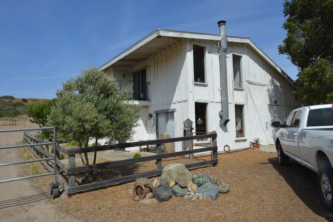
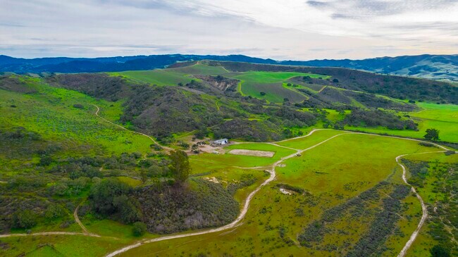
Property Record
1070 Drum Canyon Rd, Lompoc, CA 93436

Property Detail
1070 Drum Canyon Rd
Santa Maria-Santa Barbara, CA
POR OF L 28 29 2 3 AND 4 SEC 32 TWN 7 RNG 32
099-180-011
SANTA BARBARA
Agriculturalland
California
AGII100
28
B and X Area of moderate flood hazard, usually the area between the limits of the 100-year and 500-year floods.
296.92 AC
2024
Central SB County
2025
Santa Barbara/Sta Maria/Goleta
001911
NEARBY LISTINGS FOR SALE OR LEASE
DEMOGRAPHICS near 1070 Drum Canyon Rd
1 mile
3 mile
5 mile
2025 Total Population
10
173
1,341
2030 Population
9
156
1,267
Pop Growth 2025-2030
(10.00%)
(9.83%)
(5.52%)
Average Age
42
44
43
2025 Total Households
4
65
502
HH Growth 2025-2030
(25.00%)
(10.77%)
(5.58%)
Median Household Inc
$199,999
$154,167
$105,514
Avg Household Size
2.00
2.70
2.70
2025 Avg HH Vehicles
3.00
3.00
2.00
Median Home Value
$999,999
$1,066,667
$824,585
Median Year Built
1977
1980
1989
Nearby Places
Map Layers
Map Styles
 Street
 Aerial
Layers
 Traffic
 Biking
Places
Listings with unknown addresses are not visible on the map
- Restaurants
- Banks
- Shops
- Fitness
- Groceries
PUBLIC TRANSPORTATION
AIRPORT
Santa Barbara Municipal
Drive
Walk
Distance
Santa Barbara Municipal
71 min
43.9 mi
Freight Ports
The Port of Hueneme
Drive
Walk
Distance
The Port of Hueneme
119 min
90.5 mi
SALE & LEASE HISTORY
LISTING DATE
SALE/LEASE

Jul 14, 2022
For Sale
Aug 13, 2024
For Sale
Nearby Properties
Address
Land Use
TOTAL SIZE
Lot Size
Zoning
Address
Land Use
TOTAL SIZE
Lot Size
Zoning
448.33 AC
AGII100
Address
Land Use
TOTAL SIZE
Lot Size
Zoning
1,002.93 AC
AGII100
Address
Land Use
TOTAL SIZE
Lot Size
Zoning
2,330 SF
152.34 AC
AGII100
Address
Land Use
TOTAL SIZE
Lot Size
Zoning
1,124 SF
348.52 AC
AGII100
Address
Land Use
TOTAL SIZE
Lot Size
Zoning
1,725 SF
305.70 AC
AGII100
Address
Land Use
TOTAL SIZE
Lot Size
Zoning
157.22 AC
AGII100
Address
Land Use
TOTAL SIZE
Lot Size
Zoning
81.50 AC
AGII100
Address
Land Use
TOTAL SIZE
Lot Size
Zoning
136.35 AC
AGII100
Address
Land Use
TOTAL SIZE
Lot Size
Zoning
39.23 AC
AGII100
Address
Land Use
TOTAL SIZE
Lot Size
Zoning
2,289 SF
246.96 AC
AGII100
Address
Land Use
TOTAL SIZE
Lot Size
Zoning
1,877 SF
98.70 AC
AGII100
Address
Land Use
TOTAL SIZE
Lot Size
Zoning
203.52 AC
AGII100
Address
Land Use
TOTAL SIZE
Lot Size
Zoning
2,440 SF
44.52 AC
AGII100
Address
Land Use
TOTAL SIZE
Lot Size
Zoning
249.62 AC
Address
Land Use
TOTAL SIZE
Lot Size
Zoning
70.30 AC
AGII100
Address
Land Use
TOTAL SIZE
Lot Size
Zoning
203.61 AC
Address
Land Use
TOTAL SIZE
Lot Size
Zoning
3,032 SF
126.27 AC
AGII100
Address
Land Use
TOTAL SIZE
Lot Size
Zoning
2,040 SF
88.46 AC
AGII100
Address
Land Use
TOTAL SIZE
Lot Size
Zoning
1,600 SF
182.85 AC
AGII100
Address
Land Use
TOTAL SIZE
Lot Size
Zoning
42.50 AC
AGII100
Address
Land Use
TOTAL SIZE
Lot Size
Zoning
3,333 SF
44.53 AC
AGII100
Address
Land Use
TOTAL SIZE
Lot Size
Zoning
2,700 SF
10.63 AC
100AG
Address
Land Use
TOTAL SIZE
Lot Size
Zoning
503.49 AC
AGII100
Address
Land Use
TOTAL SIZE
Lot Size
Zoning
1,815 SF
462.93 AC
AGII100
Address
Land Use
TOTAL SIZE
Lot Size
Zoning
3,562 SF
4.69 AC
AGI20
Address
Land Use
TOTAL SIZE
Lot Size
Zoning
1,764 SF
10.01 AC
100AG
The World's #1 Commercial Real Estate Marketplace
Connect with us
© 2026 CoStar Group
The information above has been obtained from sources believed reliable. While we do not doubt its accuracy we have not verified it and make no guarantee, warranty or representation about it. It is your responsibility to independently confirm its accuracy and completeness. Any projections, opinions, assumptions, or estimates used are for example only and do not represent the current or future performance of the property. The value of this transaction to you depends on tax and other factors which should be evaluated by your tax, financial, and legal advisors. You and your advisors should conduct a careful, independent investigation of the property to determine to your satisfaction the suitability of the property for your needs.