Property Record
1070 E Glenbrook Dr, Pulaski, WI 54162
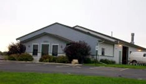

Property Detail
1070 E Glenbrook Dr
Green Bay, WI
64,014 SQ FT LOT 2 OF 35 CSM 169 MAP 5382 IN 1545508 BNG PRT OF LOT 6 PULASKI INDUSTRIAL PARK
VP-1290-L-7
Brown
Commercialnec
Wisconsin
B and X Area of moderate flood hazard, usually the area between the limits of the 100-year and 500-year floods.
2,6
2025
1.47 AC
2025
Howard
021600
Green Bay
NEARBY LISTINGS FOR SALE OR LEASE
-
-
View all Pulaski listings for sale on LoopNet.com
DEMOGRAPHICS near 1070 E Glenbrook Dr
1 mile
3 mile
5 mile
2025 Total Population
2,535
5,961
9,838
2030 Population
2,611
6,073
9,923
Pop Growth 2025-2030
+ 3.00%
+ 1.88%
+ 0.86%
Average Age
39
39
40
2025 Total Households
1,039
2,318
3,697
HH Growth 2025-2030
+ 3.08%
+ 1.90%
+ 0.87%
Median Household Inc
$67,880
$73,044
$84,063
Avg Household Size
2.40
2.60
2.70
2025 Avg HH Vehicles
2.00
2.00
2.00
Median Home Value
$274,242
$274,999
$296,360
Median Year Built
1982
1983
1986
Nearby Places
Map Layers
Map Styles
 Street
 Aerial
Layers
 Traffic
 Biking
Places
Listings with unknown addresses are not visible on the map
- Restaurants
- Banks
- Shops
- Fitness
- Groceries
PUBLIC TRANSPORTATION
AIRPORT
Green Bay/Austin Straubel International
Drive
Walk
Distance
Green Bay/Austin Straubel International
29 min
19.4 mi
Freight Ports
Port Milwaukee
Drive
Walk
Distance
Port Milwaukee
157 min
134.4 mi
Nearby Properties
Address
Land Use
TOTAL SIZE
Lot Size
Zoning
Address
Land Use
TOTAL SIZE
Lot Size
Zoning
10.37 AC
Address
Land Use
TOTAL SIZE
Lot Size
Zoning
4.42 AC
Address
Land Use
TOTAL SIZE
Lot Size
Zoning
Address
Land Use
TOTAL SIZE
Lot Size
Zoning
34.31 AC
Address
Land Use
TOTAL SIZE
Lot Size
Zoning
Address
Land Use
TOTAL SIZE
Lot Size
Zoning
8.37 AC
Address
Land Use
TOTAL SIZE
Lot Size
Zoning
6.23 AC
Address
Land Use
TOTAL SIZE
Lot Size
Zoning
2.88 AC
Address
Land Use
TOTAL SIZE
Lot Size
Zoning
Address
Land Use
TOTAL SIZE
Lot Size
Zoning
Address
Land Use
TOTAL SIZE
Lot Size
Zoning
Address
Land Use
TOTAL SIZE
Lot Size
Zoning
5.41 AC
Address
Land Use
TOTAL SIZE
Lot Size
Zoning
2.29 AC
Address
Land Use
TOTAL SIZE
Lot Size
Zoning
2.62 AC
Address
Land Use
TOTAL SIZE
Lot Size
Zoning
3.87 AC
Address
Land Use
TOTAL SIZE
Lot Size
Zoning
Address
Land Use
TOTAL SIZE
Lot Size
Zoning
3.30 AC
Address
Land Use
TOTAL SIZE
Lot Size
Zoning
2.46 AC
Address
Land Use
TOTAL SIZE
Lot Size
Zoning
4.90 AC
Address
Land Use
TOTAL SIZE
Lot Size
Zoning
3.15 AC
Address
Land Use
TOTAL SIZE
Lot Size
Zoning
1.51 AC
Address
Land Use
TOTAL SIZE
Lot Size
Zoning
2.78 AC
Address
Land Use
TOTAL SIZE
Lot Size
Zoning
4.75 AC
Address
Land Use
TOTAL SIZE
Lot Size
Zoning
9.54 AC
Address
Land Use
TOTAL SIZE
Lot Size
Zoning
5.38 AC
Address
Land Use
TOTAL SIZE
Lot Size
Zoning
5.43 AC
Address
Land Use
TOTAL SIZE
Lot Size
Zoning
16.52 AC
Address
Land Use
TOTAL SIZE
Lot Size
Zoning
1.50 AC
Address
Land Use
TOTAL SIZE
Lot Size
Zoning
3.59 AC
Address
Land Use
TOTAL SIZE
Lot Size
Zoning
19.65 AC
The World's #1 Commercial Real Estate Marketplace
Connect with us
© 2026 CoStar Group
The information above has been obtained from sources believed reliable. While we do not doubt its accuracy we have not verified it and make no guarantee, warranty or representation about it. It is your responsibility to independently confirm its accuracy and completeness. Any projections, opinions, assumptions, or estimates used are for example only and do not represent the current or future performance of the property. The value of this transaction to you depends on tax and other factors which should be evaluated by your tax, financial, and legal advisors. You and your advisors should conduct a careful, independent investigation of the property to determine to your satisfaction the suitability of the property for your needs.