Property Record
1070 Franklin Springs St, Royston, GA 30662
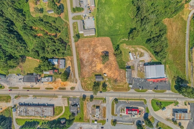
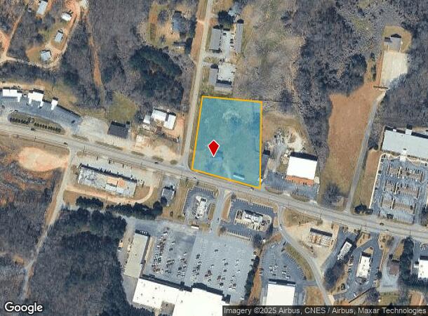
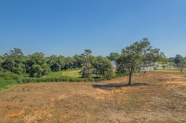
This Property Is For Sale
NEARBY LISTINGS FOR SALE OR LEASE
Property Detail
1070 Franklin Springs St
068A-029
Franklin
Sfr
Georgia
X
2.50 AC
13195C0050C
Georgia Northeast
1,278 SF
Other Market Areas
DEMOGRAPHICS near 1070 Franklin Springs St
1 Mile
3 Mile
5 Mile
2024 Total Population
2,178
5,448
9,231
2029 Population
2,332
5,820
9,900
Pop Growth 2024-2029
+ 7.07%
+ 6.83%
+ 7.25%
Average Age
37
39
40
2024 Total Households
753
2,017
3,460
HH Growth 2024-2029
+ 6.91%
+ 6.59%
+ 7.08%
Median Household Inc
$29,872
$41,439
$46,175
Avg Household Size
2.40
2.40
2.40
2024 Avg HH Vehicles
2.00
2.00
2.00
Median Home Value
$155,821
$160,133
$150,606
Median Year Built
1973
1977
1979
Nearby Places
Map Layers
Map Styles
 Street
 Aerial
- Restaurants
- Banks
- Shops
- Fitness
- Groceries
Nearby Properties
Address
Land Use
TOTAL SIZE
Lot Size
Zoning
Address
Land Use
TOTAL SIZE
Lot Size
Zoning
2,556 SF
93.69 AC
UNZONED RU
Address
Land Use
TOTAL SIZE
Lot Size
Zoning
228,564 SF
62.59 AC
Address
Land Use
TOTAL SIZE
Lot Size
Zoning
279,084 SF
68.28 AC
Address
Land Use
TOTAL SIZE
Lot Size
Zoning
15,000 SF
8.86 AC
COMMERCIAL
Address
Land Use
TOTAL SIZE
Lot Size
Zoning
2,035 SF
25.75 AC
UNZONED RU
Address
Land Use
TOTAL SIZE
Lot Size
Zoning
7,524 SF
3.89 AC
RESIDENTIA
Address
Land Use
TOTAL SIZE
Lot Size
Zoning
1,216 SF
66.97 AC
C
Address
Land Use
TOTAL SIZE
Lot Size
Zoning
2,248 SF
25 AC
Address
Land Use
TOTAL SIZE
Lot Size
Zoning
16,050 SF
2.49 AC
COMMERCIAL
Address
Land Use
TOTAL SIZE
Lot Size
Zoning
20,220 SF
5.15 AC
Address
Land Use
TOTAL SIZE
Lot Size
Zoning
18,693 SF
10.89 AC
COMMERCIAL
Address
Land Use
TOTAL SIZE
Lot Size
Zoning
37,555 SF
5.89 AC
COMMERCIAL
Address
Land Use
TOTAL SIZE
Lot Size
Zoning
19,156 SF
6.34 AC
COMMERCIAL
Address
Land Use
TOTAL SIZE
Lot Size
Zoning
8.88 AC
UNZONED SU
Address
Land Use
TOTAL SIZE
Lot Size
Zoning
37,561 SF
1.90 AC
COMMERCIAL
Address
Land Use
TOTAL SIZE
Lot Size
Zoning
4,381 SF
0.67 AC
RESIDENTIA
Address
Land Use
TOTAL SIZE
Lot Size
Zoning
186.46 AC
UNZONED RU
Address
Land Use
TOTAL SIZE
Lot Size
Zoning
33,337 SF
8.47 AC
RURAL
Address
Land Use
TOTAL SIZE
Lot Size
Zoning
172.60 AC
UNZONED RU
Address
Land Use
TOTAL SIZE
Lot Size
Zoning
720 SF
243.09 AC
C
Address
Land Use
TOTAL SIZE
Lot Size
Zoning
13,156 SF
2.17 AC
UNZONED RU
Address
Land Use
TOTAL SIZE
Lot Size
Zoning
164.09 AC
UNZONED RU
Address
Land Use
TOTAL SIZE
Lot Size
Zoning
768 SF
2.44 AC
COMMERCIAL
Address
Land Use
TOTAL SIZE
Lot Size
Zoning
5,050 SF
3.72 AC
COMMERCIAL
Address
Land Use
TOTAL SIZE
Lot Size
Zoning
29,878 SF
1.61 AC
COMMERCIAL
Address
Land Use
TOTAL SIZE
Lot Size
Zoning
4,226 SF
3 AC
UNZONED RU
Address
Land Use
TOTAL SIZE
Lot Size
Zoning
6,020 SF
2.39 AC
COMMERCIAL
Address
Land Use
TOTAL SIZE
Lot Size
Zoning
60,701 SF
6.50 AC
COMMERCIAL
Address
Land Use
TOTAL SIZE
Lot Size
Zoning
11,340 SF
2.61 AC
COMMERCIAL
Address
Land Use
TOTAL SIZE
Lot Size
Zoning
11,251 SF
1.72 AC
COMMERCIAL
The World's #1 Commercial Real Estate Marketplace
Connect with us
© 2025 CoStar Group
The information above has been obtained from sources believed reliable. While we do not doubt its accuracy we have not verified it and make no guarantee, warranty or representation about it. It is your responsibility to independently confirm its accuracy and completeness. Any projections, opinions, assumptions, or estimates used are for example only and do not represent the current or future performance of the property. The value of this transaction to you depends on tax and other factors which should be evaluated by your tax, financial, and legal advisors. You and your advisors should conduct a careful, independent investigation of the property to determine to your satisfaction the suitability of the property for your needs.