Property Record
1070 Freeland Dr, Salisbury, NC 28144

Property Detail
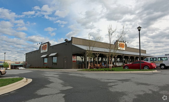
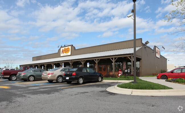
1070 Freeland Dr
059-A074
2.70AC L1
Restaurantbuilding
Rowan
B and X Area of moderate flood hazard, usually the area between the limits of the 100-year and 500-year floods.
North Carolina
2025
2.70 AC
2025
Rowan County
050202
Charlotte
10,266 SF
Charlotte-Concord-Gastonia, NC-SC
NEARBY LISTINGS FOR SALE OR LEASE
DEMOGRAPHICS near 1070 Freeland Dr
1 mile
3 mile
5 mile
2025 Total Population
6,530
33,497
57,365
2030 Population
6,830
35,016
59,832
Pop Growth 2025-2030
+ 4.59%
+ 4.53%
+ 4.30%
Average Age
40
40
41
2025 Total Households
2,663
13,357
22,819
HH Growth 2025-2030
+ 4.92%
+ 4.85%
+ 4.51%
Median Household Inc
$45,382
$56,296
$57,662
Avg Household Size
2.20
2.30
2.30
2025 Avg HH Vehicles
1.00
2.00
2.00
Median Home Value
$204,179
$244,587
$260,137
Median Year Built
1969
1972
1977
Nearby Places
Map Layers
Map Styles
 Street
 Aerial
Transit
 Traffic
 Biking
Places
Listings with unknown addresses are not visible on the map
- Restaurants
- Banks
- Shops
- Fitness
- Groceries
PUBLIC TRANSPORTATION
TRANSIT/SUBWAY
Salisbury Station (Piedmont - North Carolina by Train (NC Train))
Drive
Walk
Distance
Salisbury Station (Piedmont - North Carolina by Train (NC Train))
4 min
19 min
1.0 mi
COMMUTER RAIL
Salisbury Station (Piedmont - North Carolina by Train (NC Train))
Drive
Walk
Distance
Salisbury Station (Piedmont - North Carolina by Train (NC Train))
4 min
19 min
1.0 mi
AIRPORT
Concord-Padgett Regional
Drive
Walk
Distance
Concord-Padgett Regional
36 min
27.9 mi
Charlotte/Douglas International
Drive
Walk
Distance
Charlotte/Douglas International
63 min
48.2 mi
Nearby Properties
Address
Land Use
TOTAL SIZE
Lot Size
Zoning
Address
Land Use
TOTAL SIZE
Lot Size
Zoning
221,875 SF
7.31 AC
Address
Land Use
TOTAL SIZE
Lot Size
Zoning
193,040 SF
73.85 AC
Address
Land Use
TOTAL SIZE
Lot Size
Zoning
116,333 SF
30.31 AC
Address
Land Use
TOTAL SIZE
Lot Size
Zoning
61,191 SF
33.96 AC
Address
Land Use
TOTAL SIZE
Lot Size
Zoning
41,142 SF
16.18 AC
Address
Land Use
TOTAL SIZE
Lot Size
Zoning
48,865 SF
55.30 AC
HB:HIGHWAY
Address
Land Use
TOTAL SIZE
Lot Size
Zoning
668,345 SF
52.05 AC
Address
Land Use
TOTAL SIZE
Lot Size
Zoning
27,321 SF
11.66 AC
Address
Land Use
TOTAL SIZE
Lot Size
Zoning
99,416 SF
31.69 AC
Address
Land Use
TOTAL SIZE
Lot Size
Zoning
338,336 SF
32.55 AC
Address
Land Use
TOTAL SIZE
Lot Size
Zoning
144,720 SF
14.53 AC
Address
Land Use
TOTAL SIZE
Lot Size
Zoning
420,494 SF
52.79 AC
Address
Land Use
TOTAL SIZE
Lot Size
Zoning
420,494 SF
52.79 AC
Address
Land Use
TOTAL SIZE
Lot Size
Zoning
27,932 SF
108.40 AC
Address
Land Use
TOTAL SIZE
Lot Size
Zoning
59,528 SF
25.35 AC
Address
Land Use
TOTAL SIZE
Lot Size
Zoning
206,758 SF
24.40 AC
Address
Land Use
TOTAL SIZE
Lot Size
Zoning
37,281 SF
10 AC
Address
Land Use
TOTAL SIZE
Lot Size
Zoning
12,960 SF
22.04 AC
Address
Land Use
TOTAL SIZE
Lot Size
Zoning
82,856 SF
40.24 AC
Address
Land Use
TOTAL SIZE
Lot Size
Zoning
56,676 SF
2.73 AC
HB:HIGHWAY
Address
Land Use
TOTAL SIZE
Lot Size
Zoning
86,517 SF
14 AC
Address
Land Use
TOTAL SIZE
Lot Size
Zoning
25,068 SF
7.18 AC
HB:HIGHWAY
Address
Land Use
TOTAL SIZE
Lot Size
Zoning
59,092 SF
1.73 AC
Address
Land Use
TOTAL SIZE
Lot Size
Zoning
31,327 SF
1.86 AC
Address
Land Use
TOTAL SIZE
Lot Size
Zoning
69,072 SF
11.32 AC
HB:HIGHWAY
Address
Land Use
TOTAL SIZE
Lot Size
Zoning
19,626 SF
2.29 AC
HB:HIGHWAY
Address
Land Use
TOTAL SIZE
Lot Size
Zoning
71,353 SF
37.10 AC
Address
Land Use
TOTAL SIZE
Lot Size
Zoning
63,227 SF
9.23 AC
HB:HIGHWAY
Address
Land Use
TOTAL SIZE
Lot Size
Zoning
151.25 AC
Address
Land Use
TOTAL SIZE
Lot Size
Zoning
81,700 SF
9.67 AC
HB:HIGHWAY
The World's #1 Commercial Real Estate Marketplace
Connect with us
© 2026 CoStar Group
The information above has been obtained from sources believed reliable. While we do not doubt its accuracy we have not verified it and make no guarantee, warranty or representation about it. It is your responsibility to independently confirm its accuracy and completeness. Any projections, opinions, assumptions, or estimates used are for example only and do not represent the current or future performance of the property. The value of this transaction to you depends on tax and other factors which should be evaluated by your tax, financial, and legal advisors. You and your advisors should conduct a careful, independent investigation of the property to determine to your satisfaction the suitability of the property for your needs.