Property Record
1070 Laurel Rd, Oakley, CA 94561
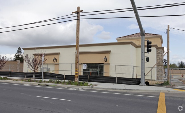


This Property Is For Sale
Property Detail
1070 Laurel Rd
Oakland-Fremont-Berkeley, CA
T9188 L2
035-510-003-3
CONTRA COSTA
Regionalshoppingcenterormallwithanchorstore
California
B and X Area of moderate flood hazard, usually the area between the limits of the 100-year and 500-year floods.
2
2025
0.79 AC
2025
Antioch/Pittsburg
302014
East Bay/Oakland
3,860 SF
NEARBY LISTINGS FOR SALE OR LEASE
DEMOGRAPHICS near 1070 Laurel Rd
1 mile
3 mile
5 mile
2025 Total Population
15,721
88,406
180,746
2030 Population
15,961
90,246
183,529
Pop Growth 2025-2030
+ 1.53%
+ 2.08%
+ 1.54%
Average Age
38
38
39
2025 Total Households
4,705
26,115
55,246
HH Growth 2025-2030
+ 1.55%
+ 2.09%
+ 1.56%
Median Household Inc
$131,896
$131,834
$125,383
Avg Household Size
3.30
3.30
3.20
2025 Avg HH Vehicles
3.00
3.00
2.00
Median Home Value
$700,151
$747,271
$739,962
Median Year Built
1990
1999
1996
Nearby Places
Map Layers
Map Styles
 Street
 Aerial
Transit
 Traffic
 Biking
Places
Listings with unknown addresses are not visible on the map
- Restaurants
- Banks
- Shops
- Fitness
- Groceries
PUBLIC TRANSPORTATION
AIRPORT
Stockton Metro
Drive
Walk
Distance
Stockton Metro
55 min
38.3 mi
Metro Oakland International
Drive
Walk
Distance
Metro Oakland International
64 min
49.3 mi
Freight Ports
Port of Stockton
Drive
Walk
Distance
Port of Stockton
51 min
35.7 mi
Nearby Properties
Address
Land Use
TOTAL SIZE
Lot Size
Zoning
Address
Land Use
TOTAL SIZE
Lot Size
Zoning
24,286 SF
13.89 AC
Address
Land Use
TOTAL SIZE
Lot Size
Zoning
9,999 SF
32.23 AC
Address
Land Use
TOTAL SIZE
Lot Size
Zoning
39,038 SF
14.43 AC
Address
Land Use
TOTAL SIZE
Lot Size
Zoning
55.08 AC
Address
Land Use
TOTAL SIZE
Lot Size
Zoning
14,968 SF
7.07 AC
Address
Land Use
TOTAL SIZE
Lot Size
Zoning
479,414 SF
30.53 AC
Address
Land Use
TOTAL SIZE
Lot Size
Zoning
28,078 SF
6.46 AC
Address
Land Use
TOTAL SIZE
Lot Size
Zoning
67,691 SF
28.26 AC
Address
Land Use
TOTAL SIZE
Lot Size
Zoning
308.96 AC
Address
Land Use
TOTAL SIZE
Lot Size
Zoning
67,133 SF
8.65 AC
Address
Land Use
TOTAL SIZE
Lot Size
Zoning
449,174 SF
38.31 AC
Address
Land Use
TOTAL SIZE
Lot Size
Zoning
145,503 SF
25.05 AC
Address
Land Use
TOTAL SIZE
Lot Size
Zoning
220,840 SF
13.67 AC
Address
Land Use
TOTAL SIZE
Lot Size
Zoning
15,000 SF
17.17 AC
Address
Land Use
TOTAL SIZE
Lot Size
Zoning
443,591 SF
23.43 AC
Address
Land Use
TOTAL SIZE
Lot Size
Zoning
115,013 SF
6.54 AC
Address
Land Use
TOTAL SIZE
Lot Size
Zoning
97,310 SF
5.85 AC
Address
Land Use
TOTAL SIZE
Lot Size
Zoning
113,902 SF
9.71 AC
Address
Land Use
TOTAL SIZE
Lot Size
Zoning
157,933 SF
19.04 AC
Address
Land Use
TOTAL SIZE
Lot Size
Zoning
168,442 SF
17.46 AC
Address
Land Use
TOTAL SIZE
Lot Size
Zoning
184,623 SF
6.59 AC
Address
Land Use
TOTAL SIZE
Lot Size
Zoning
12,410 SF
5.38 AC
Address
Land Use
TOTAL SIZE
Lot Size
Zoning
40,054 SF
3.39 AC
Address
Land Use
TOTAL SIZE
Lot Size
Zoning
24,156 SF
14.47 AC
Address
Land Use
TOTAL SIZE
Lot Size
Zoning
13,468 SF
8.77 AC
Address
Land Use
TOTAL SIZE
Lot Size
Zoning
126,509 SF
11.47 AC
Address
Land Use
TOTAL SIZE
Lot Size
Zoning
147,868 SF
7.83 AC
Address
Land Use
TOTAL SIZE
Lot Size
Zoning
23,822 SF
7.16 AC
Address
Land Use
TOTAL SIZE
Lot Size
Zoning
40,995 SF
10.59 AC
Address
Land Use
TOTAL SIZE
Lot Size
Zoning
96,956 SF
10.49 AC
The World's #1 Commercial Real Estate Marketplace
Connect with us
© 2026 CoStar Group
The information above has been obtained from sources believed reliable. While we do not doubt its accuracy we have not verified it and make no guarantee, warranty or representation about it. It is your responsibility to independently confirm its accuracy and completeness. Any projections, opinions, assumptions, or estimates used are for example only and do not represent the current or future performance of the property. The value of this transaction to you depends on tax and other factors which should be evaluated by your tax, financial, and legal advisors. You and your advisors should conduct a careful, independent investigation of the property to determine to your satisfaction the suitability of the property for your needs.