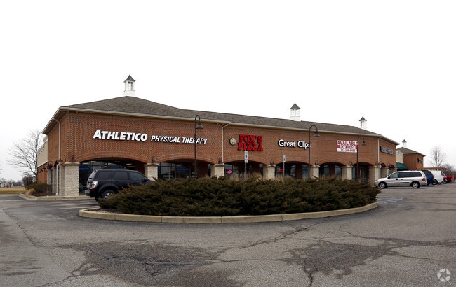
Property Record
1070 W Main St, Plainfield, IN 46168
NEARBY LISTINGS FOR SALE OR LEASE
Property Detail
1070 W Main St
32-10-34-108-001.000-012
Saratoga Commercial
Stripcommercialcenter
SARATOGA COMMERCIAL BLOCK A 0.47AC DBA : ROAD
X
Hendricks
18109C0025E
Indiana
2024
2.35 AC
2024
Hendricks County
210802
Indianapolis
20,469 SF
Indianapolis-Carmel-Greenwood, IN
DEMOGRAPHICS near 1070 W Main St
1 Mile
3 Mile
5 Mile
2024 Total Population
7,995
38,636
64,218
2029 Population
8,985
43,186
71,821
Pop Growth 2024-2029
+ 12.38%
+ 11.78%
+ 11.84%
Average Age
39
40
40
2024 Total Households
3,147
14,162
23,721
HH Growth 2024-2029
+ 12.58%
+ 11.95%
+ 11.95%
Median Household Inc
$78,536
$81,681
$88,346
Avg Household Size
2.50
2.50
2.50
2024 Avg HH Vehicles
2.00
2.00
2.00
Median Home Value
$245,890
$245,880
$249,557
Median Year Built
2002
1993
1995
Nearby Places
Map Layers
Map Styles
 Street
 Aerial
- Restaurants
- Banks
- Shops
- Fitness
- Groceries
PUBLIC TRANSPORTATION
AIRPORT
Indianapolis International
DRIVE
WALK
Distance
Indianapolis International
20 min
9.7 mi
SALE & LEASE HISTORY
LISTING DATE
SALE/LEASE

Sep 25, 2016
For Lease
Sep 25, 2016
For Lease
Nov 18, 2022
For Lease
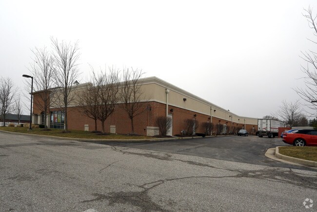
Nearby Properties
Address
Land Use
TOTAL SIZE
Lot Size
Zoning
Address
Land Use
TOTAL SIZE
Lot Size
Zoning
750,820 SF
64.15 AC
Address
Land Use
TOTAL SIZE
Lot Size
Zoning
10,953 SF
18.52 AC
Address
Land Use
TOTAL SIZE
Lot Size
Zoning
518,536 SF
25.66 AC
Address
Land Use
TOTAL SIZE
Lot Size
Zoning
599,744 SF
34.65 AC
Address
Land Use
TOTAL SIZE
Lot Size
Zoning
3,443 SF
15.82 AC
Address
Land Use
TOTAL SIZE
Lot Size
Zoning
357,000 SF
27.34 AC
Address
Land Use
TOTAL SIZE
Lot Size
Zoning
Address
Land Use
TOTAL SIZE
Lot Size
Zoning
4,933 SF
20.70 AC
Address
Land Use
TOTAL SIZE
Lot Size
Zoning
2.31 AC
Address
Land Use
TOTAL SIZE
Lot Size
Zoning
2,811 SF
14.97 AC
Address
Land Use
TOTAL SIZE
Lot Size
Zoning
235,986 SF
34.02 AC
Address
Land Use
TOTAL SIZE
Lot Size
Zoning
354,573 SF
70.34 AC
Address
Land Use
TOTAL SIZE
Lot Size
Zoning
16,224 SF
14.08 AC
Address
Land Use
TOTAL SIZE
Lot Size
Zoning
81,910 SF
10.62 AC
Address
Land Use
TOTAL SIZE
Lot Size
Zoning
146,051 SF
13.77 AC
Address
Land Use
TOTAL SIZE
Lot Size
Zoning
6,128 SF
17.41 AC
Address
Land Use
TOTAL SIZE
Lot Size
Zoning
192,212 SF
30.87 AC
Address
Land Use
TOTAL SIZE
Lot Size
Zoning
220,371 SF
22.56 AC
Address
Land Use
TOTAL SIZE
Lot Size
Zoning
67,502 SF
5.06 AC
Address
Land Use
TOTAL SIZE
Lot Size
Zoning
96,288 SF
0.84 AC
Address
Land Use
TOTAL SIZE
Lot Size
Zoning
79,540 SF
12.93 AC
Address
Land Use
TOTAL SIZE
Lot Size
Zoning
76,132 SF
3.74 AC
Address
Land Use
TOTAL SIZE
Lot Size
Zoning
703 SF
8.30 AC
Address
Land Use
TOTAL SIZE
Lot Size
Zoning
63,599 SF
3.88 AC
Address
Land Use
TOTAL SIZE
Lot Size
Zoning
18,572 SF
13.54 AC
Address
Land Use
TOTAL SIZE
Lot Size
Zoning
10,953 SF
4.37 AC
Address
Land Use
TOTAL SIZE
Lot Size
Zoning
102,718 SF
7 AC
Address
Land Use
TOTAL SIZE
Lot Size
Zoning
11,538 SF
14.30 AC
Address
Land Use
TOTAL SIZE
Lot Size
Zoning
49,984 SF
5.59 AC
Address
Land Use
TOTAL SIZE
Lot Size
Zoning
92,412 SF
5.61 AC
The World's #1 Commercial Real Estate Marketplace
Connect with us
© 2026 CoStar Group
The information above has been obtained from sources believed reliable. While we do not doubt its accuracy we have not verified it and make no guarantee, warranty or representation about it. It is your responsibility to independently confirm its accuracy and completeness. Any projections, opinions, assumptions, or estimates used are for example only and do not represent the current or future performance of the property. The value of this transaction to you depends on tax and other factors which should be evaluated by your tax, financial, and legal advisors. You and your advisors should conduct a careful, independent investigation of the property to determine to your satisfaction the suitability of the property for your needs.