Property Record
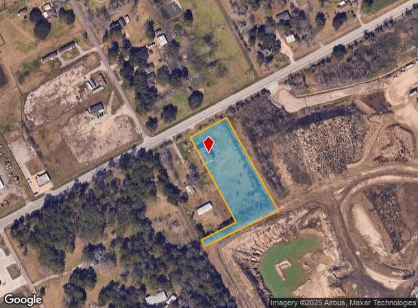
10700 E Fm 1462 Rd, Alvin, TX 77511

NEARBY LISTINGS FOR SALE OR LEASE
Property Detail
10700 E Fm 1462 Rd
Houston-The Woodlands-Sugar Land, TX
Masterson (A0100 F Moore)
6436-0008-000
MASTERSON (A0100 F MOORE) LOT 1A ACRES 2.9
Agriculturalland
Brazoria
X
Texas
48039C0145K
1a
2024
2.90 AC
2025
South Hwy 35
661400
Houston
DEMOGRAPHICS near 10700 E Fm 1462 Rd
1 Mile
3 Mile
5 Mile
2024 Total Population
1,017
12,717
40,640
2029 Population
1,122
14,149
45,271
Pop Growth 2024-2029
+ 10.32%
+ 11.26%
+ 11.40%
Average Age
39
38
38
2024 Total Households
344
4,375
14,537
HH Growth 2024-2029
+ 10.47%
+ 11.41%
+ 11.52%
Median Household Inc
$83,796
$63,756
$64,968
Avg Household Size
2.90
2.80
2.70
2024 Avg HH Vehicles
2.00
2.00
2.00
Median Home Value
$247,297
$184,015
$196,637
Median Year Built
1987
1984
1985
Nearby Places
Map Layers
Map Styles
 Street
 Aerial
- Restaurants
- Banks
- Shops
- Fitness
- Groceries
PUBLIC TRANSPORTATION
AIRPORT
William P Hobby
DRIVE
WALK
Distance
William P Hobby
39 min
22.1 mi
Freight Ports
Port of Houston
DRIVE
WALK
Distance
Port of Houston
50 min
30.2 mi
SALE & LEASE HISTORY
LISTING DATE
SALE/LEASE

Jun 03, 2019
For Sale
Nearby Properties
Address
Land Use
TOTAL SIZE
Lot Size
Zoning
Address
Land Use
TOTAL SIZE
Lot Size
Zoning
64,082 SF
17.62 AC
Address
Land Use
TOTAL SIZE
Lot Size
Zoning
66,557 SF
8.99 AC
0065
Address
Land Use
TOTAL SIZE
Lot Size
Zoning
100,453 SF
6.02 AC
Address
Land Use
TOTAL SIZE
Lot Size
Zoning
81,272 SF
5.03 AC
0015
Address
Land Use
TOTAL SIZE
Lot Size
Zoning
52,352 SF
2.27 AC
Address
Land Use
TOTAL SIZE
Lot Size
Zoning
70.66 AC
Address
Land Use
TOTAL SIZE
Lot Size
Zoning
39,420 SF
5 AC
Address
Land Use
TOTAL SIZE
Lot Size
Zoning
9,979 SF
5.37 AC
Address
Land Use
TOTAL SIZE
Lot Size
Zoning
61,432 SF
25 AC
Address
Land Use
TOTAL SIZE
Lot Size
Zoning
5,100 SF
17.17 AC
Address
Land Use
TOTAL SIZE
Lot Size
Zoning
18,600 SF
55 AC
0017
Address
Land Use
TOTAL SIZE
Lot Size
Zoning
16,920 SF
2.65 AC
Address
Land Use
TOTAL SIZE
Lot Size
Zoning
7,320 SF
1.07 AC
Address
Land Use
TOTAL SIZE
Lot Size
Zoning
9,100 SF
1.82 AC
Address
Land Use
TOTAL SIZE
Lot Size
Zoning
28,274 SF
4.80 AC
Address
Land Use
TOTAL SIZE
Lot Size
Zoning
1,785 SF
10.35 AC
Address
Land Use
TOTAL SIZE
Lot Size
Zoning
17,030 SF
9.83 AC
0080
Address
Land Use
TOTAL SIZE
Lot Size
Zoning
11,900 SF
20 AC
0030
Address
Land Use
TOTAL SIZE
Lot Size
Zoning
13,160 SF
12.20 AC
0071
Address
Land Use
TOTAL SIZE
Lot Size
Zoning
11,925 SF
4.98 AC
Address
Land Use
TOTAL SIZE
Lot Size
Zoning
5,871 SF
1.79 AC
Address
Land Use
TOTAL SIZE
Lot Size
Zoning
15,640 SF
9.16 AC
0028
Address
Land Use
TOTAL SIZE
Lot Size
Zoning
13,366 SF
7.08 AC
Address
Land Use
TOTAL SIZE
Lot Size
Zoning
3,178 SF
1.01 AC
Address
Land Use
TOTAL SIZE
Lot Size
Zoning
12,675 SF
5 AC
Address
Land Use
TOTAL SIZE
Lot Size
Zoning
10,710 SF
5.97 AC
Address
Land Use
TOTAL SIZE
Lot Size
Zoning
58 SF
6.04 AC
Address
Land Use
TOTAL SIZE
Lot Size
Zoning
9,045 SF
5.66 AC
Address
Land Use
TOTAL SIZE
Lot Size
Zoning
60.08 AC
0024
Address
Land Use
TOTAL SIZE
Lot Size
Zoning
6,892 SF
25.01 AC
The World's #1 Commercial Real Estate Marketplace
Connect with us
© 2025 CoStar Group
The information above has been obtained from sources believed reliable. While we do not doubt its accuracy we have not verified it and make no guarantee, warranty or representation about it. It is your responsibility to independently confirm its accuracy and completeness. Any projections, opinions, assumptions, or estimates used are for example only and do not represent the current or future performance of the property. The value of this transaction to you depends on tax and other factors which should be evaluated by your tax, financial, and legal advisors. You and your advisors should conduct a careful, independent investigation of the property to determine to your satisfaction the suitability of the property for your needs.