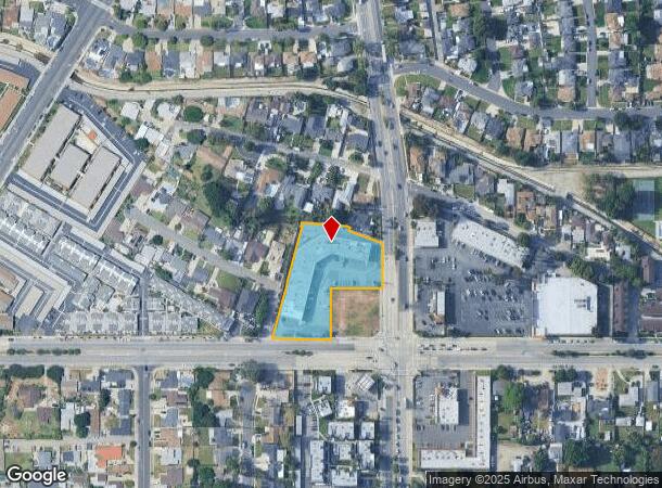
Property Record
10701 La Mirada Blvd, Whittier, CA 90604
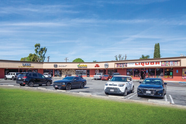
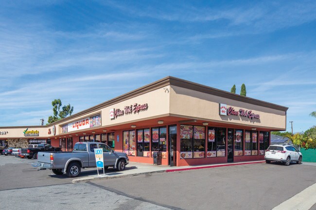

This Property Is For Sale
NEARBY LISTINGS FOR SALE OR LEASE
Property Detail
10701 La Mirada Blvd
Los Angeles-Long Beach-Glendale, CA
The Corona Tract
8226-022-042
CORONA TRACT LOT COM E ON N LINE OF MULBERRY DR 20.33 FT FROM INTERSECTION OF SD N LINE WITH SW LINE OF LAND DESC IN CERT NO QB 31654 TO PHILIP GRAETCH TH N 14 22 E 344.12 FT TH N 85 33 W 8.43 TH W THEREON TO BEG PART OF LOT 4
Storemultistory
Los Angeles
X
California
06037C1842F
4
2024
1.61 AC
2025
Southeast Los Angeles
503501
Los Angeles
21,330 SF
DEMOGRAPHICS near 10701 La Mirada Blvd
1 Mile
3 Mile
5 Mile
2024 Total Population
27,954
173,918
441,585
2029 Population
27,004
168,191
427,849
Pop Growth 2024-2029
(3.40%)
(3.29%)
(3.11%)
Average Age
39
40
40
2024 Total Households
8,403
52,557
133,829
HH Growth 2024-2029
(3.67%)
(3.53%)
(3.34%)
Median Household Inc
$98,550
$94,468
$92,101
Avg Household Size
3.30
3.20
3.20
2024 Avg HH Vehicles
2.00
2.00
2.00
Median Home Value
$725,902
$737,534
$725,891
Median Year Built
1956
1957
1960
Nearby Places
Map Layers
Map Styles
 Street
 Aerial
- Restaurants
- Banks
- Shops
- Fitness
- Groceries
PUBLIC TRANSPORTATION
COMMUTER RAIL
Norwalk/Santa Fe Springs (91 Line - Southern California Regional Rail Authority (Metrolink), Orange County Line - Southern California Regional Rail Authority (Metrolink))
DRIVE
WALK
Distance
Norwalk/Santa Fe Springs (91 Line - Southern California Regional Rail Authority (Metrolink), Orange County Line - Southern California Regional Rail Authority (Metrolink))
7 min
3.6 mi
Buena Park (91 Line - Southern California Regional Rail Authority (Metrolink), Orange County Line - Southern California Regional Rail Authority (Metrolink))
DRIVE
WALK
Distance
Buena Park (91 Line - Southern California Regional Rail Authority (Metrolink), Orange County Line - Southern California Regional Rail Authority (Metrolink))
8 min
4.9 mi
AIRPORT
Long Beach (Daugherty Field)
DRIVE
WALK
Distance
Long Beach (Daugherty Field)
29 min
17.4 mi
John Wayne/Orange County
DRIVE
WALK
Distance
John Wayne/Orange County
31 min
23.9 mi
Los Angeles International
DRIVE
WALK
Distance
Los Angeles International
35 min
25.5 mi
Freight Ports
Port of Long Beach
DRIVE
WALK
Distance
Port of Long Beach
34 min
22.0 mi
Nearby Properties
Address
Land Use
TOTAL SIZE
Lot Size
Zoning
Address
Land Use
TOTAL SIZE
Lot Size
Zoning
1,100,900 SF
22.36 AC
SSM2*
Address
Land Use
TOTAL SIZE
Lot Size
Zoning
150,561 SF
65.24 AC
LMPUD
Address
Land Use
TOTAL SIZE
Lot Size
Zoning
564,705 SF
14.35 AC
LCA25*
Address
Land Use
TOTAL SIZE
Lot Size
Zoning
10.49 AC
Address
Land Use
TOTAL SIZE
Lot Size
Zoning
322,048 SF
15.54 AC
SSM2-M1*
Address
Land Use
TOTAL SIZE
Lot Size
Zoning
128,481 SF
19.42 AC
LMR1*
Address
Land Use
TOTAL SIZE
Lot Size
Zoning
300,148 SF
13.01 AC
SSM2*
Address
Land Use
TOTAL SIZE
Lot Size
Zoning
10.49 AC
Address
Land Use
TOTAL SIZE
Lot Size
Zoning
89,899 SF
SSM2*
Address
Land Use
TOTAL SIZE
Lot Size
Zoning
834,952 SF
33.06 AC
SSM2
Address
Land Use
TOTAL SIZE
Lot Size
Zoning
89,514 SF
21.28 AC
WHC2*
Address
Land Use
TOTAL SIZE
Lot Size
Zoning
85,245 SF
7.44 AC
WHT*
Address
Land Use
TOTAL SIZE
Lot Size
Zoning
425,816 SF
30.02 AC
SSM2*
Address
Land Use
TOTAL SIZE
Lot Size
Zoning
62,612 SF
21.49 AC
SSM2
Address
Land Use
TOTAL SIZE
Lot Size
Zoning
145,372 SF
7.21 AC
SSM2*
Address
Land Use
TOTAL SIZE
Lot Size
Zoning
184,230 SF
4.55 AC
SSM2*
Address
Land Use
TOTAL SIZE
Lot Size
Zoning
161,861 SF
17.50 AC
SSC4PD*
Address
Land Use
TOTAL SIZE
Lot Size
Zoning
147,531 SF
6.53 AC
SSM2*
Address
Land Use
TOTAL SIZE
Lot Size
Zoning
268,536 SF
12.25 AC
SSM2*
Address
Land Use
TOTAL SIZE
Lot Size
Zoning
916,869 SF
21.34 AC
SSM2*
Address
Land Use
TOTAL SIZE
Lot Size
Zoning
397,560 SF
8.25 AC
SSM2*
Address
Land Use
TOTAL SIZE
Lot Size
Zoning
Address
Land Use
TOTAL SIZE
Lot Size
Zoning
216,952 SF
23.54 AC
WHR4*
Address
Land Use
TOTAL SIZE
Lot Size
Zoning
96,802 SF
4.93 AC
Address
Land Use
TOTAL SIZE
Lot Size
Zoning
41,430 SF
5.85 AC
Address
Land Use
TOTAL SIZE
Lot Size
Zoning
67,692 SF
2.34 AC
WHC2*
Address
Land Use
TOTAL SIZE
Lot Size
Zoning
14.86 AC
Address
Land Use
TOTAL SIZE
Lot Size
Zoning
13.60 AC
Address
Land Use
TOTAL SIZE
Lot Size
Zoning
151,618 SF
7.70 AC
WHM1*
Address
Land Use
TOTAL SIZE
Lot Size
Zoning
69,056 SF
2.25 AC
WHM1*
The World's #1 Commercial Real Estate Marketplace
Connect with us
© 2026 CoStar Group
The information above has been obtained from sources believed reliable. While we do not doubt its accuracy we have not verified it and make no guarantee, warranty or representation about it. It is your responsibility to independently confirm its accuracy and completeness. Any projections, opinions, assumptions, or estimates used are for example only and do not represent the current or future performance of the property. The value of this transaction to you depends on tax and other factors which should be evaluated by your tax, financial, and legal advisors. You and your advisors should conduct a careful, independent investigation of the property to determine to your satisfaction the suitability of the property for your needs.