Property Record
10701 E 120Th Ave, Henderson, CO 80640


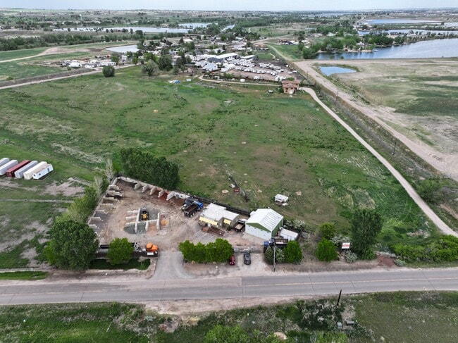
This Property Is For Sale
Property Detail
10701 E 120Th Ave
1571-34-0-00-035
SECT,TWN,RNG:34-1-67 DESC: PT OF THE SE4 OF THE SE4 OF SEC 34 DESC AS FOLS BEG AT THE SE COR OF SD SE4 TH N 89D 54M 30S W 65/5 FT TO THE TRUE POB TH CONT S 89D 54M 30S W 369 FT TH N 00D 05M 30S W 217/14 FT TH S 59D 37M E 428/15 FT TO THE TRUE POB 1A
Miscellaneous
Adams
A3
Colorado
B and X Area of moderate flood hazard, usually the area between the limits of the 100-year and 500-year floods.
1 AC
2024
DIA
2025
Denver
008535
Denver-Aurora-Centennial, CO
1,848 SF
NEARBY LISTINGS FOR SALE OR LEASE
DEMOGRAPHICS near 10701 E 120Th Ave
1 mile
3 mile
5 mile
2025 Total Population
4,347
36,256
138,905
2030 Population
4,473
37,875
144,877
Pop Growth 2025-2030
+ 2.90%
+ 4.47%
+ 4.30%
Average Age
35
35
37
2025 Total Households
1,327
11,357
46,129
HH Growth 2025-2030
+ 3.24%
+ 4.72%
+ 4.62%
Median Household Inc
$124,023
$133,636
$122,863
Avg Household Size
3.30
3.20
3.00
2025 Avg HH Vehicles
2.00
2.00
2.00
Median Home Value
$502,289
$611,249
$588,833
Median Year Built
2005
2006
2002
Nearby Places
Map Layers
Map Styles
 Street
 Aerial
Transit
 Traffic
 Biking
Places
Listings with unknown addresses are not visible on the map
- Restaurants
- Banks
- Shops
- Fitness
- Groceries
PUBLIC TRANSPORTATION
COMMUTER RAIL
Drive
Walk
Distance
11 min
5.5 mi
Drive
Walk
Distance
11 min
5.7 mi
AIRPORT
Denver International
Drive
Walk
Distance
Denver International
24 min
18.4 mi
Nearby Properties
Address
Land Use
TOTAL SIZE
Lot Size
Zoning
Address
Land Use
TOTAL SIZE
Lot Size
Zoning
8,556 SF
382.73 AC
A3
Address
Land Use
TOTAL SIZE
Lot Size
Zoning
358,386 SF
76.08 AC
Address
Land Use
TOTAL SIZE
Lot Size
Zoning
276,395 SF
26.43 AC
A3
Address
Land Use
TOTAL SIZE
Lot Size
Zoning
330,176 SF
17.12 AC
Address
Land Use
TOTAL SIZE
Lot Size
Zoning
298,200 SF
17.67 AC
Address
Land Use
TOTAL SIZE
Lot Size
Zoning
272,800 SF
16.44 AC
Address
Land Use
TOTAL SIZE
Lot Size
Zoning
109,685 SF
11.51 AC
Address
Land Use
TOTAL SIZE
Lot Size
Zoning
64,750 SF
11.91 AC
Address
Land Use
TOTAL SIZE
Lot Size
Zoning
158,001 SF
20.40 AC
Address
Land Use
TOTAL SIZE
Lot Size
Zoning
Address
Land Use
TOTAL SIZE
Lot Size
Zoning
96,628 SF
4.35 AC
Address
Land Use
TOTAL SIZE
Lot Size
Zoning
174.45 AC
Address
Land Use
TOTAL SIZE
Lot Size
Zoning
207,453 SF
26.66 AC
Address
Land Use
TOTAL SIZE
Lot Size
Zoning
64,501 SF
29.37 AC
Address
Land Use
TOTAL SIZE
Lot Size
Zoning
121,275 SF
6.56 AC
Address
Land Use
TOTAL SIZE
Lot Size
Zoning
48,359 SF
278.79 AC
A3
Address
Land Use
TOTAL SIZE
Lot Size
Zoning
64,715 SF
10.38 AC
Address
Land Use
TOTAL SIZE
Lot Size
Zoning
106,530 SF
7.04 AC
Address
Land Use
TOTAL SIZE
Lot Size
Zoning
70,573 SF
6.42 AC
Address
Land Use
TOTAL SIZE
Lot Size
Zoning
33,989 SF
24.98 AC
Address
Land Use
TOTAL SIZE
Lot Size
Zoning
63,602 SF
10.09 AC
Address
Land Use
TOTAL SIZE
Lot Size
Zoning
63,989 SF
12.74 AC
Address
Land Use
TOTAL SIZE
Lot Size
Zoning
89,219 SF
11.79 AC
Address
Land Use
TOTAL SIZE
Lot Size
Zoning
56,697 SF
9.97 AC
PUD
Address
Land Use
TOTAL SIZE
Lot Size
Zoning
44,090 SF
20.72 AC
Address
Land Use
TOTAL SIZE
Lot Size
Zoning
55,810 SF
14.52 AC
Address
Land Use
TOTAL SIZE
Lot Size
Zoning
82,239 SF
7.02 AC
Address
Land Use
TOTAL SIZE
Lot Size
Zoning
79,121 SF
6.39 AC
Address
Land Use
TOTAL SIZE
Lot Size
Zoning
75,398 SF
8.82 AC
I2
Address
Land Use
TOTAL SIZE
Lot Size
Zoning
106.69 AC
RE
The World's #1 Commercial Real Estate Marketplace
Connect with us
© 2026 CoStar Group
The information above has been obtained from sources believed reliable. While we do not doubt its accuracy we have not verified it and make no guarantee, warranty or representation about it. It is your responsibility to independently confirm its accuracy and completeness. Any projections, opinions, assumptions, or estimates used are for example only and do not represent the current or future performance of the property. The value of this transaction to you depends on tax and other factors which should be evaluated by your tax, financial, and legal advisors. You and your advisors should conduct a careful, independent investigation of the property to determine to your satisfaction the suitability of the property for your needs.