Property Record
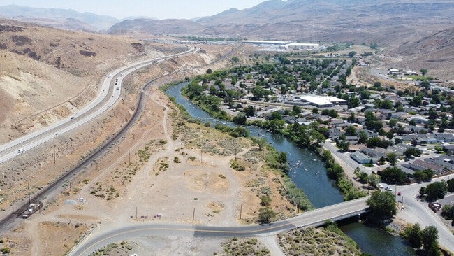
10705 Lockwood Dr, Sparks, NV 89434


Current Lease Availabilities
NEARBY LISTINGS FOR SALE OR LEASE
Property Detail
10705 Lockwood Dr
Reno, NV
_Unspecified
084-080-15
FRAC SEC 16 & 17 TWP 19N RGE 21E
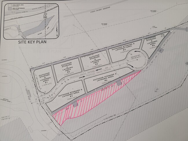
Industrialacreage
Washoe
AE
Nevada
32031C3069G
null
2025
5.65 AC
2026
Storey County
003109
Reno/Sparks
DEMOGRAPHICS near 10705 Lockwood Dr
1 Mile
3 Mile
5 Mile
2024 Total Population
1,195
1,215
28,737
2029 Population
1,264
1,286
30,396
Pop Growth 2024-2029
+ 5.77%
+ 5.84%
+ 5.77%
Average Age
46
46
42
2024 Total Households
512
519
12,097
HH Growth 2024-2029
+ 5.47%
+ 5.78%
+ 6.24%
Median Household Inc
$42,380
$42,420
$75,506
Avg Household Size
2.30
2.30
2.30
2024 Avg HH Vehicles
1.00
2.00
2.00
Median Home Value
$226,704
$227,170
$425,906
Median Year Built
1992
1992
1990
Nearby Places
Map Layers
Map Styles
 Street
 Aerial
- Restaurants
- Banks
- Shops
- Fitness
- Groceries
PUBLIC TRANSPORTATION
AIRPORT
Reno/Tahoe International
DRIVE
WALK
Distance
Reno/Tahoe International
33 min
13.9 mi
Nearby Properties
Address
Land Use
TOTAL SIZE
Lot Size
Zoning
Address
Land Use
TOTAL SIZE
Lot Size
Zoning
561,000 SF
45.75 AC
I
Address
Land Use
TOTAL SIZE
Lot Size
Zoning
351,452 SF
71.90 AC
I
Address
Land Use
TOTAL SIZE
Lot Size
Zoning
53,248 SF
19.50 AC
I
Address
Land Use
TOTAL SIZE
Lot Size
Zoning
45,150 SF
4.50 AC
I
Address
Land Use
TOTAL SIZE
Lot Size
Zoning
47,888 SF
2.30 AC
NUD
Address
Land Use
TOTAL SIZE
Lot Size
Zoning
12,156 SF
1,534.49 AC
I-2;INDUST
Address
Land Use
TOTAL SIZE
Lot Size
Zoning
57,392 SF
7.08 AC
I
Address
Land Use
TOTAL SIZE
Lot Size
Zoning
64,539 SF
10 AC
I2
Address
Land Use
TOTAL SIZE
Lot Size
Zoning
99.81 AC
GR
Address
Land Use
TOTAL SIZE
Lot Size
Zoning
127,000 SF
7.15 AC
I
Address
Land Use
TOTAL SIZE
Lot Size
Zoning
80,879 SF
8.75 AC
I-1;INDUST
Address
Land Use
TOTAL SIZE
Lot Size
Zoning
47,616 SF
5.89 AC
I
Address
Land Use
TOTAL SIZE
Lot Size
Zoning
1,280 SF
43.32 AC
I
Address
Land Use
TOTAL SIZE
Lot Size
Zoning
2,680 SF
36.57 AC
I
Address
Land Use
TOTAL SIZE
Lot Size
Zoning
5,250 SF
14.78 AC
I
Address
Land Use
TOTAL SIZE
Lot Size
Zoning
31,440 SF
29.38 AC
GR
Address
Land Use
TOTAL SIZE
Lot Size
Zoning
30,368 SF
5.03 AC
I
Address
Land Use
TOTAL SIZE
Lot Size
Zoning
24,350 SF
4.97 AC
I
Address
Land Use
TOTAL SIZE
Lot Size
Zoning
16,620 SF
4.58 AC
I
Address
Land Use
TOTAL SIZE
Lot Size
Zoning
8,715 SF
30.03 AC
Address
Land Use
TOTAL SIZE
Lot Size
Zoning
8,500 SF
35.23 AC
P
Address
Land Use
TOTAL SIZE
Lot Size
Zoning
8,324.70 AC
F
Address
Land Use
TOTAL SIZE
Lot Size
Zoning
9,120 SF
6.75 AC
I
Address
Land Use
TOTAL SIZE
Lot Size
Zoning
1.18 AC
F;FORESTED
Address
Land Use
TOTAL SIZE
Lot Size
Zoning
21.81 AC
I 95%/RDS
Address
Land Use
TOTAL SIZE
Lot Size
Zoning
2.78 AC
PUD /;PUB
Address
Land Use
TOTAL SIZE
Lot Size
Zoning
20,000 SF
2.56 AC
I
Address
Land Use
TOTAL SIZE
Lot Size
Zoning
17,960 SF
2.04 AC
I
Address
Land Use
TOTAL SIZE
Lot Size
Zoning
9,900 SF
3.02 AC
I
Address
Land Use
TOTAL SIZE
Lot Size
Zoning
7,700 SF
2.68 AC
I
The World's #1 Commercial Real Estate Marketplace
Connect with us
© 2025 CoStar Group
The information above has been obtained from sources believed reliable. While we do not doubt its accuracy we have not verified it and make no guarantee, warranty or representation about it. It is your responsibility to independently confirm its accuracy and completeness. Any projections, opinions, assumptions, or estimates used are for example only and do not represent the current or future performance of the property. The value of this transaction to you depends on tax and other factors which should be evaluated by your tax, financial, and legal advisors. You and your advisors should conduct a careful, independent investigation of the property to determine to your satisfaction the suitability of the property for your needs.