Property Record
1071 S Toledo Blade Blvd, North Port, FL 34288

NEARBY LISTINGS FOR SALE OR LEASE
-
-
S Toledo Blade & Price Lane Junction
North Port, FL 34288
Rent Upon Request
28.97 - 31.97 AC Lot
Land
-
-
-
-
-
-
View all North Port listings for sale on LoopNet.com
Property Detail
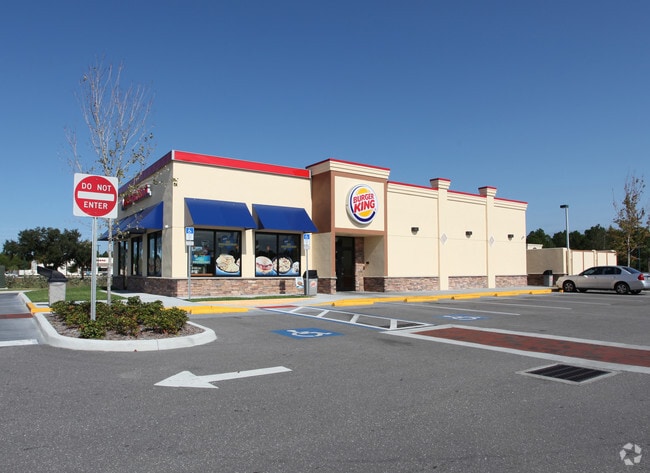
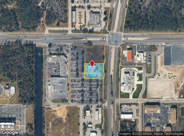
1071 S Toledo Blade Blvd
North Port-Sarasota-Bradenton, FL
Price Crossing
0984-05-0020
PARCEL 2, PRICE CROSSINGS
Restaurantbuilding
Sarasota
X
Florida
12115C0383F
parce
2024
0.87 AC
2025
Sarasota Outlying
002742
Tampa/St Petersburg
3,475 SF
DEMOGRAPHICS near 1071 S Toledo Blade Blvd
1 Mile
3 Mile
5 Mile
2024 Total Population
4,471
38,786
72,552
2029 Population
5,176
44,657
84,085
Pop Growth 2024-2029
+ 15.77%
+ 15.14%
+ 15.90%
Average Age
41
42
44
2024 Total Households
1,654
14,378
28,433
HH Growth 2024-2029
+ 15.60%
+ 15.09%
+ 16.03%
Median Household Inc
$101,673
$78,302
$68,541
Avg Household Size
2.60
2.60
2.50
2024 Avg HH Vehicles
2.00
2.00
2.00
Median Home Value
$255,235
$255,711
$246,907
Median Year Built
2005
2004
2002
Nearby Places
Map Layers
Map Styles
 Street
 Aerial
- Restaurants
- Banks
- Shops
- Fitness
- Groceries
PUBLIC TRANSPORTATION
AIRPORT
Punta Gorda
DRIVE
WALK
Distance
Punta Gorda
28 min
20.7 mi
Sarasota/Bradenton International
DRIVE
WALK
Distance
Sarasota/Bradenton International
59 min
45.1 mi
Freight Ports
Port Manatee
DRIVE
WALK
Distance
Port Manatee
70 min
57.6 mi
Nearby Properties
Address
Land Use
TOTAL SIZE
Lot Size
Zoning
Address
Land Use
TOTAL SIZE
Lot Size
Zoning
316,994 SF
40.88 AC
V
Address
Land Use
TOTAL SIZE
Lot Size
Zoning
218,356 SF
17.14 AC
AC2
Address
Land Use
TOTAL SIZE
Lot Size
Zoning
287,899 SF
26.96 AC
AC4
Address
Land Use
TOTAL SIZE
Lot Size
Zoning
262,144 SF
18.13 AC
AC5
Address
Land Use
TOTAL SIZE
Lot Size
Zoning
285,000 SF
148.79 AC
AC4
Address
Land Use
TOTAL SIZE
Lot Size
Zoning
145,713 SF
30.50 AC
GU
Address
Land Use
TOTAL SIZE
Lot Size
Zoning
159,624 SF
57.12 AC
AC4
Address
Land Use
TOTAL SIZE
Lot Size
Zoning
54,876 SF
23.57 AC
AC4
Address
Land Use
TOTAL SIZE
Lot Size
Zoning
233,560 SF
46.42 AC
AC5
Address
Land Use
TOTAL SIZE
Lot Size
Zoning
114,985 SF
29.77 AC
GU
Address
Land Use
TOTAL SIZE
Lot Size
Zoning
72,301 SF
11.72 AC
AC5
Address
Land Use
TOTAL SIZE
Lot Size
Zoning
94,423 SF
12.87 AC
V
Address
Land Use
TOTAL SIZE
Lot Size
Zoning
88,808 SF
27.42 AC
GU
Address
Land Use
TOTAL SIZE
Lot Size
Zoning
52,706 SF
4.81 AC
V
Address
Land Use
TOTAL SIZE
Lot Size
Zoning
52,925 SF
7.49 AC
V
Address
Land Use
TOTAL SIZE
Lot Size
Zoning
18.49 AC
PCDN
Address
Land Use
TOTAL SIZE
Lot Size
Zoning
136,260 SF
8.44 AC
AC5
Address
Land Use
TOTAL SIZE
Lot Size
Zoning
96,325 SF
5.73 AC
AC4
Address
Land Use
TOTAL SIZE
Lot Size
Zoning
124,047 SF
9.10 AC
AC5
Address
Land Use
TOTAL SIZE
Lot Size
Zoning
54,710 SF
8.48 AC
AC4
Address
Land Use
TOTAL SIZE
Lot Size
Zoning
40,789 SF
20.91 AC
AC4
Address
Land Use
TOTAL SIZE
Lot Size
Zoning
43,387 SF
5.09 AC
AC2
Address
Land Use
TOTAL SIZE
Lot Size
Zoning
36,000 SF
2.87 AC
AC4
Address
Land Use
TOTAL SIZE
Lot Size
Zoning
44,604 SF
7.98 AC
AC4
Address
Land Use
TOTAL SIZE
Lot Size
Zoning
35,600 SF
13.19 AC
AC4
Address
Land Use
TOTAL SIZE
Lot Size
Zoning
34,062 SF
2.72 AC
AC4
Address
Land Use
TOTAL SIZE
Lot Size
Zoning
8,316 SF
51.86 AC
AC5
Address
Land Use
TOTAL SIZE
Lot Size
Zoning
273,600 SF
30.94 AC
AC4
Address
Land Use
TOTAL SIZE
Lot Size
Zoning
30,000 SF
5.66 AC
AC4
Address
Land Use
TOTAL SIZE
Lot Size
Zoning
262,200 SF
29.90 AC
AC4
The World's #1 Commercial Real Estate Marketplace
Connect with us
© 2025 CoStar Group
The information above has been obtained from sources believed reliable. While we do not doubt its accuracy we have not verified it and make no guarantee, warranty or representation about it. It is your responsibility to independently confirm its accuracy and completeness. Any projections, opinions, assumptions, or estimates used are for example only and do not represent the current or future performance of the property. The value of this transaction to you depends on tax and other factors which should be evaluated by your tax, financial, and legal advisors. You and your advisors should conduct a careful, independent investigation of the property to determine to your satisfaction the suitability of the property for your needs.