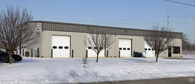
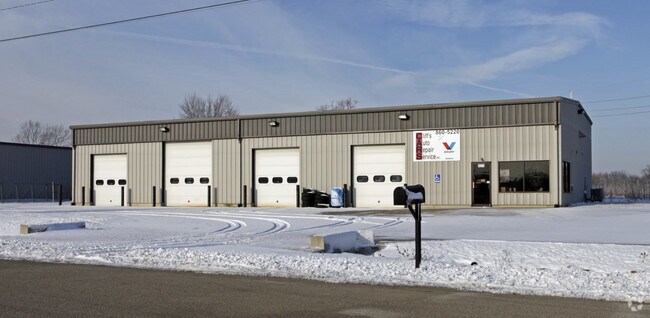
Property Record
1071 Tedia Way, Fairfield, OH 45014

NEARBY LISTINGS FOR SALE OR LEASE
Property Detail
1071 Tedia Way
Cincinnati, OH-KY-IN
Fairfield
A0700-004-000-096
13461 ENT SEE TIF PCL 096T - FF NORTHEAST- FAIRFIELD TIF
Autorepair
Butler
X
Ohio
39017C0307F
13461
2024
1.90 AC
2024
Butler County
010906
Cincinnati/Dayton
4,800 SF
DEMOGRAPHICS near 1071 Tedia Way
1 Mile
3 Mile
5 Mile
2024 Total Population
983
64,163
168,521
2029 Population
1,014
65,256
170,636
Pop Growth 2024-2029
+ 3.15%
+ 1.70%
+ 1.26%
Average Age
31
39
39
2024 Total Households
281
25,215
64,575
HH Growth 2024-2029
+ 2.85%
+ 1.74%
+ 1.38%
Median Household Inc
$30,560
$60,614
$68,300
Avg Household Size
3.10
2.50
2.50
2024 Avg HH Vehicles
1.00
2.00
2.00
Median Home Value
$50,000
$170,028
$186,187
Median Year Built
1976
1974
1976
Nearby Places
Map Layers
Map Styles
 Street
 Aerial
- Restaurants
- Banks
- Shops
- Fitness
- Groceries
PUBLIC TRANSPORTATION
AIRPORT
Cincinnati/Northern Kentucky International
DRIVE
WALK
Distance
Cincinnati/Northern Kentucky International
61 min
37.3 mi
Freight Ports
Port of Toledo
DRIVE
WALK
Distance
Port of Toledo
230 min
195.2 mi
Nearby Properties
Address
Land Use
TOTAL SIZE
Lot Size
Zoning
Address
Land Use
TOTAL SIZE
Lot Size
Zoning
1,602,242 SF
36.46 AC
Address
Land Use
TOTAL SIZE
Lot Size
Zoning
40,006 SF
17.23 AC
Address
Land Use
TOTAL SIZE
Lot Size
Zoning
38,880 SF
20.93 AC
Address
Land Use
TOTAL SIZE
Lot Size
Zoning
1,363,493 SF
75.28 AC
Address
Land Use
TOTAL SIZE
Lot Size
Zoning
14,559 SF
27.50 AC
Address
Land Use
TOTAL SIZE
Lot Size
Zoning
559,332 SF
29.30 AC
Address
Land Use
TOTAL SIZE
Lot Size
Zoning
706,768 SF
35.92 AC
Address
Land Use
TOTAL SIZE
Lot Size
Zoning
510,080 SF
60.87 AC
Address
Land Use
TOTAL SIZE
Lot Size
Zoning
18.77 AC
Address
Land Use
TOTAL SIZE
Lot Size
Zoning
39.89 AC
Address
Land Use
TOTAL SIZE
Lot Size
Zoning
283,527 SF
28.17 AC
Address
Land Use
TOTAL SIZE
Lot Size
Zoning
467,263 SF
27.27 AC
ADV
Address
Land Use
TOTAL SIZE
Lot Size
Zoning
54.77 AC
Address
Land Use
TOTAL SIZE
Lot Size
Zoning
567,230 SF
31.45 AC
Address
Land Use
TOTAL SIZE
Lot Size
Zoning
629,044 SF
35.83 AC
Address
Land Use
TOTAL SIZE
Lot Size
Zoning
28.47 AC
Address
Land Use
TOTAL SIZE
Lot Size
Zoning
317,472 SF
23.73 AC
Address
Land Use
TOTAL SIZE
Lot Size
Zoning
357,452 SF
26.77 AC
Address
Land Use
TOTAL SIZE
Lot Size
Zoning
279,161 SF
28.02 AC
Address
Land Use
TOTAL SIZE
Lot Size
Zoning
506,870 SF
22.20 AC
Address
Land Use
TOTAL SIZE
Lot Size
Zoning
287,433 SF
23.36 AC
Address
Land Use
TOTAL SIZE
Lot Size
Zoning
310,074 SF
21.65 AC
Address
Land Use
TOTAL SIZE
Lot Size
Zoning
374,160 SF
23.98 AC
Address
Land Use
TOTAL SIZE
Lot Size
Zoning
30.51 AC
Address
Land Use
TOTAL SIZE
Lot Size
Zoning
438,182 SF
28.80 AC
Address
Land Use
TOTAL SIZE
Lot Size
Zoning
50,753 SF
19.74 AC
Address
Land Use
TOTAL SIZE
Lot Size
Zoning
24.45 AC
Address
Land Use
TOTAL SIZE
Lot Size
Zoning
183,864 SF
25.85 AC
Address
Land Use
TOTAL SIZE
Lot Size
Zoning
215,969 SF
16.08 AC
ADV
Address
Land Use
TOTAL SIZE
Lot Size
Zoning
269,546 SF
17.02 AC
The World's #1 Commercial Real Estate Marketplace
Connect with us
© 2025 CoStar Group
The information above has been obtained from sources believed reliable. While we do not doubt its accuracy we have not verified it and make no guarantee, warranty or representation about it. It is your responsibility to independently confirm its accuracy and completeness. Any projections, opinions, assumptions, or estimates used are for example only and do not represent the current or future performance of the property. The value of this transaction to you depends on tax and other factors which should be evaluated by your tax, financial, and legal advisors. You and your advisors should conduct a careful, independent investigation of the property to determine to your satisfaction the suitability of the property for your needs.