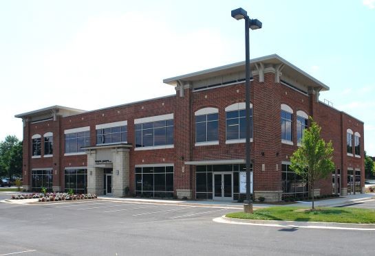
Property Record
10710 Medlock Bridge Rd, Duluth, GA 30097


NEARBY LISTINGS FOR SALE OR LEASE
Property Detail
10710 Medlock Bridge Rd
11-0910-0323-248-1
Parsons Mdw Professional Park
Officecondo
Fulton
X
Georgia
13121C0091G
0.13 AC
2024
N Fulton/Forsyth County
2025
Atlanta
011632
Atlanta-Sandy Springs-Roswell, GA
5,797 SF
DEMOGRAPHICS near 10710 Medlock Bridge Rd
1 Mile
3 Mile
5 Mile
2024 Total Population
10,099
71,719
184,864
2029 Population
10,235
73,945
193,373
Pop Growth 2024-2029
+ 1.35%
+ 3.10%
+ 4.60%
Average Age
40
40
39
2024 Total Households
3,514
24,552
63,130
HH Growth 2024-2029
+ 1.57%
+ 3.25%
+ 4.63%
Median Household Inc
$136,724
$135,076
$131,794
Avg Household Size
2.80
2.90
2.90
2024 Avg HH Vehicles
2.00
2.00
2.00
Median Home Value
$561,121
$466,565
$479,660
Median Year Built
1995
1994
1994
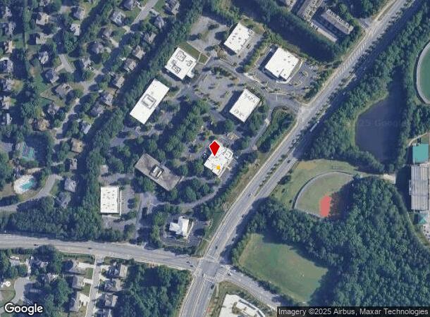
Nearby Places
Map Layers
Map Styles
 Street
 Aerial
- Restaurants
- Banks
- Shops
- Fitness
- Groceries
SALE & LEASE HISTORY
LISTING DATE
SALE/LEASE

Oct 10, 2017
For Sale
Oct 02, 2020
For Sale
May 17, 2019
For Sale
Jul 31, 2020
For Lease
Jan 04, 2021
For Lease
Aug 23, 2017
For Lease
Nearby Properties
Address
Land Use
TOTAL SIZE
Lot Size
Zoning
Address
Land Use
TOTAL SIZE
Lot Size
Zoning
321,541 SF
63.16 AC
OI
Address
Land Use
TOTAL SIZE
Lot Size
Zoning
2,044,910 SF
30.61 AC
CUP
Address
Land Use
TOTAL SIZE
Lot Size
Zoning
491,482 SF
41.72 AC
C1
Address
Land Use
TOTAL SIZE
Lot Size
Zoning
489,097 SF
34 AC
R3
Address
Land Use
TOTAL SIZE
Lot Size
Zoning
559,910 SF
74.65 AC
Address
Land Use
TOTAL SIZE
Lot Size
Zoning
341,506 SF
36.69 AC
C1
Address
Land Use
TOTAL SIZE
Lot Size
Zoning
299,952 SF
23.49 AC
MIAC
Address
Land Use
TOTAL SIZE
Lot Size
Zoning
237,995 SF
23 AC
TRC
Address
Land Use
TOTAL SIZE
Lot Size
Zoning
329,029 SF
21.16 AC
C1
Address
Land Use
TOTAL SIZE
Lot Size
Zoning
321,116 SF
17.06 AC
CBD
Address
Land Use
TOTAL SIZE
Lot Size
Zoning
1,351,350 SF
19.20 AC
OICON
Address
Land Use
TOTAL SIZE
Lot Size
Zoning
88.90 AC
AG1
Address
Land Use
TOTAL SIZE
Lot Size
Zoning
244,177 SF
8.96 AC
MIXU
Address
Land Use
TOTAL SIZE
Lot Size
Zoning
287,824 SF
31.59 AC
RM
Address
Land Use
TOTAL SIZE
Lot Size
Zoning
37.26 AC
TRC
Address
Land Use
TOTAL SIZE
Lot Size
Zoning
214,626 SF
6.29 AC
Address
Land Use
TOTAL SIZE
Lot Size
Zoning
629,088 SF
19.23 AC
CUP
Address
Land Use
TOTAL SIZE
Lot Size
Zoning
304,001 SF
32 AC
PUD
Address
Land Use
TOTAL SIZE
Lot Size
Zoning
1,650 SF
74.37 AC
AG1
Address
Land Use
TOTAL SIZE
Lot Size
Zoning
235,586 SF
16.21 AC
PUD
Address
Land Use
TOTAL SIZE
Lot Size
Zoning
289,676 SF
4.03 AC
C1
Address
Land Use
TOTAL SIZE
Lot Size
Zoning
180,572 SF
14.77 AC
C1
Address
Land Use
TOTAL SIZE
Lot Size
Zoning
212,250 SF
150 AC
AG1
Address
Land Use
TOTAL SIZE
Lot Size
Zoning
43.34 AC
R4A
Address
Land Use
TOTAL SIZE
Lot Size
Zoning
164,551 SF
21.10 AC
C1
Address
Land Use
TOTAL SIZE
Lot Size
Zoning
343,180 SF
17.29 AC
OI
Address
Land Use
TOTAL SIZE
Lot Size
Zoning
202,674 SF
8.42 AC
PUD
Address
Land Use
TOTAL SIZE
Lot Size
Zoning
163,592 SF
17.60 AC
OI
Address
Land Use
TOTAL SIZE
Lot Size
Zoning
1,845 SF
56.22 AC
AG1
Address
Land Use
TOTAL SIZE
Lot Size
Zoning
107,255 SF
6.12 AC
OI
The World's #1 Commercial Real Estate Marketplace
Connect with us
© 2025 CoStar Group
The information above has been obtained from sources believed reliable. While we do not doubt its accuracy we have not verified it and make no guarantee, warranty or representation about it. It is your responsibility to independently confirm its accuracy and completeness. Any projections, opinions, assumptions, or estimates used are for example only and do not represent the current or future performance of the property. The value of this transaction to you depends on tax and other factors which should be evaluated by your tax, financial, and legal advisors. You and your advisors should conduct a careful, independent investigation of the property to determine to your satisfaction the suitability of the property for your needs.