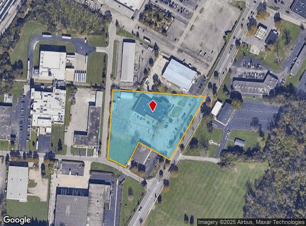
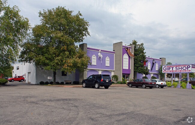
Property Record
10725 Reading Rd, Cincinnati, OH 45241

NEARBY LISTINGS FOR SALE OR LEASE
Property Detail
10725 Reading Rd
Cincinnati, OH-KY-IN
Graves 1St Sub
611-0030-0057
121.83X410.68 IR PT LT 14-15 P G GRAVES 1ST SUB OFEVENDALE RAIL SITE & ADJ TRACT P-57-153-154CN
Commercialnec
Hamilton
AE
Ohio
39061C0093E
14-15
2025
3.95 AC
2025
Tri-County I-275
023100
Cincinnati/Dayton
43,284 SF
DEMOGRAPHICS near 10725 Reading Rd
1 Mile
3 Mile
5 Mile
2024 Total Population
3,172
43,790
153,511
2029 Population
3,125
43,479
152,524
Pop Growth 2024-2029
(1.48%)
(0.71%)
(0.64%)
Average Age
43
41
41
2024 Total Households
1,357
18,307
63,234
HH Growth 2024-2029
(1.62%)
(0.90%)
(0.78%)
Median Household Inc
$109,813
$77,003
$78,686
Avg Household Size
2.30
2.30
2.30
2024 Avg HH Vehicles
2.00
2.00
2.00
Median Home Value
$227,059
$227,134
$235,095
Median Year Built
1969
1971
1967
Nearby Places
Map Layers
Map Styles
 Street
 Aerial
- Restaurants
- Banks
- Shops
- Fitness
- Groceries
PUBLIC TRANSPORTATION
AIRPORT
Cincinnati/Northern Kentucky International
DRIVE
WALK
Distance
Cincinnati/Northern Kentucky International
48 min
28.8 mi
Freight Ports
Port of Toledo
DRIVE
WALK
Distance
Port of Toledo
226 min
193.9 mi
Nearby Properties
Address
Land Use
TOTAL SIZE
Lot Size
Zoning
Address
Land Use
TOTAL SIZE
Lot Size
Zoning
47.52 AC
Address
Land Use
TOTAL SIZE
Lot Size
Zoning
6.03 AC
Address
Land Use
TOTAL SIZE
Lot Size
Zoning
119.08 AC
R1
Address
Land Use
TOTAL SIZE
Lot Size
Zoning
1,238 SF
14.03 AC
Address
Land Use
TOTAL SIZE
Lot Size
Zoning
15.33 AC
Address
Land Use
TOTAL SIZE
Lot Size
Zoning
29.79 AC
M1
Address
Land Use
TOTAL SIZE
Lot Size
Zoning
4,620 SF
85.80 AC
Address
Land Use
TOTAL SIZE
Lot Size
Zoning
Address
Land Use
TOTAL SIZE
Lot Size
Zoning
124.81 AC
Address
Land Use
TOTAL SIZE
Lot Size
Zoning
68.49 AC
Address
Land Use
TOTAL SIZE
Lot Size
Zoning
29.95 AC
Address
Land Use
TOTAL SIZE
Lot Size
Zoning
Address
Land Use
TOTAL SIZE
Lot Size
Zoning
Address
Land Use
TOTAL SIZE
Lot Size
Zoning
Address
Land Use
TOTAL SIZE
Lot Size
Zoning
4,599 SF
29.03 AC
R4
Address
Land Use
TOTAL SIZE
Lot Size
Zoning
8,964 SF
11.61 AC
Address
Land Use
TOTAL SIZE
Lot Size
Zoning
25,098 SF
21.31 AC
Address
Land Use
TOTAL SIZE
Lot Size
Zoning
555 SF
7.20 AC
M1
Address
Land Use
TOTAL SIZE
Lot Size
Zoning
5,085 SF
15.17 AC
Address
Land Use
TOTAL SIZE
Lot Size
Zoning
8.06 AC
Address
Land Use
TOTAL SIZE
Lot Size
Zoning
Address
Land Use
TOTAL SIZE
Lot Size
Zoning
Address
Land Use
TOTAL SIZE
Lot Size
Zoning
54.92 AC
Address
Land Use
TOTAL SIZE
Lot Size
Zoning
9,744 SF
8.15 AC
Address
Land Use
TOTAL SIZE
Lot Size
Zoning
Address
Land Use
TOTAL SIZE
Lot Size
Zoning
3,608 SF
8.05 AC
M1
Address
Land Use
TOTAL SIZE
Lot Size
Zoning
1,788 SF
9.55 AC
M1
Address
Land Use
TOTAL SIZE
Lot Size
Zoning
5.33 AC
Address
Land Use
TOTAL SIZE
Lot Size
Zoning
3,202 SF
3.34 AC
Address
Land Use
TOTAL SIZE
Lot Size
Zoning
17.10 AC
The World's #1 Commercial Real Estate Marketplace
Connect with us
© 2026 CoStar Group
The information above has been obtained from sources believed reliable. While we do not doubt its accuracy we have not verified it and make no guarantee, warranty or representation about it. It is your responsibility to independently confirm its accuracy and completeness. Any projections, opinions, assumptions, or estimates used are for example only and do not represent the current or future performance of the property. The value of this transaction to you depends on tax and other factors which should be evaluated by your tax, financial, and legal advisors. You and your advisors should conduct a careful, independent investigation of the property to determine to your satisfaction the suitability of the property for your needs.