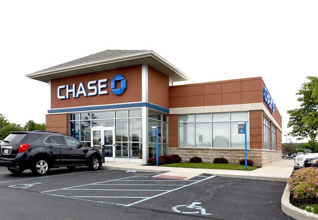
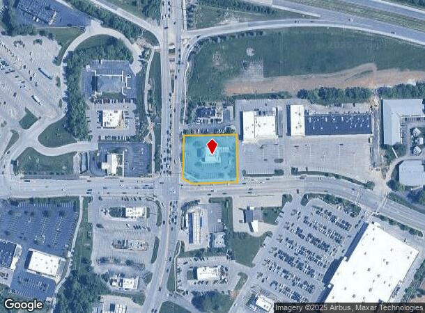
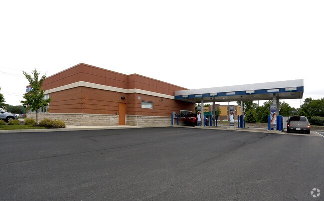
Property Record
1073 N Green St, Brownsburg, IN 46112
NEARBY LISTINGS FOR SALE OR LEASE
Property Detail
1073 N Green St
32-07-02-410-002.000-016
Brownsburg Tif Area
Financialbuilding
PT SE 2-16-1E 1.25 AC
X
Hendricks
18063C0157D
Indiana
2024
1.25 AC
2024
Hendricks County
210201
Indianapolis
4,132 SF
Indianapolis-Carmel-Anderson, IN
DEMOGRAPHICS near 1073 N Green St
1 Mile
3 Mile
5 Mile
2024 Total Population
8,917
38,835
70,699
2029 Population
10,002
43,381
78,499
Pop Growth 2024-2029
+ 12.17%
+ 11.71%
+ 11.03%
Average Age
37
39
39
2024 Total Households
3,508
14,072
25,612
HH Growth 2024-2029
+ 12.23%
+ 11.80%
+ 11.01%
Median Household Inc
$91,592
$110,913
$109,241
Avg Household Size
2.50
2.70
2.70
2024 Avg HH Vehicles
2.00
2.00
2.00
Median Home Value
$235,760
$254,077
$263,340
Median Year Built
1996
1998
1998
Nearby Places
Map Layers
Map Styles
 Street
 Aerial
- Restaurants
- Banks
- Shops
- Fitness
- Groceries
PUBLIC TRANSPORTATION
AIRPORT
Indianapolis International
DRIVE
WALK
Distance
Indianapolis International
28 min
15.6 mi
Freight Ports
Port of Toledo
DRIVE
WALK
Distance
Port of Toledo
285 min
233.7 mi
Nearby Properties
Address
Land Use
TOTAL SIZE
Lot Size
Zoning
Address
Land Use
TOTAL SIZE
Lot Size
Zoning
805,018 SF
48.20 AC
Address
Land Use
TOTAL SIZE
Lot Size
Zoning
683,528 SF
43.54 AC
Address
Land Use
TOTAL SIZE
Lot Size
Zoning
773,129 SF
36.12 AC
Address
Land Use
TOTAL SIZE
Lot Size
Zoning
Address
Land Use
TOTAL SIZE
Lot Size
Zoning
244,838 SF
3.01 AC
Address
Land Use
TOTAL SIZE
Lot Size
Zoning
32.50 AC
Address
Land Use
TOTAL SIZE
Lot Size
Zoning
225,712 SF
2.22 AC
Address
Land Use
TOTAL SIZE
Lot Size
Zoning
3,712 SF
17.58 AC
Address
Land Use
TOTAL SIZE
Lot Size
Zoning
54,586 SF
5.84 AC
Address
Land Use
TOTAL SIZE
Lot Size
Zoning
526,200 SF
28.31 AC
Address
Land Use
TOTAL SIZE
Lot Size
Zoning
405,824 SF
32.37 AC
Address
Land Use
TOTAL SIZE
Lot Size
Zoning
396,768 SF
20.88 AC
Address
Land Use
TOTAL SIZE
Lot Size
Zoning
86,706 SF
19.47 AC
Address
Land Use
TOTAL SIZE
Lot Size
Zoning
204,358 SF
12.50 AC
Address
Land Use
TOTAL SIZE
Lot Size
Zoning
20.46 AC
Address
Land Use
TOTAL SIZE
Lot Size
Zoning
28,228 SF
32.57 AC
Address
Land Use
TOTAL SIZE
Lot Size
Zoning
100,108 SF
50.12 AC
Address
Land Use
TOTAL SIZE
Lot Size
Zoning
80,046 SF
13.65 AC
Address
Land Use
TOTAL SIZE
Lot Size
Zoning
190,668 SF
14.97 AC
Address
Land Use
TOTAL SIZE
Lot Size
Zoning
99,038 SF
7.09 AC
Address
Land Use
TOTAL SIZE
Lot Size
Zoning
17,500 SF
33.72 AC
Address
Land Use
TOTAL SIZE
Lot Size
Zoning
Address
Land Use
TOTAL SIZE
Lot Size
Zoning
75,809 SF
7.91 AC
Address
Land Use
TOTAL SIZE
Lot Size
Zoning
5,934 SF
9.78 AC
Address
Land Use
TOTAL SIZE
Lot Size
Zoning
57,080 SF
2.04 AC
Address
Land Use
TOTAL SIZE
Lot Size
Zoning
15.70 AC
Address
Land Use
TOTAL SIZE
Lot Size
Zoning
67,480 SF
5 AC
Address
Land Use
TOTAL SIZE
Lot Size
Zoning
41,586 SF
10.30 AC
Address
Land Use
TOTAL SIZE
Lot Size
Zoning
122,044 SF
15.52 AC
Address
Land Use
TOTAL SIZE
Lot Size
Zoning
38,436 SF
7.99 AC
The World's #1 Commercial Real Estate Marketplace
Connect with us
© 2025 CoStar Group
The information above has been obtained from sources believed reliable. While we do not doubt its accuracy we have not verified it and make no guarantee, warranty or representation about it. It is your responsibility to independently confirm its accuracy and completeness. Any projections, opinions, assumptions, or estimates used are for example only and do not represent the current or future performance of the property. The value of this transaction to you depends on tax and other factors which should be evaluated by your tax, financial, and legal advisors. You and your advisors should conduct a careful, independent investigation of the property to determine to your satisfaction the suitability of the property for your needs.