Property Record
10734 Highway 36, Covington, GA 30014

Save to a Folder
{{folder.Name}}
{{folder.ListingIds.length}} Properties
{{folder.ListingIds.length}} Property
Create a New Folder
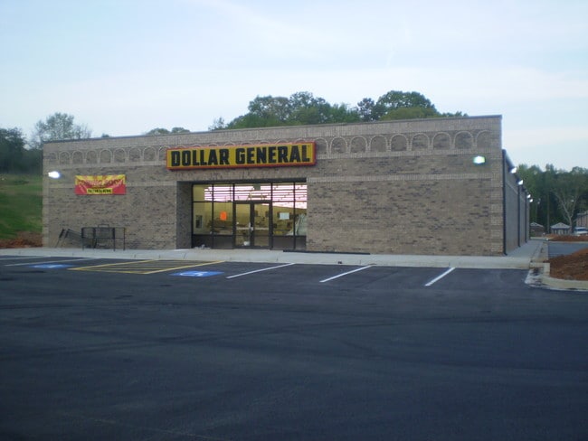
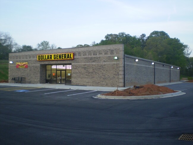
Property Detail
10734 Highway 36
C065000000010000
1.398AC HWY 36
Wholesaleoutletdiscountstore
NEWTON
C1
Georgia
B and X Area of moderate flood hazard, usually the area between the limits of the 100-year and 500-year floods.
0
2025
1.40 AC
2025
Lithonia/Conyers
100702
Atlanta
9,012 SF
Atlanta-Sandy Springs-Roswell, GA
NEARBY LISTINGS FOR SALE OR LEASE
DEMOGRAPHICS near 10734 Highway 36
1 mile
3 mile
5 mile
2025 Total Population
2,593
22,076
51,207
2030 Population
2,850
24,188
55,990
Pop Growth 2025-2030
+ 9.91%
+ 9.57%
+ 9.34%
Average Age
37
38
38
2025 Total Households
941
8,280
18,356
HH Growth 2025-2030
+ 10.10%
+ 9.69%
+ 9.47%
Median Household Inc
$68,869
$75,560
$73,450
Avg Household Size
2.70
2.60
2.70
2025 Avg HH Vehicles
2.00
2.00
2.00
Median Home Value
$235,074
$273,961
$264,910
Median Year Built
1994
1994
1996
Nearby Places
Map Layers
Map Styles
 Street
 Aerial
Layers
 Traffic
 Biking
Places
Listings with unknown addresses are not visible on the map
- Restaurants
- Banks
- Shops
- Fitness
- Groceries
PUBLIC TRANSPORTATION
AIRPORT
Hartsfield - Jackson Atlanta International
Drive
Walk
Distance
Hartsfield - Jackson Atlanta International
56 min
41.4 mi
SALE & LEASE HISTORY
LISTING DATE
SALE/LEASE

Jun 05, 2026
For Sale
Nearby Properties
Address
Land Use
TOTAL SIZE
Lot Size
Zoning
Address
Land Use
TOTAL SIZE
Lot Size
Zoning
258,254 SF
15.08 AC
C1
Address
Land Use
TOTAL SIZE
Lot Size
Zoning
6,664 SF
17.75 AC
Address
Land Use
TOTAL SIZE
Lot Size
Zoning
19,292 SF
8.20 AC
H1
Address
Land Use
TOTAL SIZE
Lot Size
Zoning
88,944 SF
0.98 AC
E1
Address
Land Use
TOTAL SIZE
Lot Size
Zoning
10,000 SF
0.01 AC
Address
Land Use
TOTAL SIZE
Lot Size
Zoning
1,627 SF
16.62 AC
C1
Address
Land Use
TOTAL SIZE
Lot Size
Zoning
14,080 SF
10 AC
C1
Address
Land Use
TOTAL SIZE
Lot Size
Zoning
28,790 SF
3.70 AC
E1
Address
Land Use
TOTAL SIZE
Lot Size
Zoning
159,034 SF
68.30 AC
E6
Address
Land Use
TOTAL SIZE
Lot Size
Zoning
31,376 SF
3.50 AC
PUD
Address
Land Use
TOTAL SIZE
Lot Size
Zoning
41,772 SF
28.03 AC
E6
Address
Land Use
TOTAL SIZE
Lot Size
Zoning
28,512 SF
0.52 AC
Address
Land Use
TOTAL SIZE
Lot Size
Zoning
69,487 SF
18.83 AC
C1
Address
Land Use
TOTAL SIZE
Lot Size
Zoning
27,492 SF
0.47 AC
Address
Land Use
TOTAL SIZE
Lot Size
Zoning
74,713 SF
2.83 AC
Address
Land Use
TOTAL SIZE
Lot Size
Zoning
101,010 SF
42.72 AC
E6
Address
Land Use
TOTAL SIZE
Lot Size
Zoning
61,638 SF
0.64 AC
Address
Land Use
TOTAL SIZE
Lot Size
Zoning
63,914 SF
7.04 AC
COMMERCIAL
Address
Land Use
TOTAL SIZE
Lot Size
Zoning
150,006 SF
8.89 AC
Address
Land Use
TOTAL SIZE
Lot Size
Zoning
25,100 SF
5.47 AC
Address
Land Use
TOTAL SIZE
Lot Size
Zoning
84,356 SF
10.12 AC
Address
Land Use
TOTAL SIZE
Lot Size
Zoning
61,534 SF
7.08 AC
C1
Address
Land Use
TOTAL SIZE
Lot Size
Zoning
12,812 SF
0.17 AC
E1
Address
Land Use
TOTAL SIZE
Lot Size
Zoning
44,330 SF
1.09 AC
E2
Address
Land Use
TOTAL SIZE
Lot Size
Zoning
65,360 SF
20 AC
E6
Address
Land Use
TOTAL SIZE
Lot Size
Zoning
21,060 SF
2.60 AC
C1
Address
Land Use
TOTAL SIZE
Lot Size
Zoning
18,447 SF
2.08 AC
R1
Address
Land Use
TOTAL SIZE
Lot Size
Zoning
47,074 SF
3.46 AC
PUD
Address
Land Use
TOTAL SIZE
Lot Size
Zoning
27,514 SF
16.55 AC
E1
Address
Land Use
TOTAL SIZE
Lot Size
Zoning
74,713 SF
0.01 AC
The World's #1 Commercial Real Estate Marketplace
Connect with us
© 2026 CoStar Group
The information above has been obtained from sources believed reliable. While we do not doubt its accuracy we have not verified it and make no guarantee, warranty or representation about it. It is your responsibility to independently confirm its accuracy and completeness. Any projections, opinions, assumptions, or estimates used are for example only and do not represent the current or future performance of the property. The value of this transaction to you depends on tax and other factors which should be evaluated by your tax, financial, and legal advisors. You and your advisors should conduct a careful, independent investigation of the property to determine to your satisfaction the suitability of the property for your needs.