Property Record
10735 Ravenna Rd, Twinsburg, OH 44087
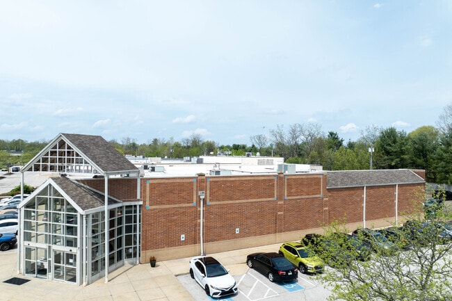
This Property Is For Sale
NEARBY LISTINGS FOR SALE OR LEASE
Property Detail
10735 Ravenna Rd
Akron, OH
01-N
64-03552
TR IN LOTS 9 10 E OF RAVENNA RD 470 FT FRT
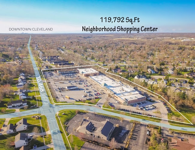
Regionalshoppingcenterormallwithanchorstore
Summit
X
Ohio
39153C0054F
9
2023
6.45 AC
2025
Akron
530104
Cleveland
77,323 SF
DEMOGRAPHICS near 10735 Ravenna Rd
1 Mile
3 Mile
5 Mile
2024 Total Population
5,690
38,298
88,436
2029 Population
5,587
37,584
86,734
Pop Growth 2024-2029
(1.81%)
(1.86%)
(1.92%)
Average Age
44
43
43
2024 Total Households
2,471
14,968
34,869
HH Growth 2024-2029
(1.74%)
(1.89%)
(1.99%)
Median Household Inc
$84,068
$97,732
$95,440
Avg Household Size
2.30
2.50
2.50
2024 Avg HH Vehicles
2.00
2.00
2.00
Median Home Value
$193,556
$277,983
$269,101
Median Year Built
1974
1987
1983
Nearby Places
Map Layers
Map Styles
 Street
 Aerial
- Restaurants
- Banks
- Shops
- Fitness
- Groceries
PUBLIC TRANSPORTATION
AIRPORT
Cleveland-Hopkins International
DRIVE
WALK
Distance
Cleveland-Hopkins International
34 min
26.9 mi
Akron-Canton Regional
DRIVE
WALK
Distance
Akron-Canton Regional
45 min
38.9 mi
Freight Ports
Port of Baltimore
DRIVE
WALK
Distance
Port of Baltimore
1 min
293.5 mi
Nearby Properties
Address
Land Use
TOTAL SIZE
Lot Size
Zoning
Address
Land Use
TOTAL SIZE
Lot Size
Zoning
Address
Land Use
TOTAL SIZE
Lot Size
Zoning
433,283 SF
29.89 AC
Address
Land Use
TOTAL SIZE
Lot Size
Zoning
315,935 SF
44.94 AC
Address
Land Use
TOTAL SIZE
Lot Size
Zoning
73,902 SF
12.85 AC
Address
Land Use
TOTAL SIZE
Lot Size
Zoning
433,283 SF
40.49 AC
Address
Land Use
TOTAL SIZE
Lot Size
Zoning
325,774 SF
57.80 AC
Address
Land Use
TOTAL SIZE
Lot Size
Zoning
475,568 SF
38.17 AC
IG
Address
Land Use
TOTAL SIZE
Lot Size
Zoning
Address
Land Use
TOTAL SIZE
Lot Size
Zoning
Address
Land Use
TOTAL SIZE
Lot Size
Zoning
300,563 SF
32.51 AC
Address
Land Use
TOTAL SIZE
Lot Size
Zoning
396,420 SF
26.02 AC
IG
Address
Land Use
TOTAL SIZE
Lot Size
Zoning
401,401 SF
25.14 AC
IG
Address
Land Use
TOTAL SIZE
Lot Size
Zoning
351,000 SF
25.48 AC
IG
Address
Land Use
TOTAL SIZE
Lot Size
Zoning
270,968 SF
21.68 AC
Address
Land Use
TOTAL SIZE
Lot Size
Zoning
458,000 SF
35.06 AC
IG
Address
Land Use
TOTAL SIZE
Lot Size
Zoning
254,828 SF
15.41 AC
Address
Land Use
TOTAL SIZE
Lot Size
Zoning
60,305 SF
57.84 AC
Address
Land Use
TOTAL SIZE
Lot Size
Zoning
342,068 SF
29.02 AC
Address
Land Use
TOTAL SIZE
Lot Size
Zoning
418,992 SF
27.87 AC
Address
Land Use
TOTAL SIZE
Lot Size
Zoning
262,950 SF
26.24 AC
IG
Address
Land Use
TOTAL SIZE
Lot Size
Zoning
290,113 SF
15.05 AC
Address
Land Use
TOTAL SIZE
Lot Size
Zoning
20.49 AC
R-1-C
Address
Land Use
TOTAL SIZE
Lot Size
Zoning
351,911 SF
39.85 AC
I-2
Address
Land Use
TOTAL SIZE
Lot Size
Zoning
Address
Land Use
TOTAL SIZE
Lot Size
Zoning
353,200 SF
25.60 AC
Address
Land Use
TOTAL SIZE
Lot Size
Zoning
111,145 SF
39.21 AC
Address
Land Use
TOTAL SIZE
Lot Size
Zoning
Address
Land Use
TOTAL SIZE
Lot Size
Zoning
197,930 SF
14.80 AC
I-2
Address
Land Use
TOTAL SIZE
Lot Size
Zoning
210,600 SF
12.69 AC
I-2
Address
Land Use
TOTAL SIZE
Lot Size
Zoning
300,900 SF
10.39 AC
The World's #1 Commercial Real Estate Marketplace
Connect with us
© 2025 CoStar Group
The information above has been obtained from sources believed reliable. While we do not doubt its accuracy we have not verified it and make no guarantee, warranty or representation about it. It is your responsibility to independently confirm its accuracy and completeness. Any projections, opinions, assumptions, or estimates used are for example only and do not represent the current or future performance of the property. The value of this transaction to you depends on tax and other factors which should be evaluated by your tax, financial, and legal advisors. You and your advisors should conduct a careful, independent investigation of the property to determine to your satisfaction the suitability of the property for your needs.