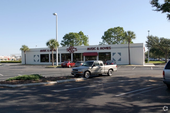
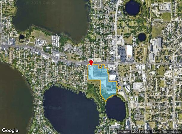
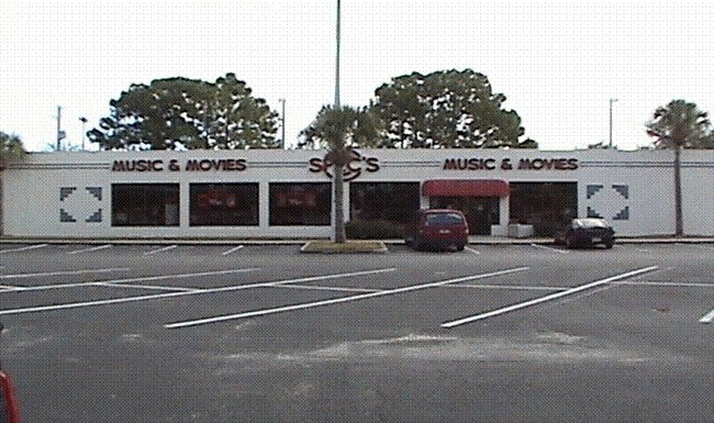
Property Record
1074 Havendale Blvd Nw, Winter Haven, FL 33881
NEARBY LISTINGS FOR SALE OR LEASE
Property Detail
1074 Havendale Blvd Nw
Lakeland-Winter Haven, FL
Lakeside Memorial Pk 2Nd Repla
26-28-17-000000-042010
EG 764.01 FT S & 580 FT E NW COR OF SE1/4 SW1/4 RUN E 390.05 FT S 65.97 FT E 371.02 FT TO E LINE SAID SE1/4 SW1/4 S 300.18 FT N-65 1406-E 156.73 FT N-19 1430-E 61.17 FT S-24 4554-E 156.5 FT N-71 0843-W 58.71 FT S-65 1406-W 50 FT S-72 3036-W 94.76
Regionalshoppingcenterormallwithanchorstore
Polk
AE
Florida
12105C0365G
5
2024
27.79 AC
2025
Polk County
013500
Tampa/St Petersburg
188,403 SF
DEMOGRAPHICS near 1074 Havendale Blvd Nw
1 Mile
3 Mile
5 Mile
2024 Total Population
7,027
56,174
113,447
2029 Population
8,471
67,636
136,740
Pop Growth 2024-2029
+ 20.55%
+ 20.40%
+ 20.53%
Average Age
44
40
41
2024 Total Households
3,045
22,145
44,140
HH Growth 2024-2029
+ 20.26%
+ 20.36%
+ 20.46%
Median Household Inc
$43,058
$45,376
$53,625
Avg Household Size
2.20
2.50
2.50
2024 Avg HH Vehicles
1.00
2.00
2.00
Median Home Value
$255,936
$176,703
$187,579
Median Year Built
1977
1976
1982
Nearby Places
Map Layers
Map Styles
 Street
 Aerial
- Restaurants
- Banks
- Shops
- Fitness
- Groceries
PUBLIC TRANSPORTATION
COMMUTER RAIL
DRIVE
WALK
Distance
7 min
3.2 mi
AIRPORT
Orlando International
DRIVE
WALK
Distance
Orlando International
62 min
45.7 mi
Freight Ports
Port of Tampa Bay
DRIVE
WALK
Distance
Port of Tampa Bay
69 min
47.9 mi
Nearby Properties
Address
Land Use
TOTAL SIZE
Lot Size
Zoning
Address
Land Use
TOTAL SIZE
Lot Size
Zoning
942,646 SF
91.30 AC
R3
Address
Land Use
TOTAL SIZE
Lot Size
Zoning
728,846 SF
28.07 AC
Address
Land Use
TOTAL SIZE
Lot Size
Zoning
250,170 SF
24.21 AC
Address
Land Use
TOTAL SIZE
Lot Size
Zoning
504,548 SF
26.82 AC
BR
Address
Land Use
TOTAL SIZE
Lot Size
Zoning
135,118 SF
7.26 AC
Address
Land Use
TOTAL SIZE
Lot Size
Zoning
282,400 SF
19.59 AC
XX
Address
Land Use
TOTAL SIZE
Lot Size
Zoning
267,076 SF
31.67 AC
Address
Land Use
TOTAL SIZE
Lot Size
Zoning
85,378 SF
4.20 AC
BR
Address
Land Use
TOTAL SIZE
Lot Size
Zoning
75,936 SF
0.76 AC
R3
Address
Land Use
TOTAL SIZE
Lot Size
Zoning
155,373 SF
72.76 AC
Address
Land Use
TOTAL SIZE
Lot Size
Zoning
200,200 SF
10.29 AC
Address
Land Use
TOTAL SIZE
Lot Size
Zoning
503,625 SF
20.61 AC
Address
Land Use
TOTAL SIZE
Lot Size
Zoning
225,126 SF
24.54 AC
Address
Land Use
TOTAL SIZE
Lot Size
Zoning
148,390 SF
10.42 AC
R1
Address
Land Use
TOTAL SIZE
Lot Size
Zoning
277,680 SF
43.76 AC
R1C
Address
Land Use
TOTAL SIZE
Lot Size
Zoning
123,540 SF
5.89 AC
Address
Land Use
TOTAL SIZE
Lot Size
Zoning
259,700 SF
51.97 AC
Address
Land Use
TOTAL SIZE
Lot Size
Zoning
135,885 SF
10.12 AC
Address
Land Use
TOTAL SIZE
Lot Size
Zoning
102,307 SF
1.79 AC
RP
Address
Land Use
TOTAL SIZE
Lot Size
Zoning
77,388 SF
5.37 AC
BT
Address
Land Use
TOTAL SIZE
Lot Size
Zoning
185,895 SF
16.16 AC
BR
Address
Land Use
TOTAL SIZE
Lot Size
Zoning
173,328 SF
37.45 AC
C3
Address
Land Use
TOTAL SIZE
Lot Size
Zoning
129,567 SF
11.72 AC
C3
Address
Land Use
TOTAL SIZE
Lot Size
Zoning
277,729 SF
423.34 AC
Address
Land Use
TOTAL SIZE
Lot Size
Zoning
70,900 SF
1.62 AC
Address
Land Use
TOTAL SIZE
Lot Size
Zoning
90,200 SF
1.93 AC
RP
Address
Land Use
TOTAL SIZE
Lot Size
Zoning
122,752 SF
1.68 AC
Address
Land Use
TOTAL SIZE
Lot Size
Zoning
76,664 SF
18.64 AC
RP
Address
Land Use
TOTAL SIZE
Lot Size
Zoning
106,524 SF
11.32 AC
The World's #1 Commercial Real Estate Marketplace
Connect with us
© 2026 CoStar Group
The information above has been obtained from sources believed reliable. While we do not doubt its accuracy we have not verified it and make no guarantee, warranty or representation about it. It is your responsibility to independently confirm its accuracy and completeness. Any projections, opinions, assumptions, or estimates used are for example only and do not represent the current or future performance of the property. The value of this transaction to you depends on tax and other factors which should be evaluated by your tax, financial, and legal advisors. You and your advisors should conduct a careful, independent investigation of the property to determine to your satisfaction the suitability of the property for your needs.