Property Record
10740 4Th St, Rancho Cucamonga, CA 91730
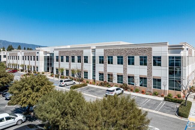
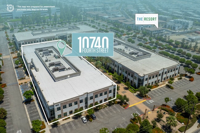

This Property Is For Sale
NEARBY LISTINGS FOR SALE OR LEASE
Property Detail
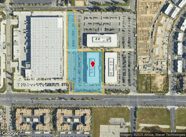
10740 4Th St
0210-082-88
PARCEL 3 OF PARCEL MAP 17318 IN THE CITY OF RANCHO CUCAMONGA, COUNTY OF SAN BERNARDINO STATE OF CALIFORNIA AS PER MAP BOOK 214 PAGES 83 AND 84 IN THE OFFICE OF THE COUNTY RECORDER OF SAID COUNTY TOGETHER WITH THOSE PORTIONS OF PARCELS OF SAID PARCEL
Officebuilding
San Bernardino
X
California
06071C8629H
4.78 AC
2025
Airport Area
2025
Inland Empire (California)
002112
Riverside-San Bernardino-Ontario, CA
84,604 SF
DEMOGRAPHICS near 10740 4Th St
1 mile
3 mile
5 mile
2024 Total Population
9,886
81,020
296,356
2029 Population
10,200
82,449
301,010
Pop Growth 2024-2029
+ 3.18%
+ 1.76%
+ 1.57%
Average Age
34
36
37
2024 Total Households
4,396
27,789
94,553
HH Growth 2024-2029
+ 3.48%
+ 1.90%
+ 1.65%
Median Household Inc
$75,104
$84,289
$87,945
Avg Household Size
2.20
2.80
3.00
2024 Avg HH Vehicles
2.00
2.00
2.00
Median Home Value
$456,474
$487,081
$565,483
Median Year Built
2003
1988
1984
Nearby Places
Map Layers
Map Styles
 Street
 Aerial
Transit
 Traffic
 Biking
Places
Listings with unknown addresses are not visible on the map
- Restaurants
- Banks
- Shops
- Fitness
- Groceries
PUBLIC TRANSPORTATION
COMMUTER RAIL
Rancho Cucamonga (San Bernardino Line - Southern California Regional Rail Authority (Metrolink))
Drive
Walk
Distance
Rancho Cucamonga (San Bernardino Line - Southern California Regional Rail Authority (Metrolink))
5 min
2.1 mi
East Ontario (Riverside Line - Southern California Regional Rail Authority (Metrolink))
Drive
Walk
Distance
East Ontario (Riverside Line - Southern California Regional Rail Authority (Metrolink))
7 min
3.4 mi
AIRPORT
Ontario International
Drive
Walk
Distance
Ontario International
7 min
3.3 mi
John Wayne/Orange County
Drive
Walk
Distance
John Wayne/Orange County
55 min
44.0 mi
Nearby Properties
Address
Land Use
TOTAL SIZE
Lot Size
Zoning
Address
Land Use
TOTAL SIZE
Lot Size
Zoning
1,459,702 SF
96.41 AC
Address
Land Use
TOTAL SIZE
Lot Size
Zoning
1,422,524 SF
44.96 AC
Address
Land Use
TOTAL SIZE
Lot Size
Zoning
244,370 SF
59.72 AC
Address
Land Use
TOTAL SIZE
Lot Size
Zoning
1,613,290 SF
59.42 AC
Address
Land Use
TOTAL SIZE
Lot Size
Zoning
707,551 SF
20.36 AC
Address
Land Use
TOTAL SIZE
Lot Size
Zoning
752,497 SF
24.89 AC
Address
Land Use
TOTAL SIZE
Lot Size
Zoning
539,128 SF
10.24 AC
Address
Land Use
TOTAL SIZE
Lot Size
Zoning
1,385,866 SF
69.84 AC
Address
Land Use
TOTAL SIZE
Lot Size
Zoning
459,431 SF
23.10 AC
Address
Land Use
TOTAL SIZE
Lot Size
Zoning
275,783 SF
11.82 AC
Address
Land Use
TOTAL SIZE
Lot Size
Zoning
261,114 SF
11.23 AC
Address
Land Use
TOTAL SIZE
Lot Size
Zoning
293,860 SF
16.10 AC
Address
Land Use
TOTAL SIZE
Lot Size
Zoning
34.80 AC
Address
Land Use
TOTAL SIZE
Lot Size
Zoning
145,111 SF
48.01 AC
Address
Land Use
TOTAL SIZE
Lot Size
Zoning
545,161 SF
11.10 AC
Address
Land Use
TOTAL SIZE
Lot Size
Zoning
453,960 SF
18.54 AC
Address
Land Use
TOTAL SIZE
Lot Size
Zoning
591,495 SF
18.29 AC
Address
Land Use
TOTAL SIZE
Lot Size
Zoning
104,537 SF
30.72 AC
Address
Land Use
TOTAL SIZE
Lot Size
Zoning
1,052,840 SF
41.85 AC
Address
Land Use
TOTAL SIZE
Lot Size
Zoning
531,988 SF
9.83 AC
Address
Land Use
TOTAL SIZE
Lot Size
Zoning
611,573 SF
26.64 AC
Address
Land Use
TOTAL SIZE
Lot Size
Zoning
87,909 SF
30.12 AC
Address
Land Use
TOTAL SIZE
Lot Size
Zoning
286,732 SF
9.58 AC
Address
Land Use
TOTAL SIZE
Lot Size
Zoning
261,357 SF
10.03 AC
Address
Land Use
TOTAL SIZE
Lot Size
Zoning
440,209 SF
10.34 AC
Address
Land Use
TOTAL SIZE
Lot Size
Zoning
447,119 SF
17.34 AC
Address
Land Use
TOTAL SIZE
Lot Size
Zoning
830,300 SF
39.99 AC
Address
Land Use
TOTAL SIZE
Lot Size
Zoning
317,070 SF
14.26 AC
Address
Land Use
TOTAL SIZE
Lot Size
Zoning
190,724 SF
10.69 AC
Address
Land Use
TOTAL SIZE
Lot Size
Zoning
849,900 SF
39.25 AC
KCSP
The World's #1 Commercial Real Estate Marketplace
Connect with us
© 2026 CoStar Group
The information above has been obtained from sources believed reliable. While we do not doubt its accuracy we have not verified it and make no guarantee, warranty or representation about it. It is your responsibility to independently confirm its accuracy and completeness. Any projections, opinions, assumptions, or estimates used are for example only and do not represent the current or future performance of the property. The value of this transaction to you depends on tax and other factors which should be evaluated by your tax, financial, and legal advisors. You and your advisors should conduct a careful, independent investigation of the property to determine to your satisfaction the suitability of the property for your needs.