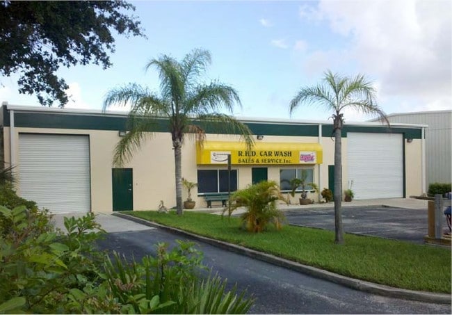
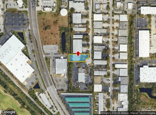
Property Record
10740 76Th Ct, Seminole, FL 33777

NEARBY LISTINGS FOR SALE OR LEASE
Property Detail
10740 76Th Ct
Tampa-St. Petersburg-Clearwater, FL
Suncoast Business Park
18-30-16-86375-000-0080
SUNCOAST BUSINESS PARK LOT 8
Lightindustrial
Pinellas
X
Florida
12103C0201J
8
2024
0.58 AC
2025
Mid-Pinellas
025009
Tampa/St Petersburg
7,700 SF
DEMOGRAPHICS near 10740 76Th Ct
1 Mile
3 Mile
5 Mile
2024 Total Population
5,742
96,194
256,075
2029 Population
5,767
96,299
256,680
Pop Growth 2024-2029
+ 0.44%
+ 0.11%
+ 0.24%
Average Age
45
46
46
2024 Total Households
2,501
42,300
116,158
HH Growth 2024-2029
+ 0.20%
0.00%
+ 0.15%
Median Household Inc
$76,460
$59,122
$56,878
Avg Household Size
2.20
2.20
2.10
2024 Avg HH Vehicles
2.00
2.00
2.00
Median Home Value
$319,718
$212,695
$229,021
Median Year Built
1980
1978
1975
Nearby Places
Map Layers
Map Styles
 Street
 Aerial
- Restaurants
- Banks
- Shops
- Fitness
- Groceries
PUBLIC TRANSPORTATION
AIRPORT
St Pete-Clearwater International
DRIVE
WALK
Distance
St Pete-Clearwater International
12 min
5.9 mi
Tampa International
DRIVE
WALK
Distance
Tampa International
29 min
18.5 mi
Sarasota/Bradenton International
DRIVE
WALK
Distance
Sarasota/Bradenton International
64 min
43.1 mi
Freight Ports
Port of Tampa Bay
DRIVE
WALK
Distance
Port of Tampa Bay
39 min
23.9 mi
Nearby Properties
Address
Land Use
TOTAL SIZE
Lot Size
Zoning
Address
Land Use
TOTAL SIZE
Lot Size
Zoning
459,848 SF
19.74 AC
R6
Address
Land Use
TOTAL SIZE
Lot Size
Zoning
372,013 SF
10.10 AC
Address
Land Use
TOTAL SIZE
Lot Size
Zoning
382,389 SF
13.62 AC
Address
Land Use
TOTAL SIZE
Lot Size
Zoning
333,425 SF
33.66 AC
Address
Land Use
TOTAL SIZE
Lot Size
Zoning
402,681 SF
18.40 AC
Address
Land Use
TOTAL SIZE
Lot Size
Zoning
384,124 SF
25.78 AC
C3
Address
Land Use
TOTAL SIZE
Lot Size
Zoning
362,618 SF
40.19 AC
R6
Address
Land Use
TOTAL SIZE
Lot Size
Zoning
266,396 SF
23.18 AC
Address
Land Use
TOTAL SIZE
Lot Size
Zoning
227,858 SF
64.31 AC
AE
Address
Land Use
TOTAL SIZE
Lot Size
Zoning
294,478 SF
44.79 AC
M1
Address
Land Use
TOTAL SIZE
Lot Size
Zoning
206,685 SF
16.75 AC
RPD5
Address
Land Use
TOTAL SIZE
Lot Size
Zoning
267,649 SF
17.86 AC
Address
Land Use
TOTAL SIZE
Lot Size
Zoning
582,271 SF
17.14 AC
Address
Land Use
TOTAL SIZE
Lot Size
Zoning
249,699 SF
15 AC
Address
Land Use
TOTAL SIZE
Lot Size
Zoning
10,474 SF
660.47 AC
R3
Address
Land Use
TOTAL SIZE
Lot Size
Zoning
280,129 SF
Address
Land Use
TOTAL SIZE
Lot Size
Zoning
261,486 SF
30.21 AC
RPD20
Address
Land Use
TOTAL SIZE
Lot Size
Zoning
194,610 SF
36.55 AC
R3
Address
Land Use
TOTAL SIZE
Lot Size
Zoning
174,082 SF
17.08 AC
C2
Address
Land Use
TOTAL SIZE
Lot Size
Zoning
211,684 SF
14.48 AC
M1
Address
Land Use
TOTAL SIZE
Lot Size
Zoning
194,748 SF
12.69 AC
M1
Address
Land Use
TOTAL SIZE
Lot Size
Zoning
127,392 SF
12.11 AC
Address
Land Use
TOTAL SIZE
Lot Size
Zoning
687,675 SF
67.89 AC
M1
Address
Land Use
TOTAL SIZE
Lot Size
Zoning
159,667 SF
20 AC
AE
Address
Land Use
TOTAL SIZE
Lot Size
Zoning
297,508 SF
36.80 AC
Address
Land Use
TOTAL SIZE
Lot Size
Zoning
196,000 SF
13.06 AC
Address
Land Use
TOTAL SIZE
Lot Size
Zoning
116,358 SF
12.74 AC
Address
Land Use
TOTAL SIZE
Lot Size
Zoning
160,328 SF
8.15 AC
Address
Land Use
TOTAL SIZE
Lot Size
Zoning
133,440 SF
12.67 AC
R4
Address
Land Use
TOTAL SIZE
Lot Size
Zoning
145,660 SF
16.22 AC
R3
The World's #1 Commercial Real Estate Marketplace
Connect with us
© 2025 CoStar Group
The information above has been obtained from sources believed reliable. While we do not doubt its accuracy we have not verified it and make no guarantee, warranty or representation about it. It is your responsibility to independently confirm its accuracy and completeness. Any projections, opinions, assumptions, or estimates used are for example only and do not represent the current or future performance of the property. The value of this transaction to you depends on tax and other factors which should be evaluated by your tax, financial, and legal advisors. You and your advisors should conduct a careful, independent investigation of the property to determine to your satisfaction the suitability of the property for your needs.