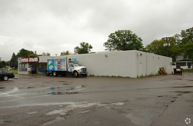
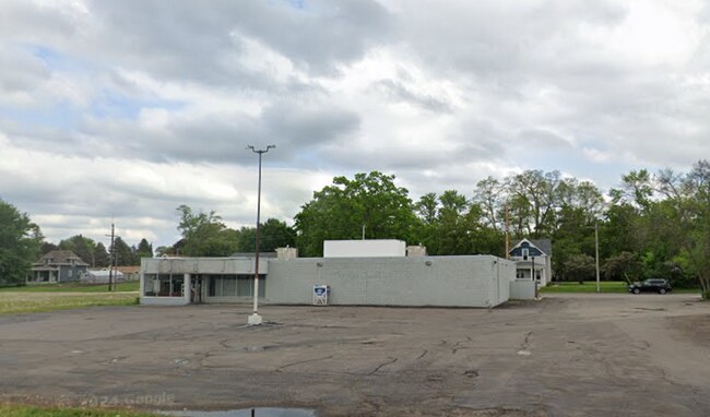
Property Record
10740 Railroad Ave, Chisago City, MN 55013

NEARBY LISTINGS FOR SALE OR LEASE
-
-
View all Chisago City listings for lease on LoopNet.com
Property Detail
10740 Railroad Ave
13-00026-10
PT OF GOV'T LOT 4 DES AS FOL: BG AT THE INTERSECTION OF E LINE OF BENNET AVE. & N LINE OF RAILROAD AVE; TH E'LY ON N LINE OF
Commercialnec
Chisago
X
Minnesota
27025C0360D
0.71 AC
2025
Chisago County
2024
Minneapolis/St Paul
110503
Minneapolis-St. Paul-Bloomington, MN-WI
8,128 SF
DEMOGRAPHICS near 10740 Railroad Ave
1 Mile
3 Mile
5 Mile
2024 Total Population
2,244
11,295
17,787
2029 Population
2,377
11,990
18,833
Pop Growth 2024-2029
+ 5.93%
+ 6.15%
+ 5.88%
Average Age
46
43
42
2024 Total Households
976
4,481
6,895
HH Growth 2024-2029
+ 5.94%
+ 6.20%
+ 5.99%
Median Household Inc
$78,080
$96,788
$97,964
Avg Household Size
2.20
2.50
2.50
2024 Avg HH Vehicles
2.00
2.00
2.00
Median Home Value
$327,419
$325,899
$324,848
Median Year Built
1981
1990
1990
Nearby Places
Map Layers
Map Styles
 Street
 Aerial
- Restaurants
- Banks
- Shops
- Fitness
- Groceries
SALE & LEASE HISTORY
LISTING DATE
SALE/LEASE

Nov 25, 2024
For Lease
Nearby Properties
Address
Land Use
TOTAL SIZE
Lot Size
Zoning
Address
Land Use
TOTAL SIZE
Lot Size
Zoning
325,279 SF
46.50 AC
RR1
Address
Land Use
TOTAL SIZE
Lot Size
Zoning
116,494 SF
59.91 AC
Address
Land Use
TOTAL SIZE
Lot Size
Zoning
116,816 SF
3.39 AC
Address
Land Use
TOTAL SIZE
Lot Size
Zoning
35,200 SF
13.30 AC
R3
Address
Land Use
TOTAL SIZE
Lot Size
Zoning
77,394 SF
8.94 AC
R1
Address
Land Use
TOTAL SIZE
Lot Size
Zoning
72,581 SF
24.54 AC
R3
Address
Land Use
TOTAL SIZE
Lot Size
Zoning
102,458 SF
3.35 AC
LI
Address
Land Use
TOTAL SIZE
Lot Size
Zoning
61,322 SF
16.61 AC
PSPF
Address
Land Use
TOTAL SIZE
Lot Size
Zoning
57,109 SF
11 AC
R1A
Address
Land Use
TOTAL SIZE
Lot Size
Zoning
50,098 SF
3.56 AC
R3
Address
Land Use
TOTAL SIZE
Lot Size
Zoning
62,497 SF
12 AC
PSPF
Address
Land Use
TOTAL SIZE
Lot Size
Zoning
9,059 SF
3.43 AC
R1
Address
Land Use
TOTAL SIZE
Lot Size
Zoning
15,931 SF
1.70 AC
I1
Address
Land Use
TOTAL SIZE
Lot Size
Zoning
63,974 SF
6.89 AC
I1
Address
Land Use
TOTAL SIZE
Lot Size
Zoning
17,783 SF
1.89 AC
Address
Land Use
TOTAL SIZE
Lot Size
Zoning
32,877 SF
1.31 AC
Address
Land Use
TOTAL SIZE
Lot Size
Zoning
26,480 SF
24.80 AC
PSPF
Address
Land Use
TOTAL SIZE
Lot Size
Zoning
22,147 SF
3.21 AC
B2
Address
Land Use
TOTAL SIZE
Lot Size
Zoning
56,994 SF
5 AC
Address
Land Use
TOTAL SIZE
Lot Size
Zoning
23,313 SF
3.20 AC
R3
Address
Land Use
TOTAL SIZE
Lot Size
Zoning
30,840 SF
0.15 AC
R3
Address
Land Use
TOTAL SIZE
Lot Size
Zoning
24,533 SF
1 AC
R3
Address
Land Use
TOTAL SIZE
Lot Size
Zoning
26,519 SF
2.79 AC
PSPF
Address
Land Use
TOTAL SIZE
Lot Size
Zoning
33,350 SF
4.20 AC
R1
Address
Land Use
TOTAL SIZE
Lot Size
Zoning
1.35 AC
Address
Land Use
TOTAL SIZE
Lot Size
Zoning
1,200 SF
49.90 AC
PSPOS
Address
Land Use
TOTAL SIZE
Lot Size
Zoning
10,460 SF
2.20 AC
C
Address
Land Use
TOTAL SIZE
Lot Size
Zoning
12,463 SF
0.54 AC
CBD
Address
Land Use
TOTAL SIZE
Lot Size
Zoning
12,284 SF
3.08 AC
RR1
The World's #1 Commercial Real Estate Marketplace
Connect with us
© 2026 CoStar Group
The information above has been obtained from sources believed reliable. While we do not doubt its accuracy we have not verified it and make no guarantee, warranty or representation about it. It is your responsibility to independently confirm its accuracy and completeness. Any projections, opinions, assumptions, or estimates used are for example only and do not represent the current or future performance of the property. The value of this transaction to you depends on tax and other factors which should be evaluated by your tax, financial, and legal advisors. You and your advisors should conduct a careful, independent investigation of the property to determine to your satisfaction the suitability of the property for your needs.