Property Record
10747 Airport Rd, Columbia, CA 95310
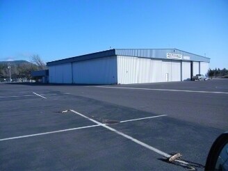


Property Detail
10747 Airport Rd
032-320-012-000
POR SECS 10 11 14 15 T2N R14E (AIRPORT) 343.48AC
Countyproperty
TUOLUMNE
BP,D
California
B and X Area of moderate flood hazard, usually the area between the limits of the 100-year and 500-year floods.
343.48 AC
0
Merced/Central
2025
Other Market Areas
002101
Sonora, CA
NEARBY LISTINGS FOR SALE OR LEASE
-
-
View all Columbia listings for lease on LoopNet.com
DEMOGRAPHICS near 10747 Airport Rd
1 mile
3 mile
5 mile
2025 Total Population
1,609
6,400
15,538
2030 Population
1,559
6,092
14,820
Pop Growth 2025-2030
(3.11%)
(4.81%)
(4.62%)
Average Age
43
45
46
2025 Total Households
698
2,731
6,826
HH Growth 2025-2030
(3.44%)
(5.24%)
(5.04%)
Median Household Inc
$58,312
$81,348
$80,784
Avg Household Size
2.20
2.30
2.20
2025 Avg HH Vehicles
2.00
2.00
2.00
Median Home Value
$368,918
$442,133
$451,699
Median Year Built
1983
1978
1978
Nearby Places
Map Layers
Map Styles
 Street
 Aerial
Layers
 Traffic
 Biking
Places
Listings with unknown addresses are not visible on the map
- Restaurants
- Banks
- Shops
- Fitness
- Groceries
SALE & LEASE HISTORY
LISTING DATE
SALE/LEASE

Oct 26, 2016
For Lease
Oct 26, 2016
For Sale
Nearby Properties
Address
Land Use
TOTAL SIZE
Lot Size
Zoning
Address
Land Use
TOTAL SIZE
Lot Size
Zoning
168 SF
117.44 AC
AE-37
Address
Land Use
TOTAL SIZE
Lot Size
Zoning
106,879 SF
8.10 AC
R-3,D,MX
Address
Land Use
TOTAL SIZE
Lot Size
Zoning
2,498 SF
0.75 AC
PD
Address
Land Use
TOTAL SIZE
Lot Size
Zoning
9,100 SF
0.80 AC
Address
Land Use
TOTAL SIZE
Lot Size
Zoning
600 SF
3.18 AC
C-1,AIR
Address
Land Use
TOTAL SIZE
Lot Size
Zoning
4,522 SF
2.32 AC
C-1,D,MX
Address
Land Use
TOTAL SIZE
Lot Size
Zoning
1.09 AC
R-2
Address
Land Use
TOTAL SIZE
Lot Size
Zoning
21,800 SF
1.74 AC
C-1,D,PD
Address
Land Use
TOTAL SIZE
Lot Size
Zoning
8,824 SF
0.80 AC
C-O,D,AIR
Address
Land Use
TOTAL SIZE
Lot Size
Zoning
2.71 AC
R-2,AIR
Address
Land Use
TOTAL SIZE
Lot Size
Zoning
7,020 SF
0.68 AC
R-1,D,H,MX
Address
Land Use
TOTAL SIZE
Lot Size
Zoning
5,505 SF
160.33 AC
AE-37,MX
Address
Land Use
TOTAL SIZE
Lot Size
Zoning
4,432 SF
82.64 AC
RE-5,MX
Address
Land Use
TOTAL SIZE
Lot Size
Zoning
1,510 SF
0.72 AC
C-1,D,PD
Address
Land Use
TOTAL SIZE
Lot Size
Zoning
12,966 SF
0.66 AC
C
Address
Land Use
TOTAL SIZE
Lot Size
Zoning
10,672 SF
1.56 AC
PD
Address
Land Use
TOTAL SIZE
Lot Size
Zoning
4,479 SF
18.26 AC
A-20,MX
Address
Land Use
TOTAL SIZE
Lot Size
Zoning
6,178 SF
5.68 AC
RE-5,AIR
Address
Land Use
TOTAL SIZE
Lot Size
Zoning
2.94 AC
R-3,D,AIR
Address
Land Use
TOTAL SIZE
Lot Size
Zoning
14.47 AC
M-U,PD,MX
Address
Land Use
TOTAL SIZE
Lot Size
Zoning
2,822 SF
46.34 AC
RE-10 & O
Address
Land Use
TOTAL SIZE
Lot Size
Zoning
2.87 AC
R-2
Address
Land Use
TOTAL SIZE
Lot Size
Zoning
2,924 SF
4.42 AC
Address
Land Use
TOTAL SIZE
Lot Size
Zoning
4,157 SF
16.73 AC
A-10,AIR
Address
Land Use
TOTAL SIZE
Lot Size
Zoning
1,404 SF
0.46 AC
R-1,R-2
Address
Land Use
TOTAL SIZE
Lot Size
Zoning
3.37 AC
C-1,D,AIR
Address
Land Use
TOTAL SIZE
Lot Size
Zoning
1,916 SF
6.52 AC
RE-5,AIR
Address
Land Use
TOTAL SIZE
Lot Size
Zoning
1,632 SF
1.64 AC
M-U,D,AIR
Address
Land Use
TOTAL SIZE
Lot Size
Zoning
2,897 SF
15.86 AC
A-10
The World's #1 Commercial Real Estate Marketplace
Connect with us
© 2026 CoStar Group
The information above has been obtained from sources believed reliable. While we do not doubt its accuracy we have not verified it and make no guarantee, warranty or representation about it. It is your responsibility to independently confirm its accuracy and completeness. Any projections, opinions, assumptions, or estimates used are for example only and do not represent the current or future performance of the property. The value of this transaction to you depends on tax and other factors which should be evaluated by your tax, financial, and legal advisors. You and your advisors should conduct a careful, independent investigation of the property to determine to your satisfaction the suitability of the property for your needs.