Property Record
1075 Edison Ave, Bronx, NY 10465
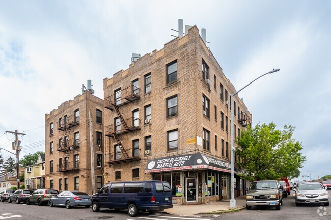

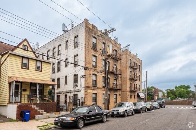
Property Detail
1075 Edison Ave
05419-0127
Bronx
Apartment
New York
R3A
127
B and X Area of moderate flood hazard, usually the area between the limits of the 100-year and 500-year floods.
0.17 AC
2024
Throgs Neck-Edgewater Park
2025
Westchester/So Connecticut
016400
New York-Jersey City-White Plains, NY-NJ
27,000 SF
NEARBY LISTINGS FOR SALE OR LEASE
DEMOGRAPHICS near 1075 Edison Ave
1 mile
3 mile
5 mile
2025 Total Population
35,709
384,086
1,370,526
2030 Population
32,926
365,345
1,334,306
Pop Growth 2025-2030
(7.79%)
(4.88%)
(2.64%)
Average Age
42
40
39
2025 Total Households
13,216
137,753
476,161
HH Growth 2025-2030
(8.47%)
(5.26%)
(3.11%)
Median Household Inc
$68,817
$57,274
$49,988
Avg Household Size
2.60
2.70
2.70
2025 Avg HH Vehicles
1.00
1.00
1.00
Median Home Value
$716,305
$604,632
$607,692
Median Year Built
1955
1955
1954
Nearby Places
Map Layers
Map Styles
 Street
 Aerial
Transit
 Traffic
 Biking
Places
Listings with unknown addresses are not visible on the map
- Restaurants
- Banks
- Shops
- Fitness
- Groceries
PUBLIC TRANSPORTATION
TRANSIT/SUBWAY
Buhre Avenue (6 - New York MTA Subway (The Subway))
Drive
Walk
Distance
Buhre Avenue (6 - New York MTA Subway (The Subway))
2 min
20 min
1.0 mi
Middletown Road (6 - New York MTA Subway (The Subway))
Drive
Walk
Distance
Middletown Road (6 - New York MTA Subway (The Subway))
3 min
20 min
1.1 mi
COMMUTER RAIL
Botanical Garden Station (Harlem Line - Metro-North Commuter Railroad Company (Metro-North))
Drive
Walk
Distance
Botanical Garden Station (Harlem Line - Metro-North Commuter Railroad Company (Metro-North))
11 min
4.5 mi
Fordham Station (Harlem Line - Metro-North Commuter Railroad Company (Metro-North), New Haven Line - Metro-North Commuter Railroad Company (Metro-North))
Drive
Walk
Distance
Fordham Station (Harlem Line - Metro-North Commuter Railroad Company (Metro-North), New Haven Line - Metro-North Commuter Railroad Company (Metro-North))
11 min
5.7 mi
AIRPORT
LaGuardia
Drive
Walk
Distance
LaGuardia
17 min
8.6 mi
John F Kennedy International
Drive
Walk
Distance
John F Kennedy International
23 min
16.2 mi
Westchester County
Drive
Walk
Distance
Westchester County
34 min
21.7 mi
Freight Ports
NY - Red Hook Container Terminal
Drive
Walk
Distance
NY - Red Hook Container Terminal
31 min
19.1 mi
Nearby Properties
Address
Land Use
TOTAL SIZE
Lot Size
Zoning
Address
Land Use
TOTAL SIZE
Lot Size
Zoning
550,000 SF
8.75 AC
M1-1
Address
Land Use
TOTAL SIZE
Lot Size
Zoning
1,427,393 SF
39.94 AC
R4
Address
Land Use
TOTAL SIZE
Lot Size
Zoning
1,132,500 SF
62.44 AC
R6
Address
Land Use
TOTAL SIZE
Lot Size
Zoning
119,980 SF
1,704.55 AC
PARK
Address
Land Use
TOTAL SIZE
Lot Size
Zoning
5,000 SF
363.58 AC
PARK
Address
Land Use
TOTAL SIZE
Lot Size
Zoning
1,012,000 SF
7.79 AC
R6
Address
Land Use
TOTAL SIZE
Lot Size
Zoning
485,484 SF
39.63 AC
R5
Address
Land Use
TOTAL SIZE
Lot Size
Zoning
667,405 SF
5.51 AC
R6
Address
Land Use
TOTAL SIZE
Lot Size
Zoning
390,750 SF
265 AC
PARK
Address
Land Use
TOTAL SIZE
Lot Size
Zoning
703,265 SF
83.45 AC
R4
Address
Land Use
TOTAL SIZE
Lot Size
Zoning
537,208 SF
4.73 AC
C4-3
Address
Land Use
TOTAL SIZE
Lot Size
Zoning
545,388 SF
29.07 AC
C4-3
Address
Land Use
TOTAL SIZE
Lot Size
Zoning
851,821 SF
7.95 AC
R4
Address
Land Use
TOTAL SIZE
Lot Size
Zoning
14,681 SF
97 AC
PARK
Address
Land Use
TOTAL SIZE
Lot Size
Zoning
489,326 SF
19.18 AC
C8-1
Address
Land Use
TOTAL SIZE
Lot Size
Zoning
361,354 SF
C4-2
Address
Land Use
TOTAL SIZE
Lot Size
Zoning
1,172,005 SF
128.83 AC
M1-1
Address
Land Use
TOTAL SIZE
Lot Size
Zoning
510 SF
68.73 AC
PARK
Address
Land Use
TOTAL SIZE
Lot Size
Zoning
601,260 SF
3.27 AC
R4
Address
Land Use
TOTAL SIZE
Lot Size
Zoning
191,800 SF
13.39 AC
C4-3
Address
Land Use
TOTAL SIZE
Lot Size
Zoning
450,879 SF
9.10 AC
M1-1
Address
Land Use
TOTAL SIZE
Lot Size
Zoning
450,000 SF
5.59 AC
R6
Address
Land Use
TOTAL SIZE
Lot Size
Zoning
726,051 SF
33.66 AC
R5
Address
Land Use
TOTAL SIZE
Lot Size
Zoning
274,840 SF
2.80 AC
M1-1
Address
Land Use
TOTAL SIZE
Lot Size
Zoning
674,889 SF
51.55 AC
M3-1
Address
Land Use
TOTAL SIZE
Lot Size
Zoning
16,300 SF
148.32 AC
PARK
Address
Land Use
TOTAL SIZE
Lot Size
Zoning
464,700 SF
5.07 AC
R4
Address
Land Use
TOTAL SIZE
Lot Size
Zoning
1,214,370 SF
13.09 AC
R6
Address
Land Use
TOTAL SIZE
Lot Size
Zoning
262,716 SF
2.80 AC
M1-1
Address
Land Use
TOTAL SIZE
Lot Size
Zoning
1,172,800 SF
19.66 AC
R4
The World's #1 Commercial Real Estate Marketplace
Connect with us
© 2026 CoStar Group
The information above has been obtained from sources believed reliable. While we do not doubt its accuracy we have not verified it and make no guarantee, warranty or representation about it. It is your responsibility to independently confirm its accuracy and completeness. Any projections, opinions, assumptions, or estimates used are for example only and do not represent the current or future performance of the property. The value of this transaction to you depends on tax and other factors which should be evaluated by your tax, financial, and legal advisors. You and your advisors should conduct a careful, independent investigation of the property to determine to your satisfaction the suitability of the property for your needs.